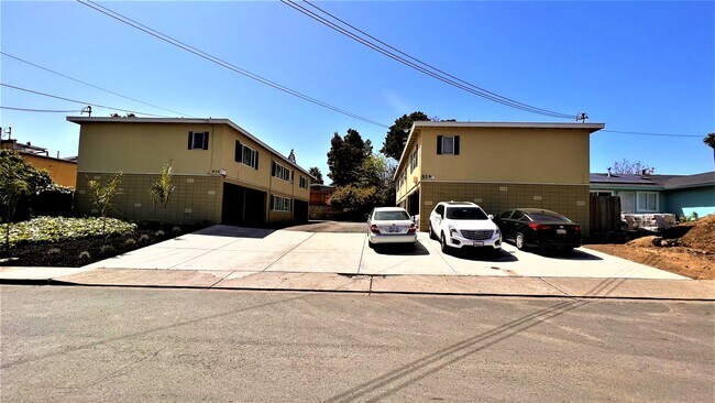
Property Record
929 Sheridan St, Vallejo, CA 94590


NEARBY LISTINGS FOR SALE OR LEASE
Property Detail
929 Sheridan St
Vallejo, CA
City Vallejo
0061-213-020
BK-BG 00-00
Multifamilydwelling
Solano
X
California
06095C0628G
15
2024
0.23 AC
2025
South Vallejo
250701
North Bay/Santa Rosa
5,184 SF
DEMOGRAPHICS near 929 Sheridan St
1 mile
3 mile
5 mile
2024 Total Population
15,308
90,629
161,820
2029 Population
15,140
89,643
159,924
Pop Growth 2024-2029
(1.10%)
(1.09%)
(1.17%)
Average Age
37
41
41
2024 Total Households
5,054
33,519
57,191
HH Growth 2024-2029
(1.05%)
(1.07%)
(1.16%)
Median Household Inc
$69,824
$74,771
$83,927
Avg Household Size
2.80
2.60
2.70
2024 Avg HH Vehicles
2.00
2.00
2.00
Median Home Value
$417,399
$562,338
$604,081
Median Year Built
1966
1966
1974
Nearby Places
Map Layers
Map Styles
 Street
 Aerial
Transit
 Traffic
 Biking
Places
Listings with unknown addresses are not visible on the map
- Restaurants
- Banks
- Shops
- Fitness
- Groceries
PUBLIC TRANSPORTATION
AIRPORT
Metro Oakland International
Drive
Walk
Distance
Metro Oakland International
43 min
33.5 mi
Freight Ports
Port of Richmond
Drive
Walk
Distance
Port of Richmond
28 min
19.2 mi
SALE & LEASE HISTORY
LISTING DATE
SALE/LEASE

Apr 07, 2022
For Sale
Nearby Properties
Address
Land Use
TOTAL SIZE
Lot Size
Zoning
Address
Land Use
TOTAL SIZE
Lot Size
Zoning
432,550 SF
29.70 AC
Address
Land Use
TOTAL SIZE
Lot Size
Zoning
67.14 AC
HI
Address
Land Use
TOTAL SIZE
Lot Size
Zoning
76.36 AC
HI
Address
Land Use
TOTAL SIZE
Lot Size
Zoning
1,053 SF
7.78 AC
HI
Address
Land Use
TOTAL SIZE
Lot Size
Zoning
49.85 AC
HI
Address
Land Use
TOTAL SIZE
Lot Size
Zoning
349.61 AC
Address
Land Use
TOTAL SIZE
Lot Size
Zoning
197,656 SF
18.63 AC
Address
Land Use
TOTAL SIZE
Lot Size
Zoning
123,566 SF
7.17 AC
Address
Land Use
TOTAL SIZE
Lot Size
Zoning
176,119 SF
6.80 AC
CHANGE-MUL
Address
Land Use
TOTAL SIZE
Lot Size
Zoning
Address
Land Use
TOTAL SIZE
Lot Size
Zoning
17.66 AC
Address
Land Use
TOTAL SIZE
Lot Size
Zoning
43.81 AC
Address
Land Use
TOTAL SIZE
Lot Size
Zoning
7.86 AC
Address
Land Use
TOTAL SIZE
Lot Size
Zoning
128,544 SF
5.92 AC
Address
Land Use
TOTAL SIZE
Lot Size
Zoning
175,831 SF
8.63 AC
Address
Land Use
TOTAL SIZE
Lot Size
Zoning
151,720 SF
8 AC
HDR
Address
Land Use
TOTAL SIZE
Lot Size
Zoning
240,905 SF
19.12 AC
Address
Land Use
TOTAL SIZE
Lot Size
Zoning
108,316 SF
5.31 AC
MULTI RES
Address
Land Use
TOTAL SIZE
Lot Size
Zoning
73,819 SF
5.64 AC
Address
Land Use
TOTAL SIZE
Lot Size
Zoning
178,265 SF
10.87 AC
Address
Land Use
TOTAL SIZE
Lot Size
Zoning
119,746 SF
0.64 AC
Address
Land Use
TOTAL SIZE
Lot Size
Zoning
83,768 SF
4.08 AC
Address
Land Use
TOTAL SIZE
Lot Size
Zoning
140,712 SF
9.54 AC
Address
Land Use
TOTAL SIZE
Lot Size
Zoning
86,116 SF
4.64 AC
Address
Land Use
TOTAL SIZE
Lot Size
Zoning
82,058 SF
6.45 AC
Address
Land Use
TOTAL SIZE
Lot Size
Zoning
78,742 SF
0.67 AC
Address
Land Use
TOTAL SIZE
Lot Size
Zoning
69,011 SF
3.67 AC
PUBLIC-PF
Address
Land Use
TOTAL SIZE
Lot Size
Zoning
57,267 SF
3.42 AC
Address
Land Use
TOTAL SIZE
Lot Size
Zoning
65,856 SF
3.49 AC
Address
Land Use
TOTAL SIZE
Lot Size
Zoning
307,400 SF
5.52 AC
The World's #1 Commercial Real Estate Marketplace
Connect with us
© 2026 CoStar Group
The information above has been obtained from sources believed reliable. While we do not doubt its accuracy we have not verified it and make no guarantee, warranty or representation about it. It is your responsibility to independently confirm its accuracy and completeness. Any projections, opinions, assumptions, or estimates used are for example only and do not represent the current or future performance of the property. The value of this transaction to you depends on tax and other factors which should be evaluated by your tax, financial, and legal advisors. You and your advisors should conduct a careful, independent investigation of the property to determine to your satisfaction the suitability of the property for your needs.