Property Record
1099 E Evergreen St, Strafford, MO 65757
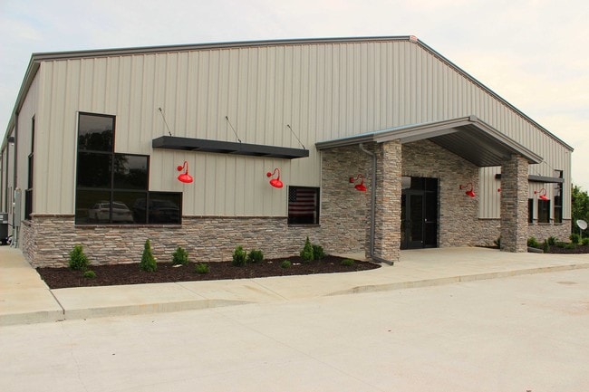


Property Detail
1099 E Evergreen St
Springfield, MO
16.22A M/L BEG NW COR SE1/4 SW1/4 36/30/20 E 668.78 FT S 1059.71 FT W 668.87 FT N 1052.64 FT TO BEG 36/30/20 BILLBOARD ON LEASED LAND ON PARCEL 88-10-36-300-026
10-36-300-031
GREENE
Warehouse
Missouri
2025
16.22 AC
2025
Outlying Greene County
004601
Springfield
NEARBY LISTINGS FOR SALE OR LEASE
-
-
View all Strafford listings for sale on LoopNet.com
DEMOGRAPHICS near 1099 E Evergreen St
1 mile
3 mile
5 mile
2025 Total Population
294
4,683
7,610
2030 Population
309
4,897
7,945
Pop Growth 2025-2030
+ 5.10%
+ 4.57%
+ 4.40%
Average Age
37
40
41
2025 Total Households
105
1,772
2,934
HH Growth 2025-2030
+ 4.76%
+ 4.68%
+ 4.53%
Median Household Inc
$75,568
$73,403
$77,259
Avg Household Size
2.70
2.60
2.50
2025 Avg HH Vehicles
2.00
2.00
2.00
Median Home Value
$192,307
$216,272
$250,444
Median Year Built
1993
1989
1988
Nearby Places
Map Layers
Map Styles
 Street
 Aerial
Layers
 Traffic
 Biking
Places
Listings with unknown addresses are not visible on the map
- Restaurants
- Banks
- Shops
- Fitness
- Groceries
PUBLIC TRANSPORTATION
AIRPORT
Springfield-Branson Ntl
Drive
Walk
Distance
Springfield-Branson Ntl
32 min
21.4 mi
Freight Ports
Tulsa Port of Inola
Drive
Walk
Distance
Tulsa Port of Inola
205 min
183.7 mi
SALE & LEASE HISTORY
LISTING DATE
SALE/LEASE

Sep 23, 2016
For Sale
Oct 22, 2019
For Sale
Nearby Properties
Address
Land Use
TOTAL SIZE
Lot Size
Zoning
Address
Land Use
TOTAL SIZE
Lot Size
Zoning
9.17 AC
INC.
Address
Land Use
TOTAL SIZE
Lot Size
Zoning
8.66 AC
INC
Address
Land Use
TOTAL SIZE
Lot Size
Zoning
10.11 AC
INC
Address
Land Use
TOTAL SIZE
Lot Size
Zoning
85.20 AC
Address
Land Use
TOTAL SIZE
Lot Size
Zoning
18,820 SF
24.63 AC
Address
Land Use
TOTAL SIZE
Lot Size
Zoning
1,500 SF
27.47 AC
Address
Land Use
TOTAL SIZE
Lot Size
Zoning
10.07 AC
INC.
Address
Land Use
TOTAL SIZE
Lot Size
Zoning
17.48 AC
INC
Address
Land Use
TOTAL SIZE
Lot Size
Zoning
Address
Land Use
TOTAL SIZE
Lot Size
Zoning
17.36 AC
INC.
Address
Land Use
TOTAL SIZE
Lot Size
Zoning
10 AC
INC.
Address
Land Use
TOTAL SIZE
Lot Size
Zoning
12.03 AC
INC
Address
Land Use
TOTAL SIZE
Lot Size
Zoning
2.97 AC
INC
Address
Land Use
TOTAL SIZE
Lot Size
Zoning
22,000 SF
13.72 AC
Address
Land Use
TOTAL SIZE
Lot Size
Zoning
23,806 SF
42.74 AC
INC
Address
Land Use
TOTAL SIZE
Lot Size
Zoning
2.79 AC
INC
Address
Land Use
TOTAL SIZE
Lot Size
Zoning
6.93 AC
INC
Address
Land Use
TOTAL SIZE
Lot Size
Zoning
31,101 SF
12 AC
INC
Address
Land Use
TOTAL SIZE
Lot Size
Zoning
1,364 SF
14.79 AC
INC
Address
Land Use
TOTAL SIZE
Lot Size
Zoning
8.98 AC
INC
Address
Land Use
TOTAL SIZE
Lot Size
Zoning
Address
Land Use
TOTAL SIZE
Lot Size
Zoning
14,080 SF
10.71 AC
Address
Land Use
TOTAL SIZE
Lot Size
Zoning
2.06 AC
INC.
Address
Land Use
TOTAL SIZE
Lot Size
Zoning
8,146 SF
2.32 AC
INC
Address
Land Use
TOTAL SIZE
Lot Size
Zoning
4,253 SF
26.40 AC
INC
Address
Land Use
TOTAL SIZE
Lot Size
Zoning
14,556 SF
4.71 AC
Address
Land Use
TOTAL SIZE
Lot Size
Zoning
5,519 SF
2.85 AC
INC
Address
Land Use
TOTAL SIZE
Lot Size
Zoning
5,643 SF
3.49 AC
INC
Address
Land Use
TOTAL SIZE
Lot Size
Zoning
12.35 AC
INC
The World's #1 Commercial Real Estate Marketplace
Connect with us
© 2026 CoStar Group
The information above has been obtained from sources believed reliable. While we do not doubt its accuracy we have not verified it and make no guarantee, warranty or representation about it. It is your responsibility to independently confirm its accuracy and completeness. Any projections, opinions, assumptions, or estimates used are for example only and do not represent the current or future performance of the property. The value of this transaction to you depends on tax and other factors which should be evaluated by your tax, financial, and legal advisors. You and your advisors should conduct a careful, independent investigation of the property to determine to your satisfaction the suitability of the property for your needs.