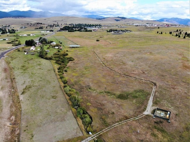
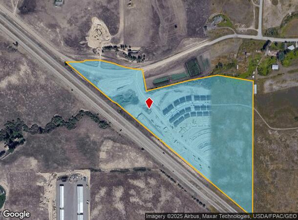
Property Record
9299 Liam Loop, Missoula, MT 59808
NEARBY LISTINGS FOR SALE OR LEASE
Property Detail
9299 Liam Loop
Missoula, MT
Cert/Surv 3006
04-2325-20-1-01-05-0000
S20, T14 N, R20 W, C.O.S. 3006, ACRES 30.76, PARCEL B NE4
Commercialnec
Missoula
X
Montana
30063C1160E
b
2024
30.76 AC
2025
Missoula
000206
Other Market Areas
5,991 SF
DEMOGRAPHICS near 9299 Liam Loop
1 Mile
3 Mile
5 Mile
2024 Total Population
436
3,014
6,058
2029 Population
463
3,202
6,457
Pop Growth 2024-2029
+ 6.19%
+ 6.24%
+ 6.59%
Average Age
39
39
40
2024 Total Households
155
1,085
2,241
HH Growth 2024-2029
+ 6.45%
+ 6.27%
+ 6.65%
Median Household Inc
$125,694
$113,012
$107,824
Avg Household Size
2.80
2.70
2.60
2024 Avg HH Vehicles
3.00
3.00
2.00
Median Home Value
$434,848
$429,301
$448,750
Median Year Built
2000
1998
1997
Nearby Places
Map Layers
Map Styles
 Street
 Aerial
- Restaurants
- Banks
- Shops
- Fitness
- Groceries
PUBLIC TRANSPORTATION
AIRPORT
Missoula Montana
DRIVE
WALK
Distance
Missoula Montana
20 min
15.9 mi
Freight Ports
Port of Everett
DRIVE
WALK
Distance
Port of Everett
536 min
488.4 mi
SALE & LEASE HISTORY
LISTING DATE
SALE/LEASE

Nov 01, 2017
For Sale
Nearby Properties
Address
Land Use
TOTAL SIZE
Lot Size
Zoning
Address
Land Use
TOTAL SIZE
Lot Size
Zoning
72,000 SF
7.67 AC
Address
Land Use
TOTAL SIZE
Lot Size
Zoning
21,622 SF
14.69 AC
Address
Land Use
TOTAL SIZE
Lot Size
Zoning
135,960 SF
9.31 AC
Address
Land Use
TOTAL SIZE
Lot Size
Zoning
30,217 SF
18.51 AC
Address
Land Use
TOTAL SIZE
Lot Size
Zoning
71,348 SF
9.68 AC
Address
Land Use
TOTAL SIZE
Lot Size
Zoning
29,700 SF
2.18 AC
Address
Land Use
TOTAL SIZE
Lot Size
Zoning
38,060 SF
10.20 AC
Address
Land Use
TOTAL SIZE
Lot Size
Zoning
464,916 SF
69 AC
Address
Land Use
TOTAL SIZE
Lot Size
Zoning
43,490 SF
9.80 AC
Address
Land Use
TOTAL SIZE
Lot Size
Zoning
25,629 SF
5.89 AC
9
Address
Land Use
TOTAL SIZE
Lot Size
Zoning
42,461 SF
10.43 AC
Address
Land Use
TOTAL SIZE
Lot Size
Zoning
39,506 SF
9.68 AC
Address
Land Use
TOTAL SIZE
Lot Size
Zoning
49,908 SF
9.14 AC
Address
Land Use
TOTAL SIZE
Lot Size
Zoning
26,567 SF
20.38 AC
Address
Land Use
TOTAL SIZE
Lot Size
Zoning
30,000 SF
1.50 AC
Address
Land Use
TOTAL SIZE
Lot Size
Zoning
4,608 SF
44.65 AC
Address
Land Use
TOTAL SIZE
Lot Size
Zoning
13,592 SF
4.48 AC
Address
Land Use
TOTAL SIZE
Lot Size
Zoning
52,670 SF
6.58 AC
Address
Land Use
TOTAL SIZE
Lot Size
Zoning
16,560 SF
7.69 AC
Address
Land Use
TOTAL SIZE
Lot Size
Zoning
2,256 SF
24.35 AC
Address
Land Use
TOTAL SIZE
Lot Size
Zoning
16,583 SF
8.41 AC
Address
Land Use
TOTAL SIZE
Lot Size
Zoning
18,468 SF
17.95 AC
Address
Land Use
TOTAL SIZE
Lot Size
Zoning
16,620 SF
21.16 AC
Address
Land Use
TOTAL SIZE
Lot Size
Zoning
46,376 SF
11.25 AC
Address
Land Use
TOTAL SIZE
Lot Size
Zoning
26,552 SF
3.59 AC
Address
Land Use
TOTAL SIZE
Lot Size
Zoning
38,796 SF
12.84 AC
Address
Land Use
TOTAL SIZE
Lot Size
Zoning
3,488 SF
326.19 AC
Address
Land Use
TOTAL SIZE
Lot Size
Zoning
23,280 SF
2.58 AC
Address
Land Use
TOTAL SIZE
Lot Size
Zoning
24,176 SF
8.42 AC
The World's #1 Commercial Real Estate Marketplace
Connect with us
© 2025 CoStar Group
The information above has been obtained from sources believed reliable. While we do not doubt its accuracy we have not verified it and make no guarantee, warranty or representation about it. It is your responsibility to independently confirm its accuracy and completeness. Any projections, opinions, assumptions, or estimates used are for example only and do not represent the current or future performance of the property. The value of this transaction to you depends on tax and other factors which should be evaluated by your tax, financial, and legal advisors. You and your advisors should conduct a careful, independent investigation of the property to determine to your satisfaction the suitability of the property for your needs.