Property Record
93 Gilmore Dr, Sutton, MA 01590
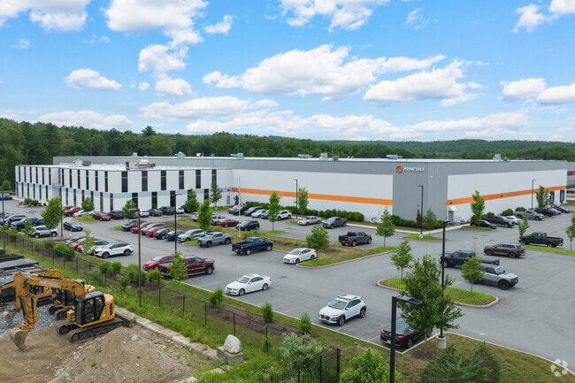

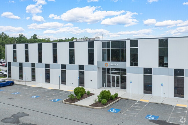
Property Detail
93 Gilmore Dr
Commercialbuilding
WORCESTER
OLI
Massachusetts
C and X Area of minimal flood hazard, usually depicted on FIRMs as above the 500-year flood level.
16.35 AC
2025
Outlying Worcester
2025
Boston
751101
Worcester, MA
185,400 SF
SUTT-000045-000000-000068
NEARBY LISTINGS FOR SALE OR LEASE
DEMOGRAPHICS near 93 Gilmore Dr
1 mile
3 mile
5 mile
2025 Total Population
831
14,377
45,614
2030 Population
862
14,764
46,795
Pop Growth 2025-2030
+ 3.73%
+ 2.69%
+ 2.59%
Average Age
43
42
42
2025 Total Households
298
5,469
17,682
HH Growth 2025-2030
+ 3.69%
+ 2.76%
+ 2.68%
Median Household Inc
$190,217
$120,304
$123,774
Avg Household Size
2.70
2.60
2.50
2025 Avg HH Vehicles
2.00
2.00
2.00
Median Home Value
$638,709
$493,284
$481,140
Median Year Built
1982
1971
1977
Nearby Places
Map Layers
Map Styles
 Street
 Aerial
Layers
 Traffic
 Biking
Places
Listings with unknown addresses are not visible on the map
- Restaurants
- Banks
- Shops
- Fitness
- Groceries
PUBLIC TRANSPORTATION
AIRPORT
Worcester Regional
Drive
Walk
Distance
Worcester Regional
30 min
19.3 mi
Freight Ports
Port of Davisville, RI
Drive
Walk
Distance
Port of Davisville, RI
62 min
47.1 mi
Nearby Properties
Address
Land Use
TOTAL SIZE
Lot Size
Zoning
Address
Land Use
TOTAL SIZE
Lot Size
Zoning
607,486 SF
69.67 AC
AG
Address
Land Use
TOTAL SIZE
Lot Size
Zoning
161,541 SF
30.04 AC
Address
Land Use
TOTAL SIZE
Lot Size
Zoning
6,743 SF
7.12 AC
IND
Address
Land Use
TOTAL SIZE
Lot Size
Zoning
216,167 SF
26.06 AC
C
Address
Land Use
TOTAL SIZE
Lot Size
Zoning
173,667 SF
2.44 AC
Address
Land Use
TOTAL SIZE
Lot Size
Zoning
246,552 SF
24.55 AC
Address
Land Use
TOTAL SIZE
Lot Size
Zoning
607,486 SF
31.09 AC
OLI
Address
Land Use
TOTAL SIZE
Lot Size
Zoning
178,775 SF
36.78 AC
Address
Land Use
TOTAL SIZE
Lot Size
Zoning
312,077 SF
13.66 AC
C
Address
Land Use
TOTAL SIZE
Lot Size
Zoning
116,864 SF
16.87 AC
OLI
Address
Land Use
TOTAL SIZE
Lot Size
Zoning
37,781 SF
29.16 AC
Address
Land Use
TOTAL SIZE
Lot Size
Zoning
55,671 SF
3.53 AC
Address
Land Use
TOTAL SIZE
Lot Size
Zoning
67,716 SF
42.39 AC
Address
Land Use
TOTAL SIZE
Lot Size
Zoning
90,000 SF
9.40 AC
OLI
Address
Land Use
TOTAL SIZE
Lot Size
Zoning
134,072 SF
8.27 AC
VB
Address
Land Use
TOTAL SIZE
Lot Size
Zoning
19,913 SF
0.78 AC
Address
Land Use
TOTAL SIZE
Lot Size
Zoning
607,486 SF
3.84 AC
IND
Address
Land Use
TOTAL SIZE
Lot Size
Zoning
100,882 SF
25.60 AC
Address
Land Use
TOTAL SIZE
Lot Size
Zoning
52,848 SF
7.02 AC
OLI
Address
Land Use
TOTAL SIZE
Lot Size
Zoning
27,918 SF
53.83 AC
OLI
Address
Land Use
TOTAL SIZE
Lot Size
Zoning
6.17 AC
Address
Land Use
TOTAL SIZE
Lot Size
Zoning
2.72 AC
Address
Land Use
TOTAL SIZE
Lot Size
Zoning
29,851 SF
7.27 AC
OLI
Address
Land Use
TOTAL SIZE
Lot Size
Zoning
57,554 SF
2.19 AC
Address
Land Use
TOTAL SIZE
Lot Size
Zoning
28,875 SF
0.61 AC
Address
Land Use
TOTAL SIZE
Lot Size
Zoning
44,668 SF
3.84 AC
Address
Land Use
TOTAL SIZE
Lot Size
Zoning
1,950 SF
506 AC
R1
Address
Land Use
TOTAL SIZE
Lot Size
Zoning
87.37 AC
IND
Address
Land Use
TOTAL SIZE
Lot Size
Zoning
30,742 SF
5.42 AC
CB
The World's #1 Commercial Real Estate Marketplace
Connect with us
© 2026 CoStar Group
The information above has been obtained from sources believed reliable. While we do not doubt its accuracy we have not verified it and make no guarantee, warranty or representation about it. It is your responsibility to independently confirm its accuracy and completeness. Any projections, opinions, assumptions, or estimates used are for example only and do not represent the current or future performance of the property. The value of this transaction to you depends on tax and other factors which should be evaluated by your tax, financial, and legal advisors. You and your advisors should conduct a careful, independent investigation of the property to determine to your satisfaction the suitability of the property for your needs.