Property Record
93 Mine Rd, Bristol, CT 06010

NEARBY LISTINGS FOR SALE OR LEASE
-
-
View all Bristol listings for sale on LoopNet.com
Property Detail
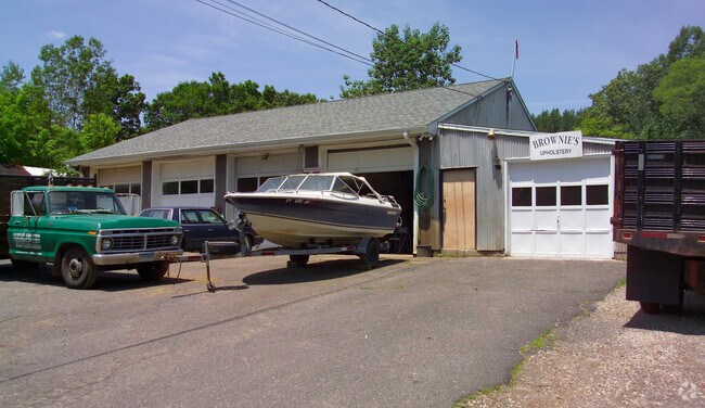
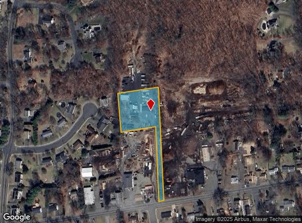
93 Mine Rd
BRIS-000051-000000-000010-000002
Hartford
Commercialnec
Connecticut
X
10-2
09003C0456F
1.24 AC
2025
Bristol
2025
Hartford
405100
Hartford-West Hartford-East Hartford, CT
2,660 SF
DEMOGRAPHICS near 93 Mine Rd
1 Mile
3 Mile
5 Mile
2024 Total Population
5,223
43,774
106,232
2029 Population
5,193
43,619
106,083
Pop Growth 2024-2029
(0.57%)
(0.35%)
(0.14%)
Average Age
43
43
42
2024 Total Households
2,036
17,701
44,153
HH Growth 2024-2029
(0.64%)
(0.38%)
(0.16%)
Median Household Inc
$97,846
$89,855
$82,900
Avg Household Size
2.50
2.40
2.30
2024 Avg HH Vehicles
2.00
2.00
2.00
Median Home Value
$261,691
$267,159
$267,625
Median Year Built
1969
1969
1970
Nearby Places
Map Layers
Map Styles
 Street
 Aerial
- Restaurants
- Banks
- Shops
- Fitness
- Groceries
PUBLIC TRANSPORTATION
AIRPORT
Bradley International
DRIVE
WALK
Distance
Bradley International
45 min
31.7 mi
Freight Ports
Albany, NY Port
DRIVE
WALK
Distance
Albany, NY Port
1 min
75.8 mi
Nearby Properties
Address
Land Use
TOTAL SIZE
Lot Size
Zoning
Address
Land Use
TOTAL SIZE
Lot Size
Zoning
268,369 SF
13.32 AC
B1
Address
Land Use
TOTAL SIZE
Lot Size
Zoning
137,242 SF
25.80 AC
R40
Address
Land Use
TOTAL SIZE
Lot Size
Zoning
12 AC
R20
Address
Land Use
TOTAL SIZE
Lot Size
Zoning
56,184 SF
19.42 AC
BG
Address
Land Use
TOTAL SIZE
Lot Size
Zoning
24.61 AC
CR
Address
Land Use
TOTAL SIZE
Lot Size
Zoning
199,744 SF
44.70 AC
R-15
Address
Land Use
TOTAL SIZE
Lot Size
Zoning
169,727 SF
23.90 AC
R-25
Address
Land Use
TOTAL SIZE
Lot Size
Zoning
54,904 SF
7.01 AC
A
Address
Land Use
TOTAL SIZE
Lot Size
Zoning
133,673 SF
30.40 AC
R-40
Address
Land Use
TOTAL SIZE
Lot Size
Zoning
4,000 SF
13.78 AC
BG
Address
Land Use
TOTAL SIZE
Lot Size
Zoning
120,801 SF
8.35 AC
R-40
Address
Land Use
TOTAL SIZE
Lot Size
Zoning
46,768 SF
40.04 AC
R40
Address
Land Use
TOTAL SIZE
Lot Size
Zoning
143,315 SF
4.50 AC
A
Address
Land Use
TOTAL SIZE
Lot Size
Zoning
42,516 SF
10.40 AC
BG
Address
Land Use
TOTAL SIZE
Lot Size
Zoning
41,011 SF
8.50 AC
BG
Address
Land Use
TOTAL SIZE
Lot Size
Zoning
118,573 SF
9.75 AC
BG
Address
Land Use
TOTAL SIZE
Lot Size
Zoning
147,132 SF
12.50 AC
BG
Address
Land Use
TOTAL SIZE
Lot Size
Zoning
52,128 SF
7.20 AC
A
Address
Land Use
TOTAL SIZE
Lot Size
Zoning
122,737 SF
17.20 AC
BG
Address
Land Use
TOTAL SIZE
Lot Size
Zoning
1,250 SF
14.90 AC
I
Address
Land Use
TOTAL SIZE
Lot Size
Zoning
4,209 SF
14.60 AC
A
Address
Land Use
TOTAL SIZE
Lot Size
Zoning
60,935 SF
0.92 AC
BD-1
Address
Land Use
TOTAL SIZE
Lot Size
Zoning
230.65 AC
CR
Address
Land Use
TOTAL SIZE
Lot Size
Zoning
71,531 SF
23.80 AC
R-15
Address
Land Use
TOTAL SIZE
Lot Size
Zoning
56,245 SF
39.20 AC
R-15
Address
Land Use
TOTAL SIZE
Lot Size
Zoning
85,302 SF
27.94 AC
R44
Address
Land Use
TOTAL SIZE
Lot Size
Zoning
55,022 SF
11.30 AC
R-15
Address
Land Use
TOTAL SIZE
Lot Size
Zoning
22,022 SF
8 AC
BG
Address
Land Use
TOTAL SIZE
Lot Size
Zoning
7,482 SF
5.80 AC
R-15
Address
Land Use
TOTAL SIZE
Lot Size
Zoning
41,483 SF
16.50 AC
R-15
The World's #1 Commercial Real Estate Marketplace
Connect with us
© 2026 CoStar Group
The information above has been obtained from sources believed reliable. While we do not doubt its accuracy we have not verified it and make no guarantee, warranty or representation about it. It is your responsibility to independently confirm its accuracy and completeness. Any projections, opinions, assumptions, or estimates used are for example only and do not represent the current or future performance of the property. The value of this transaction to you depends on tax and other factors which should be evaluated by your tax, financial, and legal advisors. You and your advisors should conduct a careful, independent investigation of the property to determine to your satisfaction the suitability of the property for your needs.