Property Record
930 10Th Ave, Columbus, GA 31901
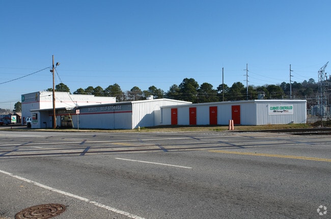

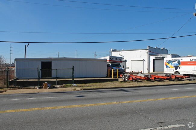
Property Detail
930 10Th Ave
Columbus, GA-AL
B - LT 2 PT LTS 1 & 6 THEO MCGEE PARK SEC 2
019-008-003
Muscogee
Commercialnec
Georgia
AH Areas with a 1% annual chance of shallow flooding, usually in the form of a pond, withan average depth ranging from 1 to 3 feet. These areas have a 26% chance of flooding over the life of a 30-year mortgage.
2-6
2025
1.26 AC
2025
Greater Columbus
002400
Columbus GA
9,496 SF
NEARBY LISTINGS FOR SALE OR LEASE
DEMOGRAPHICS near 930 10Th Ave
1 mile
3 mile
5 mile
2025 Total Population
6,962
64,711
140,864
2030 Population
6,917
64,413
138,571
Pop Growth 2025-2030
(0.65%)
(0.46%)
(1.63%)
Average Age
38
38
39
2025 Total Households
3,384
28,326
58,924
HH Growth 2025-2030
(0.24%)
(0.23%)
(1.39%)
Median Household Inc
$33,928
$34,710
$41,436
Avg Household Size
1.90
2.20
2.30
2025 Avg HH Vehicles
1.00
1.00
1.00
Median Home Value
$278,868
$149,577
$157,783
Median Year Built
1961
1964
1969
Nearby Places
Map Layers
Map Styles
 Street
 Aerial
Layers
 Traffic
 Biking
Places
Listings with unknown addresses are not visible on the map
- Restaurants
- Banks
- Shops
- Fitness
- Groceries
PUBLIC TRANSPORTATION
AIRPORT
Columbus
Drive
Walk
Distance
Columbus
11 min
6.4 mi
Freight Ports
Port of Panama City
Drive
Walk
Distance
Port of Panama City
231 min
183.9 mi
Nearby Properties
Address
Land Use
TOTAL SIZE
Lot Size
Zoning
Address
Land Use
TOTAL SIZE
Lot Size
Zoning
68,000 SF
11.21 AC
Address
Land Use
TOTAL SIZE
Lot Size
Zoning
32,750 SF
4.01 AC
Address
Land Use
TOTAL SIZE
Lot Size
Zoning
2.48 AC
Address
Land Use
TOTAL SIZE
Lot Size
Zoning
43,888 SF
2 AC
Address
Land Use
TOTAL SIZE
Lot Size
Zoning
55,900 SF
27.05 AC
Address
Land Use
TOTAL SIZE
Lot Size
Zoning
216,360 SF
17.51 AC
Address
Land Use
TOTAL SIZE
Lot Size
Zoning
65,875 SF
2.37 AC
Address
Land Use
TOTAL SIZE
Lot Size
Zoning
63,220 SF
3.49 AC
Address
Land Use
TOTAL SIZE
Lot Size
Zoning
5,592 SF
13.41 AC
Address
Land Use
TOTAL SIZE
Lot Size
Zoning
56,095 SF
25.91 AC
Address
Land Use
TOTAL SIZE
Lot Size
Zoning
27,621 SF
6.33 AC
Address
Land Use
TOTAL SIZE
Lot Size
Zoning
2.31 AC
Address
Land Use
TOTAL SIZE
Lot Size
Zoning
32,238 SF
7.21 AC
Address
Land Use
TOTAL SIZE
Lot Size
Zoning
10,705 SF
0.64 AC
Address
Land Use
TOTAL SIZE
Lot Size
Zoning
31,847 SF
1.21 AC
Address
Land Use
TOTAL SIZE
Lot Size
Zoning
4,334 SF
13.29 AC
Address
Land Use
TOTAL SIZE
Lot Size
Zoning
247,570 SF
28.07 AC
Address
Land Use
TOTAL SIZE
Lot Size
Zoning
1.21 AC
Address
Land Use
TOTAL SIZE
Lot Size
Zoning
34,866 SF
2.34 AC
Address
Land Use
TOTAL SIZE
Lot Size
Zoning
18,050 SF
1.17 AC
Address
Land Use
TOTAL SIZE
Lot Size
Zoning
142,703 SF
28.48 AC
Address
Land Use
TOTAL SIZE
Lot Size
Zoning
29,640 SF
1.11 AC
Address
Land Use
TOTAL SIZE
Lot Size
Zoning
Address
Land Use
TOTAL SIZE
Lot Size
Zoning
45,932 SF
29 AC
Address
Land Use
TOTAL SIZE
Lot Size
Zoning
83,295 SF
17.87 AC
Address
Land Use
TOTAL SIZE
Lot Size
Zoning
78,948 SF
6 AC
Address
Land Use
TOTAL SIZE
Lot Size
Zoning
72,200 SF
5.52 AC
Address
Land Use
TOTAL SIZE
Lot Size
Zoning
2,870 SF
8.75 AC
Address
Land Use
TOTAL SIZE
Lot Size
Zoning
56,775 SF
4.26 AC
Address
Land Use
TOTAL SIZE
Lot Size
Zoning
41,084 SF
5.58 AC
The World's #1 Commercial Real Estate Marketplace
Connect with us
© 2026 CoStar Group
The information above has been obtained from sources believed reliable. While we do not doubt its accuracy we have not verified it and make no guarantee, warranty or representation about it. It is your responsibility to independently confirm its accuracy and completeness. Any projections, opinions, assumptions, or estimates used are for example only and do not represent the current or future performance of the property. The value of this transaction to you depends on tax and other factors which should be evaluated by your tax, financial, and legal advisors. You and your advisors should conduct a careful, independent investigation of the property to determine to your satisfaction the suitability of the property for your needs.