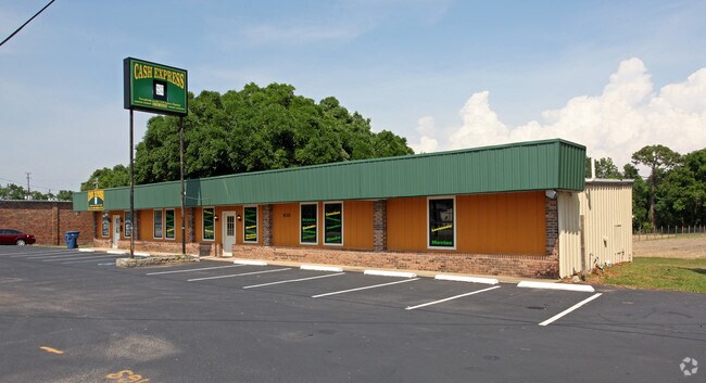
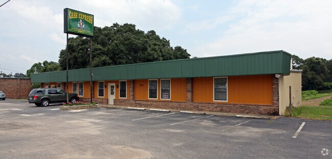
Property Record
930 Saraland Blvd S, Saraland, AL 36571

Property Detail
930 Saraland Blvd S
22-02-10-2-000-040
BEG INT E/L HWY 43 & NW 1/4 SEC 10 T3S R1W RUN SE 405 FT(S) TO W/L FRISCO RR N ALG W/L 135 FT(S) TO PT TH W 410 FT(S) TH S
Storesoffices
Mobile
C and X Area of minimal flood hazard, usually depicted on FIRMs as above the 500-year flood level.
Alabama
2025
1.23 AC
2025
Northeast Mobile
005400
Mobile
2,525 SF
Mobile, AL
NEARBY LISTINGS FOR SALE OR LEASE
DEMOGRAPHICS near 930 Saraland Blvd S
1 mile
3 mile
5 mile
2025 Total Population
2,695
17,164
42,856
2030 Population
2,690
16,996
43,183
Pop Growth 2025-2030
(0.19%)
(0.98%)
+ 0.76%
Average Age
39
39
40
2025 Total Households
1,181
6,881
16,676
HH Growth 2025-2030
(0.17%)
(1.00%)
+ 0.81%
Median Household Inc
$37,954
$48,839
$45,380
Avg Household Size
2.20
2.50
2.50
2025 Avg HH Vehicles
2.00
2.00
2.00
Median Home Value
$219,129
$180,325
$148,542
Median Year Built
1976
1970
1972
Nearby Places
Map Layers
Map Styles
 Street
 Aerial
Layers
 Traffic
 Biking
Places
Listings with unknown addresses are not visible on the map
- Restaurants
- Banks
- Shops
- Fitness
- Groceries
PUBLIC TRANSPORTATION
AIRPORT
Mobile International
Drive
Walk
Distance
Mobile International
23 min
13.8 mi
Mobile Regional
Drive
Walk
Distance
Mobile Regional
33 min
19.1 mi
Freight Ports
Port of Mobile
Drive
Walk
Distance
Port of Mobile
13 min
8.6 mi
Nearby Properties
Address
Land Use
TOTAL SIZE
Lot Size
Zoning
Address
Land Use
TOTAL SIZE
Lot Size
Zoning
66,138 SF
35.24 AC
Address
Land Use
TOTAL SIZE
Lot Size
Zoning
9,100 SF
34.07 AC
Address
Land Use
TOTAL SIZE
Lot Size
Zoning
35,775 SF
22.48 AC
Address
Land Use
TOTAL SIZE
Lot Size
Zoning
35,828 SF
26.30 AC
Address
Land Use
TOTAL SIZE
Lot Size
Zoning
187,257 SF
33.10 AC
Address
Land Use
TOTAL SIZE
Lot Size
Zoning
5,000 SF
13.33 AC
Address
Land Use
TOTAL SIZE
Lot Size
Zoning
21,700 SF
6.98 AC
Address
Land Use
TOTAL SIZE
Lot Size
Zoning
197,471 SF
15.90 AC
Address
Land Use
TOTAL SIZE
Lot Size
Zoning
66,678 SF
2.29 AC
Address
Land Use
TOTAL SIZE
Lot Size
Zoning
57,084 SF
1.97 AC
Address
Land Use
TOTAL SIZE
Lot Size
Zoning
97,443 SF
98.83 AC
Address
Land Use
TOTAL SIZE
Lot Size
Zoning
116,512 SF
9.60 AC
Address
Land Use
TOTAL SIZE
Lot Size
Zoning
1,104 SF
6.01 AC
Address
Land Use
TOTAL SIZE
Lot Size
Zoning
45,980 SF
10.72 AC
Address
Land Use
TOTAL SIZE
Lot Size
Zoning
125,239 SF
11.20 AC
Address
Land Use
TOTAL SIZE
Lot Size
Zoning
35,952 SF
5.37 AC
Address
Land Use
TOTAL SIZE
Lot Size
Zoning
54,965 SF
1.97 AC
Address
Land Use
TOTAL SIZE
Lot Size
Zoning
3,188 SF
10.16 AC
Address
Land Use
TOTAL SIZE
Lot Size
Zoning
294,193 SF
7.06 AC
Address
Land Use
TOTAL SIZE
Lot Size
Zoning
86,174 SF
9.30 AC
Address
Land Use
TOTAL SIZE
Lot Size
Zoning
18,818 SF
6.21 AC
Address
Land Use
TOTAL SIZE
Lot Size
Zoning
114,942 SF
29 AC
Address
Land Use
TOTAL SIZE
Lot Size
Zoning
128,250 SF
13.83 AC
Address
Land Use
TOTAL SIZE
Lot Size
Zoning
40,245 SF
1.99 AC
Address
Land Use
TOTAL SIZE
Lot Size
Zoning
48,304 SF
3.28 AC
Address
Land Use
TOTAL SIZE
Lot Size
Zoning
76,682 SF
9.62 AC
Address
Land Use
TOTAL SIZE
Lot Size
Zoning
21,800 SF
6 AC
Address
Land Use
TOTAL SIZE
Lot Size
Zoning
58,789 SF
17 AC
Address
Land Use
TOTAL SIZE
Lot Size
Zoning
5,384 SF
18 AC
Address
Land Use
TOTAL SIZE
Lot Size
Zoning
122,776 SF
14.32 AC
The World's #1 Commercial Real Estate Marketplace
Connect with us
© 2026 CoStar Group
The information above has been obtained from sources believed reliable. While we do not doubt its accuracy we have not verified it and make no guarantee, warranty or representation about it. It is your responsibility to independently confirm its accuracy and completeness. Any projections, opinions, assumptions, or estimates used are for example only and do not represent the current or future performance of the property. The value of this transaction to you depends on tax and other factors which should be evaluated by your tax, financial, and legal advisors. You and your advisors should conduct a careful, independent investigation of the property to determine to your satisfaction the suitability of the property for your needs.