Property Record
9300 Nc Highway 65, Stokesdale, NC 27357


NEARBY LISTINGS FOR SALE OR LEASE
Property Detail
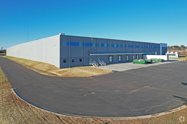
9300 Nc Highway 65
79210256345500
Richard W Friddle Estate
Manufacturinglight
43.64 AC PARCEL 1 RICHARD W FRIDDLE ESTATE SURVEY FRIDDLE ESTATE SURVEY
X
Rockingham
3710792100K
North Carolina
2025
43.64 AC
2025
Rockingham County
041001
Greensboro/Winston-Salem
264,990 SF
Greensboro-High Point, NC
DEMOGRAPHICS near 9300 Nc Highway 65
1 Mile
3 Mile
5 Mile
2024 Total Population
631
6,280
17,737
2029 Population
653
6,424
18,000
Pop Growth 2024-2029
+ 3.49%
+ 2.29%
+ 1.48%
Average Age
41
41
41
2024 Total Households
250
2,422
6,688
HH Growth 2024-2029
+ 3.60%
+ 2.31%
+ 1.50%
Median Household Inc
$61,071
$62,143
$82,683
Avg Household Size
2.50
2.50
2.60
2024 Avg HH Vehicles
2.00
2.00
2.00
Median Home Value
$158,124
$190,514
$253,480
Median Year Built
1992
1992
1994
Nearby Places
Map Layers
Map Styles
 Street
 Aerial
- Restaurants
- Banks
- Shops
- Fitness
- Groceries
PUBLIC TRANSPORTATION
AIRPORT
Piedmont Triad International
DRIVE
WALK
Distance
Piedmont Triad International
26 min
17.9 mi
Freight Ports
Virginia Port Authority - Richmond
DRIVE
WALK
Distance
Virginia Port Authority - Richmond
241 min
186.2 mi
Nearby Properties
Address
Land Use
TOTAL SIZE
Lot Size
Zoning
Address
Land Use
TOTAL SIZE
Lot Size
Zoning
516,172 SF
58.24 AC
LI
Address
Land Use
TOTAL SIZE
Lot Size
Zoning
173,448 SF
26.10 AC
LIGHT INDU
Address
Land Use
TOTAL SIZE
Lot Size
Zoning
516,221 SF
106.85 AC
AG
Address
Land Use
TOTAL SIZE
Lot Size
Zoning
121,825 SF
36.43 AC
GO-M
Address
Land Use
TOTAL SIZE
Lot Size
Zoning
4,511 SF
463.69 AC
AG
Address
Land Use
TOTAL SIZE
Lot Size
Zoning
6,600 SF
48.42 AC
RES AG COU
Address
Land Use
TOTAL SIZE
Lot Size
Zoning
8,774 SF
2.07 AC
HB
Address
Land Use
TOTAL SIZE
Lot Size
Zoning
14,080 SF
40.69 AC
IN MORE TH
Address
Land Use
TOTAL SIZE
Lot Size
Zoning
10,000 SF
2.12 AC
RES PROTEC
Address
Land Use
TOTAL SIZE
Lot Size
Zoning
7,752 SF
6.29 AC
RES AG/RES
Address
Land Use
TOTAL SIZE
Lot Size
Zoning
12,000 SF
4.43 AC
LI
Address
Land Use
TOTAL SIZE
Lot Size
Zoning
4,389 SF
119.23 AC
AG
Address
Land Use
TOTAL SIZE
Lot Size
Zoning
23,850 SF
8.38 AC
LI
Address
Land Use
TOTAL SIZE
Lot Size
Zoning
7,620 SF
60.13 AC
HI
Address
Land Use
TOTAL SIZE
Lot Size
Zoning
828 SF
37.20 AC
AG
Address
Land Use
TOTAL SIZE
Lot Size
Zoning
35,000 SF
5.48 AC
LI
Address
Land Use
TOTAL SIZE
Lot Size
Zoning
1,568 SF
84.67 AC
AG
Address
Land Use
TOTAL SIZE
Lot Size
Zoning
5,001 SF
16.06 AC
AG
Address
Land Use
TOTAL SIZE
Lot Size
Zoning
5,484 SF
9.64 AC
AG
Address
Land Use
TOTAL SIZE
Lot Size
Zoning
5,000 SF
7.30 AC
AG
Address
Land Use
TOTAL SIZE
Lot Size
Zoning
6,118 SF
100.25 AC
AG
Address
Land Use
TOTAL SIZE
Lot Size
Zoning
1,380 SF
66.36 AC
AG
Address
Land Use
TOTAL SIZE
Lot Size
Zoning
22,650 SF
5.23 AC
HWY COMM C
Address
Land Use
TOTAL SIZE
Lot Size
Zoning
20,000 SF
3.67 AC
LI
Address
Land Use
TOTAL SIZE
Lot Size
Zoning
5,696 SF
19.97 AC
AG
Address
Land Use
TOTAL SIZE
Lot Size
Zoning
54.72 AC
IN MORE TH
Address
Land Use
TOTAL SIZE
Lot Size
Zoning
2,676 SF
162.40 AC
AG
Address
Land Use
TOTAL SIZE
Lot Size
Zoning
21,450 SF
9.85 AC
LIGHT INDU
Address
Land Use
TOTAL SIZE
Lot Size
Zoning
2,447 SF
49.45 AC
AG
The World's #1 Commercial Real Estate Marketplace
Connect with us
© 2026 CoStar Group
The information above has been obtained from sources believed reliable. While we do not doubt its accuracy we have not verified it and make no guarantee, warranty or representation about it. It is your responsibility to independently confirm its accuracy and completeness. Any projections, opinions, assumptions, or estimates used are for example only and do not represent the current or future performance of the property. The value of this transaction to you depends on tax and other factors which should be evaluated by your tax, financial, and legal advisors. You and your advisors should conduct a careful, independent investigation of the property to determine to your satisfaction the suitability of the property for your needs.