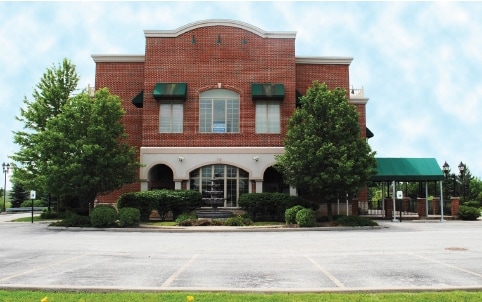
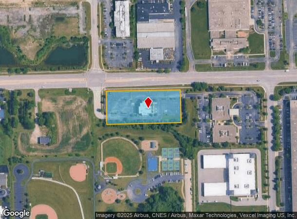
Property Record
9301 W 191St St, Mokena, IL 60448

NEARBY LISTINGS FOR SALE OR LEASE
Property Detail
9301 W 191St St
19-09-10-100-027
Corporate Cooridors
Commercialnec
THAT PRT OF THE E1/2 OF THE NE1/4 OF THE NW1/4 OF SEC. 10,T35N-R12E, LYG E OF A LN WHICH IS 500 FT E OF THE W 8 ACRES OF SD N
X
Will
17197C0212G
Illinois
2024
2.11 AC
2024
Joliet/Central Will
883513
Chicago
9,544 SF
Chicago-Naperville-Elgin, IL-IN-WI
DEMOGRAPHICS near 9301 W 191St St
1 Mile
3 Mile
5 Mile
2024 Total Population
5,798
59,545
154,524
2029 Population
5,755
58,705
151,622
Pop Growth 2024-2029
(0.74%)
(1.41%)
(1.88%)
Average Age
40
43
43
2024 Total Households
1,938
21,270
57,312
HH Growth 2024-2029
(0.72%)
(1.52%)
(2.19%)
Median Household Inc
$122,684
$116,327
$99,848
Avg Household Size
3.00
2.70
2.60
2024 Avg HH Vehicles
2.00
2.00
2.00
Median Home Value
$327,729
$316,875
$301,540
Median Year Built
1997
1993
1990
Nearby Places
Map Layers
Map Styles
 Street
 Aerial
- Restaurants
- Banks
- Shops
- Fitness
- Groceries
PUBLIC TRANSPORTATION
COMMUTER RAIL
Hickory Creek (Rock Island - Metra)
DRIVE
WALK
Distance
Hickory Creek (Rock Island - Metra)
2 min
10 min
0.6 mi
Tinley Park - 80Th Avenue Station (Rock Island District Line - Northeast Illinois Regional Commuter Railroad (Metra))
DRIVE
WALK
Distance
Tinley Park - 80Th Avenue Station (Rock Island District Line - Northeast Illinois Regional Commuter Railroad (Metra))
8 min
3.4 mi
AIRPORT
Chicago Midway International
DRIVE
WALK
Distance
Chicago Midway International
36 min
22.9 mi
Freight Ports
Port Milwaukee
DRIVE
WALK
Distance
Port Milwaukee
138 min
110.2 mi
Nearby Properties
Address
Land Use
TOTAL SIZE
Lot Size
Zoning
Address
Land Use
TOTAL SIZE
Lot Size
Zoning
30.10 AC
Address
Land Use
TOTAL SIZE
Lot Size
Zoning
68,954 SF
Address
Land Use
TOTAL SIZE
Lot Size
Zoning
103,663 SF
13.06 AC
Address
Land Use
TOTAL SIZE
Lot Size
Zoning
79,455 SF
5.36 AC
Address
Land Use
TOTAL SIZE
Lot Size
Zoning
304,608 SF
19.51 AC
Address
Land Use
TOTAL SIZE
Lot Size
Zoning
168,708 SF
14.74 AC
Address
Land Use
TOTAL SIZE
Lot Size
Zoning
Address
Land Use
TOTAL SIZE
Lot Size
Zoning
238,068 SF
13.96 AC
Address
Land Use
TOTAL SIZE
Lot Size
Zoning
134,148 SF
5 AC
Address
Land Use
TOTAL SIZE
Lot Size
Zoning
200,815 SF
10 AC
Address
Land Use
TOTAL SIZE
Lot Size
Zoning
216,900 SF
10.11 AC
Address
Land Use
TOTAL SIZE
Lot Size
Zoning
23.67 AC
Address
Land Use
TOTAL SIZE
Lot Size
Zoning
8.50 AC
Address
Land Use
TOTAL SIZE
Lot Size
Zoning
77,290 SF
10.23 AC
Address
Land Use
TOTAL SIZE
Lot Size
Zoning
92,499 SF
5.29 AC
Address
Land Use
TOTAL SIZE
Lot Size
Zoning
113,474 SF
19.83 AC
Address
Land Use
TOTAL SIZE
Lot Size
Zoning
77,779 SF
1.65 AC
Address
Land Use
TOTAL SIZE
Lot Size
Zoning
106,359 SF
8.25 AC
Address
Land Use
TOTAL SIZE
Lot Size
Zoning
40,000 SF
4.98 AC
Address
Land Use
TOTAL SIZE
Lot Size
Zoning
92,166 SF
23.83 AC
Address
Land Use
TOTAL SIZE
Lot Size
Zoning
126,480 SF
10.58 AC
Address
Land Use
TOTAL SIZE
Lot Size
Zoning
8.76 AC
Address
Land Use
TOTAL SIZE
Lot Size
Zoning
70,848 SF
10.18 AC
Address
Land Use
TOTAL SIZE
Lot Size
Zoning
8,826 SF
61.49 AC
Address
Land Use
TOTAL SIZE
Lot Size
Zoning
55,435 SF
6.43 AC
Address
Land Use
TOTAL SIZE
Lot Size
Zoning
113,936 SF
6.96 AC
Address
Land Use
TOTAL SIZE
Lot Size
Zoning
53,072 SF
0.63 AC
Address
Land Use
TOTAL SIZE
Lot Size
Zoning
97,318 SF
9.80 AC
Address
Land Use
TOTAL SIZE
Lot Size
Zoning
125,016 SF
6.63 AC
Address
Land Use
TOTAL SIZE
Lot Size
Zoning
4.62 AC
The World's #1 Commercial Real Estate Marketplace
Connect with us
© 2025 CoStar Group
The information above has been obtained from sources believed reliable. While we do not doubt its accuracy we have not verified it and make no guarantee, warranty or representation about it. It is your responsibility to independently confirm its accuracy and completeness. Any projections, opinions, assumptions, or estimates used are for example only and do not represent the current or future performance of the property. The value of this transaction to you depends on tax and other factors which should be evaluated by your tax, financial, and legal advisors. You and your advisors should conduct a careful, independent investigation of the property to determine to your satisfaction the suitability of the property for your needs.