Property Record
9305 N Wayside Dr, Houston, TX 77028
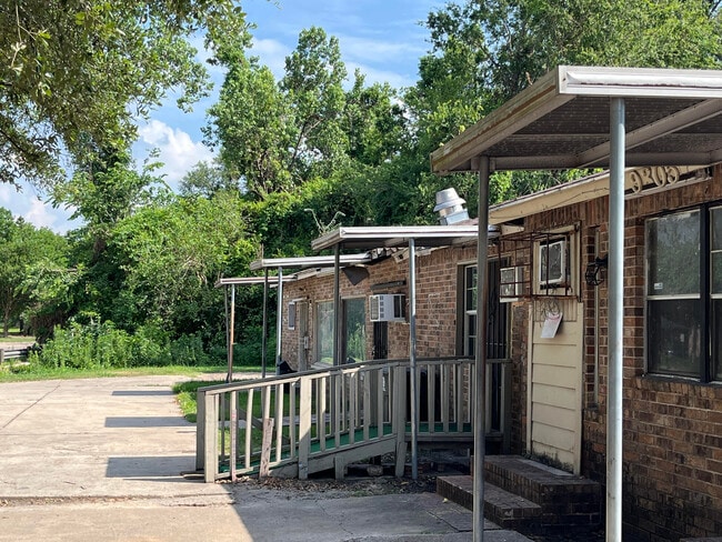
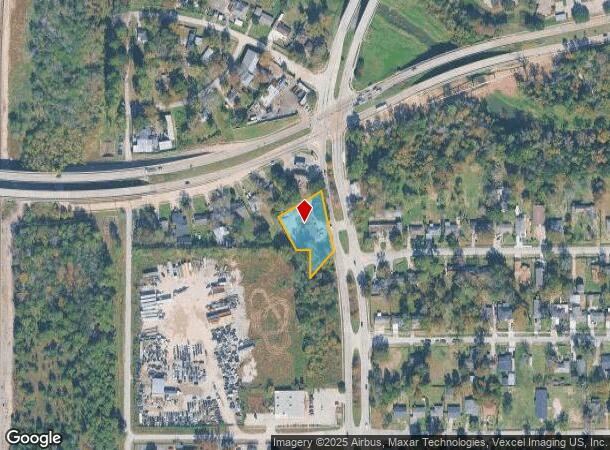
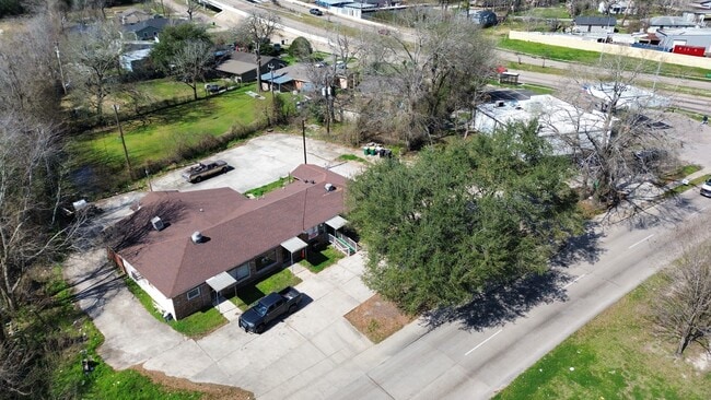
This Property Is For Sale
NEARBY LISTINGS FOR SALE OR LEASE
Property Detail
9305 N Wayside Dr
0761180300466
Parkhurst Estates
Storebuilding
TR 466 BLK 30 PARKHURST ESTATES SEC 3
X
Harris
48201C0685L
Texas
2024
0.49 AC
2025
Northeast Near
231000
Houston
3,568 SF
Houston-The Woodlands-Sugar Land, TX
DEMOGRAPHICS near 9305 N Wayside Dr
1 Mile
3 Mile
5 Mile
2024 Total Population
12,632
72,539
191,365
2029 Population
13,196
75,233
196,638
Pop Growth 2024-2029
+ 4.46%
+ 3.71%
+ 2.76%
Average Age
38
37
36
2024 Total Households
4,128
23,278
59,459
HH Growth 2024-2029
+ 4.29%
+ 3.60%
+ 2.74%
Median Household Inc
$37,368
$33,758
$35,441
Avg Household Size
3.00
3.00
3.10
2024 Avg HH Vehicles
2.00
2.00
2.00
Median Home Value
$84,839
$93,922
$111,653
Median Year Built
1970
1967
1967
Nearby Places
Map Layers
Map Styles
 Street
 Aerial
- Restaurants
- Banks
- Shops
- Fitness
- Groceries
PUBLIC TRANSPORTATION
AIRPORT
George Bush Intcntl/Houston
DRIVE
WALK
Distance
George Bush Intcntl/Houston
20 min
12.3 mi
William P Hobby
DRIVE
WALK
Distance
William P Hobby
30 min
17.4 mi
Freight Ports
Port of Houston
DRIVE
WALK
Distance
Port of Houston
17 min
9.4 mi
Nearby Properties
Address
Land Use
TOTAL SIZE
Lot Size
Zoning
Address
Land Use
TOTAL SIZE
Lot Size
Zoning
602,940 SF
30.90 AC
Address
Land Use
TOTAL SIZE
Lot Size
Zoning
228,576 SF
11.46 AC
Address
Land Use
TOTAL SIZE
Lot Size
Zoning
357,510 SF
29.15 AC
Address
Land Use
TOTAL SIZE
Lot Size
Zoning
438,196 SF
89.88 AC
Address
Land Use
TOTAL SIZE
Lot Size
Zoning
214,200 SF
12.92 AC
Address
Land Use
TOTAL SIZE
Lot Size
Zoning
144,823 SF
80 AC
Address
Land Use
TOTAL SIZE
Lot Size
Zoning
215,705 SF
39.58 AC
Address
Land Use
TOTAL SIZE
Lot Size
Zoning
311,550 SF
12.49 AC
Address
Land Use
TOTAL SIZE
Lot Size
Zoning
150,632 SF
36.03 AC
Address
Land Use
TOTAL SIZE
Lot Size
Zoning
300,000 SF
12.83 AC
Address
Land Use
TOTAL SIZE
Lot Size
Zoning
261,327 SF
19.31 AC
Address
Land Use
TOTAL SIZE
Lot Size
Zoning
296,850 SF
20.04 AC
Address
Land Use
TOTAL SIZE
Lot Size
Zoning
411,028 SF
34.67 AC
Address
Land Use
TOTAL SIZE
Lot Size
Zoning
304,925 SF
10.91 AC
Address
Land Use
TOTAL SIZE
Lot Size
Zoning
199,340 SF
13.27 AC
Address
Land Use
TOTAL SIZE
Lot Size
Zoning
91,623 SF
9.09 AC
Address
Land Use
TOTAL SIZE
Lot Size
Zoning
138,600 SF
12.29 AC
Address
Land Use
TOTAL SIZE
Lot Size
Zoning
219,230 SF
9.92 AC
Address
Land Use
TOTAL SIZE
Lot Size
Zoning
254,496 SF
18.22 AC
Address
Land Use
TOTAL SIZE
Lot Size
Zoning
55,517 SF
13 AC
Address
Land Use
TOTAL SIZE
Lot Size
Zoning
132,800 SF
8 AC
Address
Land Use
TOTAL SIZE
Lot Size
Zoning
163,424 SF
8.74 AC
Address
Land Use
TOTAL SIZE
Lot Size
Zoning
162,200 SF
6.72 AC
Address
Land Use
TOTAL SIZE
Lot Size
Zoning
385,950 SF
28.31 AC
Address
Land Use
TOTAL SIZE
Lot Size
Zoning
1,500 SF
106.21 AC
Address
Land Use
TOTAL SIZE
Lot Size
Zoning
102,214 SF
11.26 AC
Address
Land Use
TOTAL SIZE
Lot Size
Zoning
103,817 SF
11.29 AC
Address
Land Use
TOTAL SIZE
Lot Size
Zoning
66,452 SF
6 AC
Address
Land Use
TOTAL SIZE
Lot Size
Zoning
288,992 SF
6.56 AC
Address
Land Use
TOTAL SIZE
Lot Size
Zoning
164,377 SF
32.46 AC
The World's #1 Commercial Real Estate Marketplace
Connect with us
© 2025 CoStar Group
The information above has been obtained from sources believed reliable. While we do not doubt its accuracy we have not verified it and make no guarantee, warranty or representation about it. It is your responsibility to independently confirm its accuracy and completeness. Any projections, opinions, assumptions, or estimates used are for example only and do not represent the current or future performance of the property. The value of this transaction to you depends on tax and other factors which should be evaluated by your tax, financial, and legal advisors. You and your advisors should conduct a careful, independent investigation of the property to determine to your satisfaction the suitability of the property for your needs.