Property Record
9305 Pocahontas Trl, Williamsburg, VA 23185

NEARBY LISTINGS FOR SALE OR LEASE
-
-
View all Williamsburg listings for sale on LoopNet.com
Property Detail
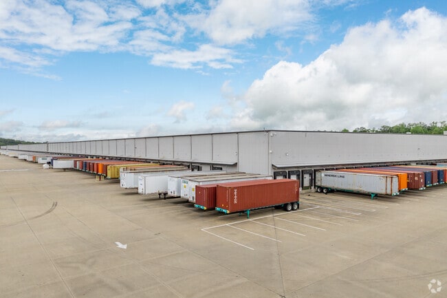
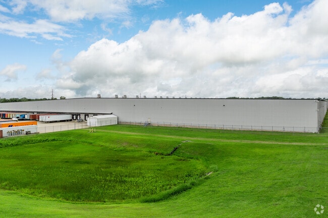
9305 Pocahontas Trl
Virginia Beach-Norfolk-Newport News, VA-NC
Green Mount Industrial Park
60-1-01-0-0010
LOT 2 GREEN MOUNT ASSOCIATES *WAS (60-1)(01-0-0004-)
Commercialnec
James City
AE
Virginia
51095C0228D
2
2025
410.35 AC
2025
Williamsburg Extended
080102
Hampton Roads
1,017,298 SF
DEMOGRAPHICS near 9305 Pocahontas Trl
1 Mile
3 Mile
5 Mile
2024 Total Population
1,495
13,942
46,754
2029 Population
1,562
14,349
47,486
Pop Growth 2024-2029
+ 4.48%
+ 2.92%
+ 1.57%
Average Age
37
34
35
2024 Total Households
582
4,691
16,790
HH Growth 2024-2029
+ 3.95%
+ 2.71%
+ 1.52%
Median Household Inc
$65,718
$68,330
$66,099
Avg Household Size
2.40
2.60
2.60
2024 Avg HH Vehicles
2.00
2.00
2.00
Median Home Value
$183,192
$206,714
$253,027
Median Year Built
1988
1992
1989
Nearby Places
Map Layers
Map Styles
 Street
 Aerial
- Restaurants
- Banks
- Shops
- Fitness
- Groceries
PUBLIC TRANSPORTATION
COMMUTER RAIL
DRIVE
WALK
Distance
21 min
9.0 mi
DRIVE
WALK
Distance
15 min
9.5 mi
AIRPORT
Newport News/Williamsburg International
DRIVE
WALK
Distance
Newport News/Williamsburg International
22 min
10.7 mi
Norfolk International
DRIVE
WALK
Distance
Norfolk International
54 min
36.9 mi
Freight Ports
Virginia Port Authority - Newport News
DRIVE
WALK
Distance
Virginia Port Authority - Newport News
35 min
24.7 mi
Nearby Properties
Address
Land Use
TOTAL SIZE
Lot Size
Zoning
Address
Land Use
TOTAL SIZE
Lot Size
Zoning
67,766 SF
7,722.51 AC
R1
Address
Land Use
TOTAL SIZE
Lot Size
Zoning
0.19 AC
R1
Address
Land Use
TOTAL SIZE
Lot Size
Zoning
7,825 SF
0.03 AC
P1
Address
Land Use
TOTAL SIZE
Lot Size
Zoning
45,382 SF
109.90 AC
M2
Address
Land Use
TOTAL SIZE
Lot Size
Zoning
4,815 SF
37.84 AC
PL PUBLIC
Address
Land Use
TOTAL SIZE
Lot Size
Zoning
63.87 AC
R8
Address
Land Use
TOTAL SIZE
Lot Size
Zoning
285 AC
R9
Address
Land Use
TOTAL SIZE
Lot Size
Zoning
100 SF
6.90 AC
R7
Address
Land Use
TOTAL SIZE
Lot Size
Zoning
300,649 SF
42.90 AC
M2
Address
Land Use
TOTAL SIZE
Lot Size
Zoning
166,196 SF
15.26 AC
PL PUBLIC
Address
Land Use
TOTAL SIZE
Lot Size
Zoning
372,600 SF
34.54 AC
M2 GENERAL
Address
Land Use
TOTAL SIZE
Lot Size
Zoning
15.60 AC
R7
Address
Land Use
TOTAL SIZE
Lot Size
Zoning
151,883 SF
25.31 AC
M2
Address
Land Use
TOTAL SIZE
Lot Size
Zoning
260,283 SF
19.98 AC
M2
Address
Land Use
TOTAL SIZE
Lot Size
Zoning
275,512 SF
30.03 AC
M1
Address
Land Use
TOTAL SIZE
Lot Size
Zoning
237,467 SF
28.93 AC
M2 GENERAL
Address
Land Use
TOTAL SIZE
Lot Size
Zoning
7.62 AC
R7
Address
Land Use
TOTAL SIZE
Lot Size
Zoning
143.61 AC
R9
Address
Land Use
TOTAL SIZE
Lot Size
Zoning
66,140 SF
20 AC
M2
Address
Land Use
TOTAL SIZE
Lot Size
Zoning
33,115 SF
5.89 AC
M2
Address
Land Use
TOTAL SIZE
Lot Size
Zoning
5.76 AC
R7
Address
Land Use
TOTAL SIZE
Lot Size
Zoning
625 AC
PL PUBLIC
Address
Land Use
TOTAL SIZE
Lot Size
Zoning
42,704 SF
30.30 AC
R5
Address
Land Use
TOTAL SIZE
Lot Size
Zoning
328,535 SF
51.05 AC
M2 GENERAL
Address
Land Use
TOTAL SIZE
Lot Size
Zoning
115,327 SF
15 AC
M2
Address
Land Use
TOTAL SIZE
Lot Size
Zoning
1,634 SF
96.90 AC
P1
Address
Land Use
TOTAL SIZE
Lot Size
Zoning
401.64 AC
P1
Address
Land Use
TOTAL SIZE
Lot Size
Zoning
77.15 AC
R8 RURAL R
Address
Land Use
TOTAL SIZE
Lot Size
Zoning
124,676 SF
21.07 AC
M2
The World's #1 Commercial Real Estate Marketplace
Connect with us
© 2026 CoStar Group
The information above has been obtained from sources believed reliable. While we do not doubt its accuracy we have not verified it and make no guarantee, warranty or representation about it. It is your responsibility to independently confirm its accuracy and completeness. Any projections, opinions, assumptions, or estimates used are for example only and do not represent the current or future performance of the property. The value of this transaction to you depends on tax and other factors which should be evaluated by your tax, financial, and legal advisors. You and your advisors should conduct a careful, independent investigation of the property to determine to your satisfaction the suitability of the property for your needs.