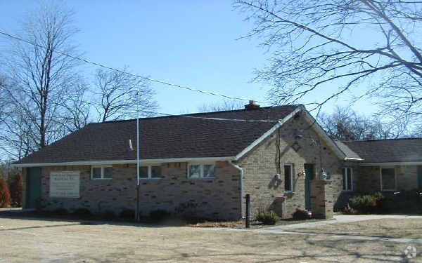
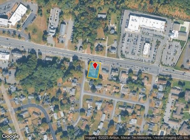
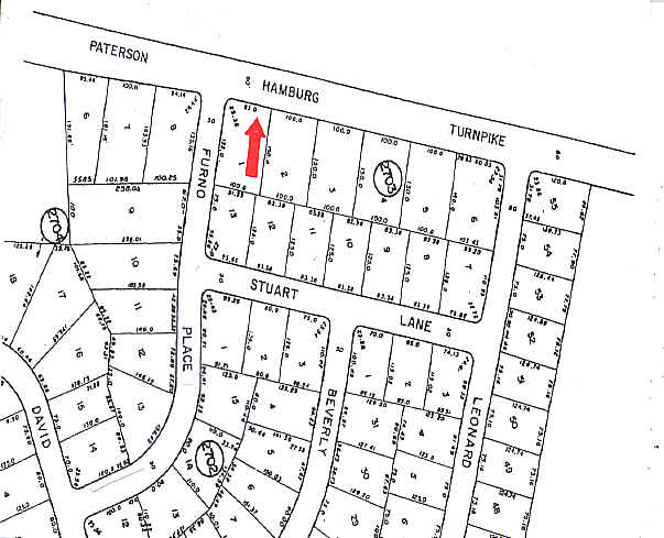
Property Record
931 Hamburg Tpke, Wayne, NJ 07470
NEARBY LISTINGS FOR SALE OR LEASE
Property Detail
931 Hamburg Tpke
14-02703-0000-00001
Passaic
Medicalbuilding
New Jersey
X
1
34031C0203G
0.34 AC
2024
Passaic Rt 46/23
2025
Northern New Jersey
246103
New York-Jersey City-White Plains, NY-NJ
1,508 SF
DEMOGRAPHICS near 931 Hamburg Tpke
1 Mile
3 Mile
5 Mile
2024 Total Population
9,535
72,394
281,290
2029 Population
9,430
71,803
275,481
Pop Growth 2024-2029
(1.10%)
(0.82%)
(2.07%)
Average Age
43
42
40
2024 Total Households
4,085
24,698
95,775
HH Growth 2024-2029
(1.40%)
(1.03%)
(2.13%)
Median Household Inc
$93,245
$126,941
$90,357
Avg Household Size
2.30
2.80
2.80
2024 Avg HH Vehicles
2.00
2.00
2.00
Median Home Value
$536,570
$574,915
$485,445
Median Year Built
1976
1966
1960
Nearby Places
Map Layers
Map Styles
 Street
 Aerial
- Restaurants
- Banks
- Shops
- Fitness
- Groceries
PUBLIC TRANSPORTATION
COMMUTER RAIL
Wayne/Route 23 Transit Center (Montclair-Boonton Line - NJ Transit Commuter Rail (NJ Transit))
DRIVE
WALK
Distance
Wayne/Route 23 Transit Center (Montclair-Boonton Line - NJ Transit Commuter Rail (NJ Transit))
10 min
5.1 mi
Mountain View (Montclair-Boonton Line - NJ Transit Commuter Rail (NJ Transit))
DRIVE
WALK
Distance
Mountain View (Montclair-Boonton Line - NJ Transit Commuter Rail (NJ Transit))
11 min
5.2 mi
AIRPORT
Newark Liberty International
DRIVE
WALK
Distance
Newark Liberty International
33 min
25.5 mi
LaGuardia
DRIVE
WALK
Distance
LaGuardia
45 min
28.9 mi
Westchester County
DRIVE
WALK
Distance
Westchester County
65 min
46.4 mi
Freight Ports
Maher Terminal
DRIVE
WALK
Distance
Maher Terminal
40 min
25.4 mi
Nearby Properties
Address
Land Use
TOTAL SIZE
Lot Size
Zoning
Address
Land Use
TOTAL SIZE
Lot Size
Zoning
45,000 SF
124.04 AC
R-A
Address
Land Use
TOTAL SIZE
Lot Size
Zoning
18.76 AC
C-3
Address
Land Use
TOTAL SIZE
Lot Size
Zoning
84.08 AC
Address
Land Use
TOTAL SIZE
Lot Size
Zoning
19.20 AC
Address
Land Use
TOTAL SIZE
Lot Size
Zoning
1,482 SF
55.66 AC
R-B
Address
Land Use
TOTAL SIZE
Lot Size
Zoning
27.25 AC
Address
Land Use
TOTAL SIZE
Lot Size
Zoning
334,755 SF
107.89 AC
Address
Land Use
TOTAL SIZE
Lot Size
Zoning
220,994 SF
16.48 AC
Address
Land Use
TOTAL SIZE
Lot Size
Zoning
21.82 AC
Address
Land Use
TOTAL SIZE
Lot Size
Zoning
186,299 SF
2.16 AC
R-A
Address
Land Use
TOTAL SIZE
Lot Size
Zoning
79,562 SF
10.33 AC
AHO3
Address
Land Use
TOTAL SIZE
Lot Size
Zoning
145,949 SF
50 AC
Address
Land Use
TOTAL SIZE
Lot Size
Zoning
277,661 SF
50.20 AC
Address
Land Use
TOTAL SIZE
Lot Size
Zoning
63,460 SF
10.72 AC
Address
Land Use
TOTAL SIZE
Lot Size
Zoning
259,919 SF
48.14 AC
Address
Land Use
TOTAL SIZE
Lot Size
Zoning
9.08 AC
H-C
Address
Land Use
TOTAL SIZE
Lot Size
Zoning
25.80 AC
Address
Land Use
TOTAL SIZE
Lot Size
Zoning
13.61 AC
Address
Land Use
TOTAL SIZE
Lot Size
Zoning
55,035 SF
34.48 AC
R-A
Address
Land Use
TOTAL SIZE
Lot Size
Zoning
1,824 SF
243 AC
R-B
Address
Land Use
TOTAL SIZE
Lot Size
Zoning
4.94 AC
Address
Land Use
TOTAL SIZE
Lot Size
Zoning
7,398 SF
13.96 AC
Address
Land Use
TOTAL SIZE
Lot Size
Zoning
1,600 SF
11.60 AC
OB
Address
Land Use
TOTAL SIZE
Lot Size
Zoning
1,197.68 AC
Address
Land Use
TOTAL SIZE
Lot Size
Zoning
Address
Land Use
TOTAL SIZE
Lot Size
Zoning
145,904 SF
14.20 AC
IP
Address
Land Use
TOTAL SIZE
Lot Size
Zoning
1.54 AC
Address
Land Use
TOTAL SIZE
Lot Size
Zoning
2,511 SF
17.63 AC
Address
Land Use
TOTAL SIZE
Lot Size
Zoning
89,728 SF
5.83 AC
R-A
Address
Land Use
TOTAL SIZE
Lot Size
Zoning
3.94 AC
The World's #1 Commercial Real Estate Marketplace
Connect with us
© 2025 CoStar Group
The information above has been obtained from sources believed reliable. While we do not doubt its accuracy we have not verified it and make no guarantee, warranty or representation about it. It is your responsibility to independently confirm its accuracy and completeness. Any projections, opinions, assumptions, or estimates used are for example only and do not represent the current or future performance of the property. The value of this transaction to you depends on tax and other factors which should be evaluated by your tax, financial, and legal advisors. You and your advisors should conduct a careful, independent investigation of the property to determine to your satisfaction the suitability of the property for your needs.