Property Record
9390 E Mclellan Rd, Mesa, AZ 85207
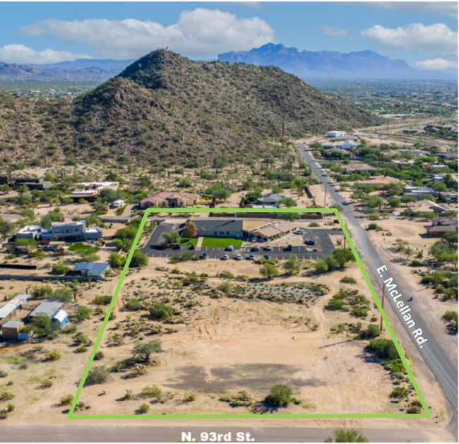
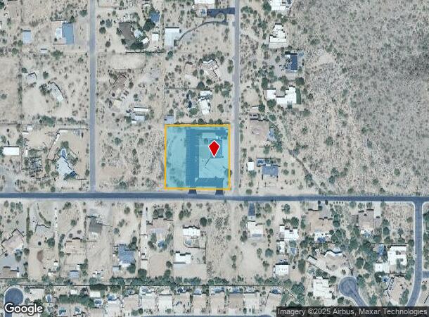
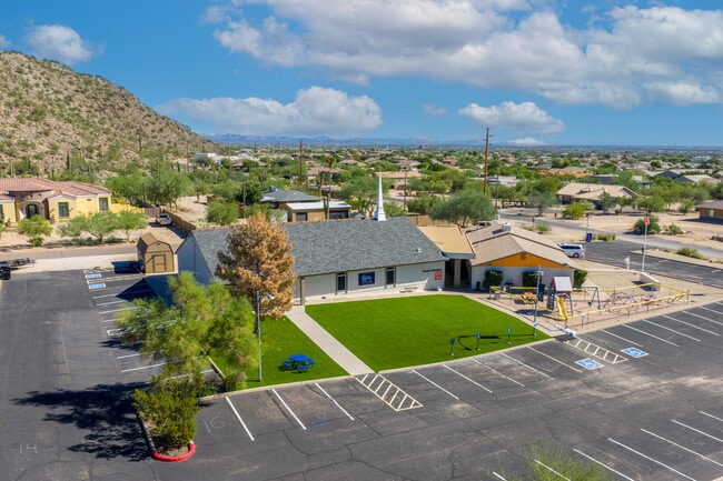
This Property Is For Sale
NEARBY LISTINGS FOR SALE OR LEASE
-
-
View all Mesa listings for sale on LoopNet.com
Property Detail
9390 E Mclellan Rd
220-01-003Y
SE4 SE4 SW4 NW4 EX S 40F & EX E 30F RDS
Religious
Maricopa
X
Arizona
04013C2285L
2 AC
0
Mesa East
2025
Phoenix
420110
Phoenix-Mesa-Chandler, AZ
7,006 SF
DEMOGRAPHICS near 9390 E Mclellan Rd
1 Mile
3 Mile
5 Mile
2024 Total Population
7,887
63,845
188,942
2029 Population
8,294
67,115
200,816
Pop Growth 2024-2029
+ 5.16%
+ 5.12%
+ 6.28%
Average Age
45
43
46
2024 Total Households
2,929
24,489
78,755
HH Growth 2024-2029
+ 5.26%
+ 5.30%
+ 6.58%
Median Household Inc
$133,588
$80,395
$76,032
Avg Household Size
2.60
2.50
2.30
2024 Avg HH Vehicles
2.00
2.00
2.00
Median Home Value
$676,234
$413,708
$382,378
Median Year Built
2004
1995
1993
Nearby Places
Map Layers
Map Styles
 Street
 Aerial
- Restaurants
- Banks
- Shops
- Fitness
- Groceries
PUBLIC TRANSPORTATION
AIRPORT
Phoenix-Mesa Gateway
DRIVE
WALK
Distance
Phoenix-Mesa Gateway
20 min
13.1 mi
Phoenix Sky Harbor International
DRIVE
WALK
Distance
Phoenix Sky Harbor International
34 min
25.3 mi
Freight Ports
Port of San Diego
DRIVE
WALK
Distance
Port of San Diego
425 min
385.7 mi
Nearby Properties
Address
Land Use
TOTAL SIZE
Lot Size
Zoning
Address
Land Use
TOTAL SIZE
Lot Size
Zoning
57.25 AC
PF
Address
Land Use
TOTAL SIZE
Lot Size
Zoning
324,534 SF
50.86 AC
PF
Address
Land Use
TOTAL SIZE
Lot Size
Zoning
244,351 SF
18.46 AC
RS43
Address
Land Use
TOTAL SIZE
Lot Size
Zoning
172,756 SF
8.52 AC
LC
Address
Land Use
TOTAL SIZE
Lot Size
Zoning
82,772 SF
131.12 AC
PF
Address
Land Use
TOTAL SIZE
Lot Size
Zoning
267,380 SF
17.08 AC
M-H
Address
Land Use
TOTAL SIZE
Lot Size
Zoning
124,850 SF
12.09 AC
RM4
Address
Land Use
TOTAL SIZE
Lot Size
Zoning
87,423 SF
9.43 AC
C-G
Address
Land Use
TOTAL SIZE
Lot Size
Zoning
52,500 SF
16.04 AC
PF
Address
Land Use
TOTAL SIZE
Lot Size
Zoning
105,417 SF
12.18 AC
C-G
Address
Land Use
TOTAL SIZE
Lot Size
Zoning
342,294 SF
7.25 AC
RM4
Address
Land Use
TOTAL SIZE
Lot Size
Zoning
185,850 SF
8.94 AC
M-H
Address
Land Use
TOTAL SIZE
Lot Size
Zoning
63,601 SF
12.81 AC
R-43
Address
Land Use
TOTAL SIZE
Lot Size
Zoning
69,267 SF
13.20 AC
PF
Address
Land Use
TOTAL SIZE
Lot Size
Zoning
68,011 SF
9.63 AC
R-7
Address
Land Use
TOTAL SIZE
Lot Size
Zoning
92,674 SF
8.99 AC
CS
Address
Land Use
TOTAL SIZE
Lot Size
Zoning
88,989 SF
2.21 AC
M-H
Address
Land Use
TOTAL SIZE
Lot Size
Zoning
37,453 SF
45.57 AC
AG
Address
Land Use
TOTAL SIZE
Lot Size
Zoning
127,858 SF
12.89 AC
R18
Address
Land Use
TOTAL SIZE
Lot Size
Zoning
3,900 SF
623.74 AC
R-70
Address
Land Use
TOTAL SIZE
Lot Size
Zoning
279,462 SF
8.69 AC
M-H
Address
Land Use
TOTAL SIZE
Lot Size
Zoning
6,432 SF
34.41 AC
PF
Address
Land Use
TOTAL SIZE
Lot Size
Zoning
60,217 SF
10.88 AC
M-H
Address
Land Use
TOTAL SIZE
Lot Size
Zoning
90,092 SF
8.50 AC
C-G
Address
Land Use
TOTAL SIZE
Lot Size
Zoning
34,432 SF
5.36 AC
PF
Address
Land Use
TOTAL SIZE
Lot Size
Zoning
33,565 SF
6.30 AC
R-35
Address
Land Use
TOTAL SIZE
Lot Size
Zoning
32,389 SF
4.18 AC
R-43
Address
Land Use
TOTAL SIZE
Lot Size
Zoning
0.93 AC
C-G
Address
Land Use
TOTAL SIZE
Lot Size
Zoning
80,180 SF
10.40 AC
Address
Land Use
TOTAL SIZE
Lot Size
Zoning
47,171 SF
10.46 AC
RU-43
The World's #1 Commercial Real Estate Marketplace
Connect with us
© 2026 CoStar Group
The information above has been obtained from sources believed reliable. While we do not doubt its accuracy we have not verified it and make no guarantee, warranty or representation about it. It is your responsibility to independently confirm its accuracy and completeness. Any projections, opinions, assumptions, or estimates used are for example only and do not represent the current or future performance of the property. The value of this transaction to you depends on tax and other factors which should be evaluated by your tax, financial, and legal advisors. You and your advisors should conduct a careful, independent investigation of the property to determine to your satisfaction the suitability of the property for your needs.