Property Record
932 W Eldorado St, Decatur, IL 62522
NEARBY LISTINGS FOR SALE OR LEASE
Property Detail
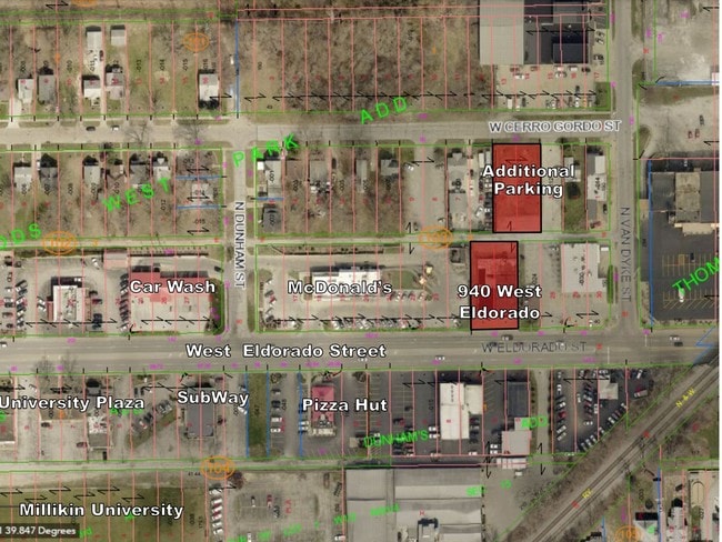
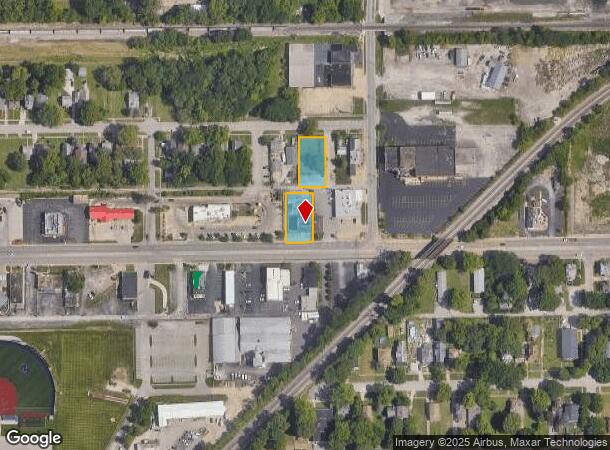
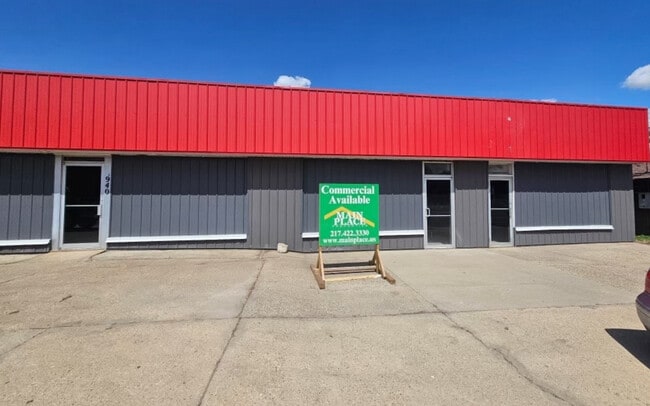
932 W Eldorado St
Decatur, IL
H A Woods West Park Add
04-12-15-103-028
H A WOODS WEST ~PARK ADD OF O L ~LOTS 25 & 26 B 4 ~L 4 & 5 95BK2619/300 IRREG ~58 04 2 52 0486 000 00
Commercialnec
Macon
X
Illinois
17115C0301E
25-26
2024
0.55 AC
2024
Springfield/Decatur
001600
Other Market Areas
DEMOGRAPHICS near 932 W Eldorado St
1 Mile
3 Mile
5 Mile
2024 Total Population
13,624
50,743
75,230
2029 Population
13,612
49,906
73,430
Pop Growth 2024-2029
(0.09%)
(1.65%)
(2.39%)
Average Age
36
40
41
2024 Total Households
5,484
21,848
32,890
HH Growth 2024-2029
+ 0.09%
(1.72%)
(2.49%)
Median Household Inc
$30,263
$39,046
$43,193
Avg Household Size
2.10
2.10
2.10
2024 Avg HH Vehicles
1.00
1.00
2.00
Median Home Value
$69,218
$77,703
$91,940
Median Year Built
1948
1955
1960
Nearby Places
Map Layers
Map Styles
 Street
 Aerial
- Restaurants
- Banks
- Shops
- Fitness
- Groceries
SALE & LEASE HISTORY
LISTING DATE
SALE/LEASE

May 01, 2017
For Lease
Mar 23, 2023
For Sale
Feb 11, 2025
For Sale
Aug 24, 2022
For Sale
Nearby Properties
Address
Land Use
TOTAL SIZE
Lot Size
Zoning
Address
Land Use
TOTAL SIZE
Lot Size
Zoning
1.03 AC
MUNICIPAL
Address
Land Use
TOTAL SIZE
Lot Size
Zoning
1.40 AC
MUNICIPAL
Address
Land Use
TOTAL SIZE
Lot Size
Zoning
6.60 AC
MUNICIPAL
Address
Land Use
TOTAL SIZE
Lot Size
Zoning
Address
Land Use
TOTAL SIZE
Lot Size
Zoning
6.68 AC
MUNICIPAL
Address
Land Use
TOTAL SIZE
Lot Size
Zoning
18.50 AC
MUNICIPAL
Address
Land Use
TOTAL SIZE
Lot Size
Zoning
6.89 AC
MUNICIPAL
Address
Land Use
TOTAL SIZE
Lot Size
Zoning
19.95 AC
MUNICIPAL
Address
Land Use
TOTAL SIZE
Lot Size
Zoning
7.82 AC
MUNICIPAL
Address
Land Use
TOTAL SIZE
Lot Size
Zoning
3.35 AC
MUNICIPAL
Address
Land Use
TOTAL SIZE
Lot Size
Zoning
1.72 AC
MUNICIPAL
Address
Land Use
TOTAL SIZE
Lot Size
Zoning
1.10 AC
MUNICIPAL
Address
Land Use
TOTAL SIZE
Lot Size
Zoning
78.13 AC
MUNICIPAL
Address
Land Use
TOTAL SIZE
Lot Size
Zoning
6.35 AC
MUNICIPAL
Address
Land Use
TOTAL SIZE
Lot Size
Zoning
3.93 AC
MUNICIPAL
Address
Land Use
TOTAL SIZE
Lot Size
Zoning
14.33 AC
MUNICIPAL
Address
Land Use
TOTAL SIZE
Lot Size
Zoning
54.49 AC
MUNICIPAL
Address
Land Use
TOTAL SIZE
Lot Size
Zoning
4.30 AC
MUNICIPAL
Address
Land Use
TOTAL SIZE
Lot Size
Zoning
0.97 AC
MUNICIPAL
Address
Land Use
TOTAL SIZE
Lot Size
Zoning
3.50 AC
MUNICIPAL
Address
Land Use
TOTAL SIZE
Lot Size
Zoning
1.73 AC
MUNICIPAL
Address
Land Use
TOTAL SIZE
Lot Size
Zoning
14.76 AC
MUNICIPAL
Address
Land Use
TOTAL SIZE
Lot Size
Zoning
3.86 AC
MUNICIPAL
Address
Land Use
TOTAL SIZE
Lot Size
Zoning
14.80 AC
MUNICIPAL
Address
Land Use
TOTAL SIZE
Lot Size
Zoning
Address
Land Use
TOTAL SIZE
Lot Size
Zoning
2.62 AC
MUNICIPAL
Address
Land Use
TOTAL SIZE
Lot Size
Zoning
9.11 AC
MUNICIPAL
Address
Land Use
TOTAL SIZE
Lot Size
Zoning
35.07 AC
MUNICIPAL
Address
Land Use
TOTAL SIZE
Lot Size
Zoning
4.21 AC
MUNICIPAL
The World's #1 Commercial Real Estate Marketplace
Connect with us
© 2025 CoStar Group
The information above has been obtained from sources believed reliable. While we do not doubt its accuracy we have not verified it and make no guarantee, warranty or representation about it. It is your responsibility to independently confirm its accuracy and completeness. Any projections, opinions, assumptions, or estimates used are for example only and do not represent the current or future performance of the property. The value of this transaction to you depends on tax and other factors which should be evaluated by your tax, financial, and legal advisors. You and your advisors should conduct a careful, independent investigation of the property to determine to your satisfaction the suitability of the property for your needs.