Property Record
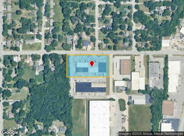
9320 W 53Rd Ter, Shawnee, KS 66203
NEARBY LISTINGS FOR SALE OR LEASE
Property Detail
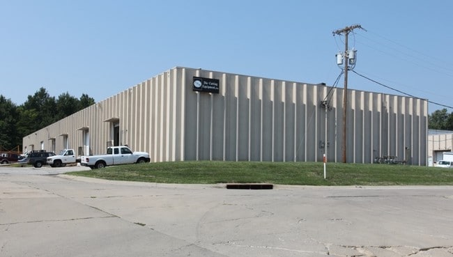
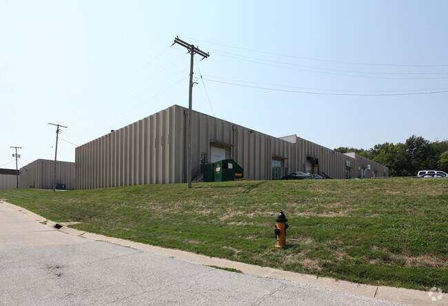
9320 W 53Rd Ter
JF241201-4058
1-12-24 BG 30' S NW CR SW1/4 SE1/4 S 224.17' E 431.51' N 207.23' NWLY CUR LF 31.42' TO PT ON S RTWY/L 53RD ST W 412.18' TO POB 2.235 ACS M/L MEC 33 3 1 1
Warehouse
Johnson
X
Kansas
20209C0165D
2.21 AC
2024
Merriam/Mission
2024
Kansas City
052201
Kansas City, MO-KS
30,000 SF
DEMOGRAPHICS near 9320 W 53Rd Ter
1 Mile
3 Mile
5 Mile
2024 Total Population
8,389
73,428
191,398
2029 Population
8,623
75,017
196,074
Pop Growth 2024-2029
+ 2.79%
+ 2.16%
+ 2.44%
Average Age
40
40
40
2024 Total Households
3,367
31,973
82,686
HH Growth 2024-2029
+ 2.91%
+ 2.55%
+ 2.70%
Median Household Inc
$76,683
$68,663
$72,357
Avg Household Size
2.40
2.20
2.30
2024 Avg HH Vehicles
2.00
2.00
2.00
Median Home Value
$223,798
$224,815
$259,356
Median Year Built
1968
1965
1966
Nearby Places
Map Layers
Map Styles
 Street
 Aerial
- Restaurants
- Banks
- Shops
- Fitness
- Groceries
PUBLIC TRANSPORTATION
COMMUTER RAIL
Kansas City (Lincoln Service Missouri River Runner - Amtrak, Missouri River Runner - Amtrak, Southwest Chief - Amtrak)
DRIVE
WALK
Distance
Kansas City (Lincoln Service Missouri River Runner - Amtrak, Missouri River Runner - Amtrak, Southwest Chief - Amtrak)
15 min
9.1 mi
AIRPORT
Kansas City International
DRIVE
WALK
Distance
Kansas City International
34 min
25.2 mi
Freight Ports
Tulsa Port Of Catoosa
DRIVE
WALK
Distance
Tulsa Port Of Catoosa
258 min
230.6 mi
SALE & LEASE HISTORY
LISTING DATE
SALE/LEASE

Jul 09, 2018
For Lease
Nearby Properties
Address
Land Use
TOTAL SIZE
Lot Size
Zoning
Address
Land Use
TOTAL SIZE
Lot Size
Zoning
857,568 SF
38.48 AC
PUD-G
Address
Land Use
TOTAL SIZE
Lot Size
Zoning
202,842 SF
10.20 AC
PD
Address
Land Use
TOTAL SIZE
Lot Size
Zoning
312,446 SF
39.35 AC
R-1
Address
Land Use
TOTAL SIZE
Lot Size
Zoning
249,363 SF
58.59 AC
Address
Land Use
TOTAL SIZE
Lot Size
Zoning
133,505 SF
16.41 AC
R-1
Address
Land Use
TOTAL SIZE
Lot Size
Zoning
96,501 SF
6.49 AC
Address
Land Use
TOTAL SIZE
Lot Size
Zoning
89,477 SF
16.45 AC
R-1
Address
Land Use
TOTAL SIZE
Lot Size
Zoning
42,597 SF
4.39 AC
MS2
Address
Land Use
TOTAL SIZE
Lot Size
Zoning
75,010 SF
5.53 AC
PD
Address
Land Use
TOTAL SIZE
Lot Size
Zoning
63,471 SF
7.36 AC
PARK
Address
Land Use
TOTAL SIZE
Lot Size
Zoning
90,774 SF
1.73 AC
MS2
Address
Land Use
TOTAL SIZE
Lot Size
Zoning
85,940 SF
9.08 AC
RGA
Address
Land Use
TOTAL SIZE
Lot Size
Zoning
96,856 SF
15.76 AC
R-1
Address
Land Use
TOTAL SIZE
Lot Size
Zoning
30,143 SF
18.61 AC
KRP6
Address
Land Use
TOTAL SIZE
Lot Size
Zoning
100,090 SF
48.47 AC
KR1
Address
Land Use
TOTAL SIZE
Lot Size
Zoning
93,418 SF
12.07 AC
R-1
Address
Land Use
TOTAL SIZE
Lot Size
Zoning
81,361 SF
3.81 AC
AG
Address
Land Use
TOTAL SIZE
Lot Size
Zoning
37,499 SF
3.72 AC
PUD-G
Address
Land Use
TOTAL SIZE
Lot Size
Zoning
70,952 SF
9.98 AC
R-1
Address
Land Use
TOTAL SIZE
Lot Size
Zoning
100,784 SF
4.68 AC
C-2B
Address
Land Use
TOTAL SIZE
Lot Size
Zoning
74,212 SF
8.01 AC
R-1
Address
Land Use
TOTAL SIZE
Lot Size
Zoning
21,635 SF
10.75 AC
KRP5
Address
Land Use
TOTAL SIZE
Lot Size
Zoning
74,802 SF
10.55 AC
CP-O
Address
Land Use
TOTAL SIZE
Lot Size
Zoning
24,920 SF
7.84 AC
KRP5
Address
Land Use
TOTAL SIZE
Lot Size
Zoning
77,758 SF
4.89 AC
R-1
Address
Land Use
TOTAL SIZE
Lot Size
Zoning
311,454 SF
40.91 AC
PUD-G
Address
Land Use
TOTAL SIZE
Lot Size
Zoning
667,586 SF
18.06 AC
PUD-G
Address
Land Use
TOTAL SIZE
Lot Size
Zoning
13,210 SF
7.80 AC
KRP5
Address
Land Use
TOTAL SIZE
Lot Size
Zoning
34,745 SF
8.96 AC
PARK
Address
Land Use
TOTAL SIZE
Lot Size
Zoning
82,035 SF
8.49 AC
R-1
The World's #1 Commercial Real Estate Marketplace
Connect with us
© 2025 CoStar Group
The information above has been obtained from sources believed reliable. While we do not doubt its accuracy we have not verified it and make no guarantee, warranty or representation about it. It is your responsibility to independently confirm its accuracy and completeness. Any projections, opinions, assumptions, or estimates used are for example only and do not represent the current or future performance of the property. The value of this transaction to you depends on tax and other factors which should be evaluated by your tax, financial, and legal advisors. You and your advisors should conduct a careful, independent investigation of the property to determine to your satisfaction the suitability of the property for your needs.