Property Record
9321 Seward Rd, Fairfield, OH 45014
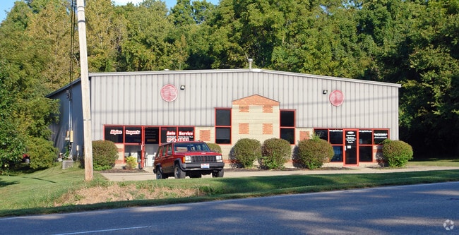

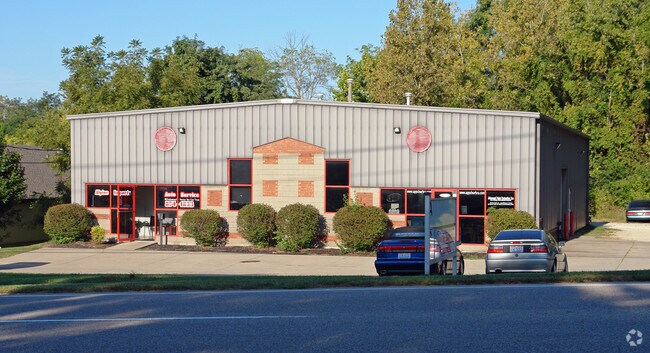
Property Detail
9321 Seward Rd
A0700-187-000-004
9379 N 100 SEE TIF PCL 004T - FF NORTHEAST-FAIRFIELD TIF
Storebuilding
Butler
B and X Area of moderate flood hazard, usually the area between the limits of the 100-year and 500-year floods.
Ohio
2024
1 AC
2025
Tri-County
010909
Cincinnati/Dayton
5,640 SF
Cincinnati, OH-KY-IN
NEARBY LISTINGS FOR SALE OR LEASE
DEMOGRAPHICS near 9321 Seward Rd
1 mile
3 mile
5 mile
2025 Total Population
2,695
56,546
165,168
2030 Population
2,780
58,052
168,466
Pop Growth 2025-2030
+ 3.15%
+ 2.66%
+ 2.00%
Average Age
39
39
40
2025 Total Households
1,110
22,586
63,938
HH Growth 2025-2030
+ 3.15%
+ 2.90%
+ 2.08%
Median Household Inc
$75,455
$72,539
$79,059
Avg Household Size
2.40
2.40
2.50
2025 Avg HH Vehicles
2.00
2.00
2.00
Median Home Value
$239,066
$225,005
$244,786
Median Year Built
1989
1981
1978
Nearby Places
Map Layers
Map Styles
 Street
 Aerial
Layers
 Traffic
 Biking
Places
Listings with unknown addresses are not visible on the map
- Restaurants
- Banks
- Shops
- Fitness
- Groceries
Nearby Properties
Address
Land Use
TOTAL SIZE
Lot Size
Zoning
Address
Land Use
TOTAL SIZE
Lot Size
Zoning
987,717 SF
57.32 AC
Address
Land Use
TOTAL SIZE
Lot Size
Zoning
61.62 AC
Address
Land Use
TOTAL SIZE
Lot Size
Zoning
1,398,190 SF
54.91 AC
Address
Land Use
TOTAL SIZE
Lot Size
Zoning
38,880 SF
20.93 AC
Address
Land Use
TOTAL SIZE
Lot Size
Zoning
28.80 AC
Address
Land Use
TOTAL SIZE
Lot Size
Zoning
54,055 SF
18.17 AC
Address
Land Use
TOTAL SIZE
Lot Size
Zoning
1,363,493 SF
75.28 AC
Address
Land Use
TOTAL SIZE
Lot Size
Zoning
559,332 SF
29.30 AC
Address
Land Use
TOTAL SIZE
Lot Size
Zoning
706,768 SF
35.92 AC
Address
Land Use
TOTAL SIZE
Lot Size
Zoning
914,426 SF
41.39 AC
Address
Land Use
TOTAL SIZE
Lot Size
Zoning
782,765 SF
33.15 AC
Address
Land Use
TOTAL SIZE
Lot Size
Zoning
510,080 SF
60.87 AC
Address
Land Use
TOTAL SIZE
Lot Size
Zoning
18.77 AC
Address
Land Use
TOTAL SIZE
Lot Size
Zoning
176,055 SF
31.46 AC
Address
Land Use
TOTAL SIZE
Lot Size
Zoning
498,300 SF
14.86 AC
Address
Land Use
TOTAL SIZE
Lot Size
Zoning
334,887 SF
16.16 AC
Address
Land Use
TOTAL SIZE
Lot Size
Zoning
26.63 AC
Address
Land Use
TOTAL SIZE
Lot Size
Zoning
39.89 AC
Address
Land Use
TOTAL SIZE
Lot Size
Zoning
467,263 SF
27.27 AC
ADV
Address
Land Use
TOTAL SIZE
Lot Size
Zoning
54.77 AC
Address
Land Use
TOTAL SIZE
Lot Size
Zoning
350,772 SF
23.62 AC
Address
Land Use
TOTAL SIZE
Lot Size
Zoning
31,930 SF
21.19 AC
Address
Land Use
TOTAL SIZE
Lot Size
Zoning
32,372 SF
32.90 AC
Address
Land Use
TOTAL SIZE
Lot Size
Zoning
567,230 SF
31.45 AC
Address
Land Use
TOTAL SIZE
Lot Size
Zoning
115,446 SF
20.08 AC
Address
Land Use
TOTAL SIZE
Lot Size
Zoning
2.24 AC
Address
Land Use
TOTAL SIZE
Lot Size
Zoning
438,182 SF
28.80 AC
Address
Land Use
TOTAL SIZE
Lot Size
Zoning
629,044 SF
35.83 AC
Address
Land Use
TOTAL SIZE
Lot Size
Zoning
25.89 AC
Address
Land Use
TOTAL SIZE
Lot Size
Zoning
482,499 SF
27.83 AC
The World's #1 Commercial Real Estate Marketplace
Connect with us
© 2026 CoStar Group
The information above has been obtained from sources believed reliable. While we do not doubt its accuracy we have not verified it and make no guarantee, warranty or representation about it. It is your responsibility to independently confirm its accuracy and completeness. Any projections, opinions, assumptions, or estimates used are for example only and do not represent the current or future performance of the property. The value of this transaction to you depends on tax and other factors which should be evaluated by your tax, financial, and legal advisors. You and your advisors should conduct a careful, independent investigation of the property to determine to your satisfaction the suitability of the property for your needs.