Property Record
933 State Highway 30, Mayfield, NY 12117
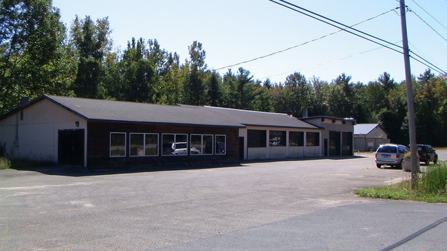

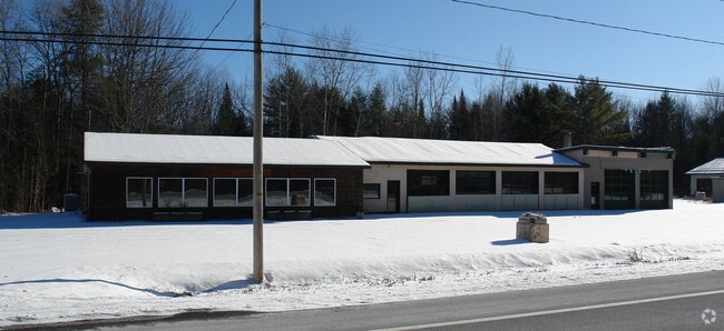
This Property Is For Sale
Current Lease Availabilities
NEARBY LISTINGS FOR SALE OR LEASE
Property Detail
933 State Highway 30
Gloversville, NY
Fulton
173289-045-002-0004-013-001-0000
New York
Storesoffices
13.001
2025
13 AC
2024
Fulton County
970100
Albany/Schenectady/Troy
8,948 SF
DEMOGRAPHICS near 933 State Highway 30
1 Mile
3 Mile
5 Mile
2024 Total Population
525
2,575
4,296
2029 Population
552
2,602
4,387
Pop Growth 2024-2029
+ 5.14%
+ 1.05%
+ 2.12%
Average Age
47
46
47
2024 Total Households
237
1,157
1,962
HH Growth 2024-2029
+ 5.06%
+ 1.04%
+ 2.19%
Median Household Inc
$51,842
$59,721
$61,939
Avg Household Size
2.20
2.20
2.20
2024 Avg HH Vehicles
2.00
2.00
2.00
Median Home Value
$251,999
$205,610
$217,435
Median Year Built
1981
1964
1970
Nearby Places
Map Layers
Map Styles
 Street
 Aerial
- Restaurants
- Banks
- Shops
- Fitness
- Groceries
Nearby Properties
Address
Land Use
TOTAL SIZE
Lot Size
Zoning
Address
Land Use
TOTAL SIZE
Lot Size
Zoning
117,749 SF
11.70 AC
Address
Land Use
TOTAL SIZE
Lot Size
Zoning
1,736 SF
33.95 AC
Address
Land Use
TOTAL SIZE
Lot Size
Zoning
1,188 SF
108.72 AC
OD
Address
Land Use
TOTAL SIZE
Lot Size
Zoning
0.85 AC
01 - NOT Z
Address
Land Use
TOTAL SIZE
Lot Size
Zoning
1,632 SF
32.77 AC
MD
Address
Land Use
TOTAL SIZE
Lot Size
Zoning
262.56 AC
07 - MIXED
Address
Land Use
TOTAL SIZE
Lot Size
Zoning
3,914 SF
7.34 AC
Address
Land Use
TOTAL SIZE
Lot Size
Zoning
2,850 SF
4.30 AC
Address
Land Use
TOTAL SIZE
Lot Size
Zoning
6,750 SF
Address
Land Use
TOTAL SIZE
Lot Size
Zoning
6,064 SF
0.78 AC
Address
Land Use
TOTAL SIZE
Lot Size
Zoning
0.46 AC
Address
Land Use
TOTAL SIZE
Lot Size
Zoning
2,742 SF
4.60 AC
Address
Land Use
TOTAL SIZE
Lot Size
Zoning
2,084 SF
2.80 AC
Address
Land Use
TOTAL SIZE
Lot Size
Zoning
5,118 SF
1.02 AC
01 - NOT Z
Address
Land Use
TOTAL SIZE
Lot Size
Zoning
3,568 SF
0.51 AC
Address
Land Use
TOTAL SIZE
Lot Size
Zoning
6,000 SF
0.62 AC
01 - NOT Z
Address
Land Use
TOTAL SIZE
Lot Size
Zoning
7,076 SF
0.54 AC
Address
Land Use
TOTAL SIZE
Lot Size
Zoning
13,770 SF
1.43 AC
Address
Land Use
TOTAL SIZE
Lot Size
Zoning
3,328 SF
0.26 AC
Address
Land Use
TOTAL SIZE
Lot Size
Zoning
4,576 SF
0.23 AC
R
Address
Land Use
TOTAL SIZE
Lot Size
Zoning
3,000 SF
0.76 AC
Address
Land Use
TOTAL SIZE
Lot Size
Zoning
2,472 SF
0.85 AC
RR
Address
Land Use
TOTAL SIZE
Lot Size
Zoning
2,280 SF
3.70 AC
C
Address
Land Use
TOTAL SIZE
Lot Size
Zoning
6,240 SF
0.52 AC
Address
Land Use
TOTAL SIZE
Lot Size
Zoning
2,408 SF
2.80 AC
RR
Address
Land Use
TOTAL SIZE
Lot Size
Zoning
5,576 SF
1.40 AC
Address
Land Use
TOTAL SIZE
Lot Size
Zoning
7,023 SF
0.40 AC
Address
Land Use
TOTAL SIZE
Lot Size
Zoning
1,994 SF
0.50 AC
Address
Land Use
TOTAL SIZE
Lot Size
Zoning
2,016 SF
35.15 AC
RR
Address
Land Use
TOTAL SIZE
Lot Size
Zoning
68,075 SF
54.10 AC
I
The World's #1 Commercial Real Estate Marketplace
Connect with us
© 2026 CoStar Group
The information above has been obtained from sources believed reliable. While we do not doubt its accuracy we have not verified it and make no guarantee, warranty or representation about it. It is your responsibility to independently confirm its accuracy and completeness. Any projections, opinions, assumptions, or estimates used are for example only and do not represent the current or future performance of the property. The value of this transaction to you depends on tax and other factors which should be evaluated by your tax, financial, and legal advisors. You and your advisors should conduct a careful, independent investigation of the property to determine to your satisfaction the suitability of the property for your needs.