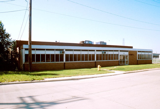
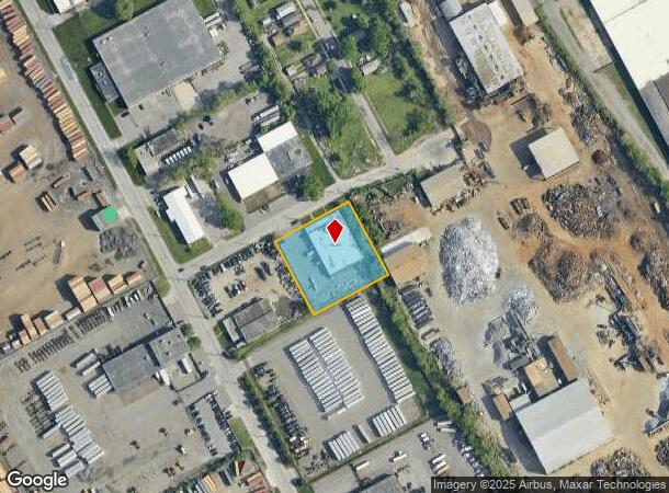
Property Record
9335 Saint Stephens St, Dearborn, MI 48126
NEARBY LISTINGS FOR SALE OR LEASE
Property Detail
9335 Saint Stephens St
Detroit-Warren-Dearborn, MI
Leho Industrial Acres
82-10-163-03-002
ELY 223 FT OF LOT 12 LEHO INDUSTRIAL ACRES
Warehouse
Wayne
X
Michigan
26163C0260E
12
2025
1.13 AC
2025
Downriver North
983600
Detroit
14,700 SF
DEMOGRAPHICS near 9335 Saint Stephens St
1 Mile
3 Mile
5 Mile
2024 Total Population
9,685
134,695
326,453
2029 Population
9,277
131,247
322,957
Pop Growth 2024-2029
(4.21%)
(2.56%)
(1.07%)
Average Age
31
34
36
2024 Total Households
2,574
42,751
120,541
HH Growth 2024-2029
(4.27%)
(2.24%)
(0.72%)
Median Household Inc
$32,406
$38,349
$36,538
Avg Household Size
3.50
3.00
2.60
2024 Avg HH Vehicles
1.00
1.00
1.00
Median Home Value
$71,935
$109,392
$92,250
Median Year Built
1947
1948
1948
Nearby Places
Map Layers
Map Styles
 Street
 Aerial
- Restaurants
- Banks
- Shops
- Fitness
- Groceries
PUBLIC TRANSPORTATION
COMMUTER RAIL
DRIVE
WALK
Distance
12 min
5.1 mi
DRIVE
WALK
Distance
12 min
6.3 mi
AIRPORT
Detroit Metro Wayne County
DRIVE
WALK
Distance
Detroit Metro Wayne County
26 min
16.8 mi
Windsor International
DRIVE
WALK
Distance
Windsor International
35 min
17.5 mi
Freight Ports
DRIVE
WALK
Distance
74 min
57.0 mi
Nearby Properties
Address
Land Use
TOTAL SIZE
Lot Size
Zoning
Address
Land Use
TOTAL SIZE
Lot Size
Zoning
830,075 SF
167.21 AC
BC
Address
Land Use
TOTAL SIZE
Lot Size
Zoning
590,116 SF
388.80 AC
ID
Address
Land Use
TOTAL SIZE
Lot Size
Zoning
475,972 SF
42.17 AC
RD
Address
Land Use
TOTAL SIZE
Lot Size
Zoning
1,043,110 SF
35.36 AC
RE
Address
Land Use
TOTAL SIZE
Lot Size
Zoning
153,040 SF
2.13 AC
BC
Address
Land Use
TOTAL SIZE
Lot Size
Zoning
304,206 SF
29.53 AC
RC
Address
Land Use
TOTAL SIZE
Lot Size
Zoning
2,822,007 SF
75.54 AC
ID
Address
Land Use
TOTAL SIZE
Lot Size
Zoning
429,654 SF
49.81 AC
TR
Address
Land Use
TOTAL SIZE
Lot Size
Zoning
309,661 SF
8.81 AC
M4
Address
Land Use
TOTAL SIZE
Lot Size
Zoning
1,076,924 SF
125.54 AC
ID
Address
Land Use
TOTAL SIZE
Lot Size
Zoning
102,646 SF
77.55 AC
ID
Address
Land Use
TOTAL SIZE
Lot Size
Zoning
198,237 SF
11.07 AC
RE
Address
Land Use
TOTAL SIZE
Lot Size
Zoning
80,861 SF
1.17 AC
BC
Address
Land Use
TOTAL SIZE
Lot Size
Zoning
111,008 SF
26.62 AC
IB
Address
Land Use
TOTAL SIZE
Lot Size
Zoning
365,040 SF
382 AC
M4
Address
Land Use
TOTAL SIZE
Lot Size
Zoning
520,522 SF
51.78 AC
M4
Address
Land Use
TOTAL SIZE
Lot Size
Zoning
590,652 SF
21.79 AC
TM
Address
Land Use
TOTAL SIZE
Lot Size
Zoning
169,200 SF
19.92 AC
RD RESEARC
Address
Land Use
TOTAL SIZE
Lot Size
Zoning
303,705 SF
17.28 AC
ID
Address
Land Use
TOTAL SIZE
Lot Size
Zoning
331,121 SF
21.01 AC
BC
Address
Land Use
TOTAL SIZE
Lot Size
Zoning
102,920 SF
10.72 AC
BB
Address
Land Use
TOTAL SIZE
Lot Size
Zoning
153,668 SF
9.16 AC
RD
Address
Land Use
TOTAL SIZE
Lot Size
Zoning
57,139 SF
35 AC
BC
Address
Land Use
TOTAL SIZE
Lot Size
Zoning
115,159 SF
10.49 AC
BB
Address
Land Use
TOTAL SIZE
Lot Size
Zoning
80,871 SF
4.98 AC
BB
Address
Land Use
TOTAL SIZE
Lot Size
Zoning
83,552 SF
20.32 AC
IC
Address
Land Use
TOTAL SIZE
Lot Size
Zoning
864,446 SF
17.98 AC
IB
Address
Land Use
TOTAL SIZE
Lot Size
Zoning
95,549 SF
6.46 AC
RE
Address
Land Use
TOTAL SIZE
Lot Size
Zoning
735,435 SF
37.86 AC
ID
Address
Land Use
TOTAL SIZE
Lot Size
Zoning
147,942 SF
14 AC
IA
The World's #1 Commercial Real Estate Marketplace
Connect with us
© 2025 CoStar Group
The information above has been obtained from sources believed reliable. While we do not doubt its accuracy we have not verified it and make no guarantee, warranty or representation about it. It is your responsibility to independently confirm its accuracy and completeness. Any projections, opinions, assumptions, or estimates used are for example only and do not represent the current or future performance of the property. The value of this transaction to you depends on tax and other factors which should be evaluated by your tax, financial, and legal advisors. You and your advisors should conduct a careful, independent investigation of the property to determine to your satisfaction the suitability of the property for your needs.