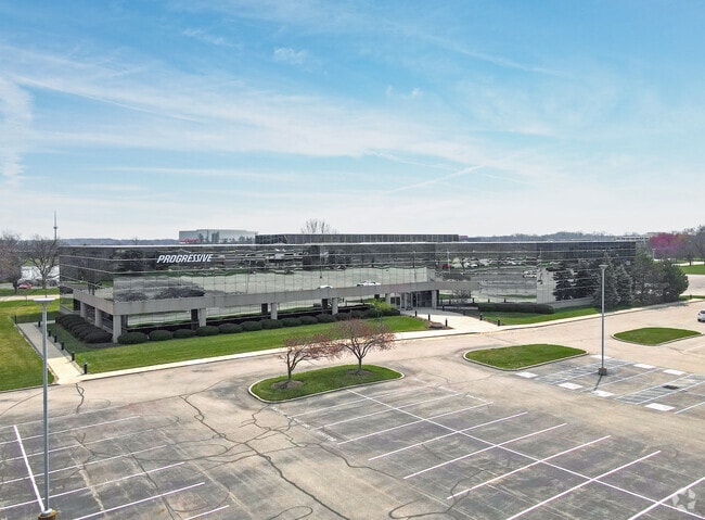
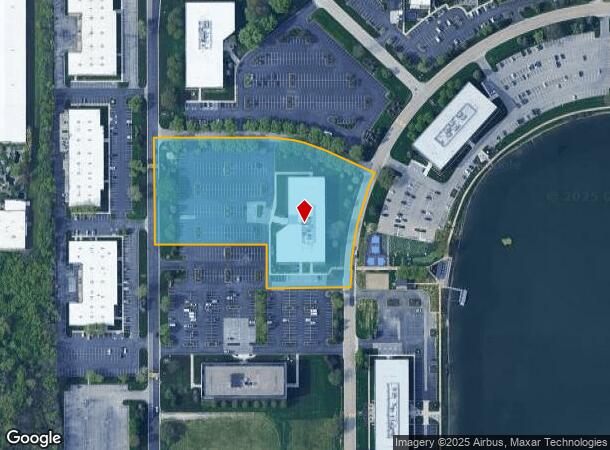
Property Record
9339 Priority Way West Dr, Indianapolis, IN 46240

Current Lease Availabilities
NEARBY LISTINGS FOR SALE OR LEASE
Property Detail
9339 Priority Way West Dr
49-02-17-114-002.000-800
PT W1/2 NW1/4 S17 T17 R4 BEG 310E & 964.58S OF NW COR; E327.13 SERLY 190 SE165.42 SWRLY 348.53 S6.05 W254.33 N112.91 W335.65 N419 TO BEG 5.172 AC.
Officebuilding
Marion
X
Indiana
18097C0061F
5.17 AC
2024
Keystone Crossing
2024
Indianapolis
320205
Indianapolis-Carmel-Anderson, IN
60,824 SF
DEMOGRAPHICS near 9339 Priority Way West Dr
1 Mile
3 Mile
5 Mile
2024 Total Population
5,124
57,506
176,922
2029 Population
5,298
59,934
185,045
Pop Growth 2024-2029
+ 3.40%
+ 4.22%
+ 4.59%
Average Age
37
41
41
2024 Total Households
2,749
26,915
80,202
HH Growth 2024-2029
+ 2.29%
+ 3.59%
+ 4.19%
Median Household Inc
$59,322
$76,148
$82,399
Avg Household Size
1.80
2.10
2.10
2024 Avg HH Vehicles
2.00
2.00
2.00
Median Home Value
$340,418
$302,681
$296,182
Median Year Built
1989
1981
1982
Nearby Places
- Restaurants
- Banks
- Shops
- Fitness
- Groceries
PUBLIC TRANSPORTATION
AIRPORT
Indianapolis International
DRIVE
WALK
Distance
Indianapolis International
39 min
30.7 mi
Freight Ports
Virginia Port Authority - Richmond
DRIVE
WALK
Distance
Virginia Port Authority - Richmond
1 min
498.1 mi
Nearby Properties
Address
Land Use
TOTAL SIZE
Lot Size
Zoning
Address
Land Use
TOTAL SIZE
Lot Size
Zoning
21,742 SF
39.35 AC
ZO01
Address
Land Use
TOTAL SIZE
Lot Size
Zoning
8,551 SF
45.92 AC
ZO01
Address
Land Use
TOTAL SIZE
Lot Size
Zoning
16,704 SF
109.83 AC
ZO01
Address
Land Use
TOTAL SIZE
Lot Size
Zoning
4,146 SF
45.91 AC
ZO01
Address
Land Use
TOTAL SIZE
Lot Size
Zoning
328,241 SF
91.83 AC
Address
Land Use
TOTAL SIZE
Lot Size
Zoning
315,968 SF
0.06 AC
ZO01
Address
Land Use
TOTAL SIZE
Lot Size
Zoning
408,298 SF
15.67 AC
Address
Land Use
TOTAL SIZE
Lot Size
Zoning
317,335 SF
4.22 AC
Address
Land Use
TOTAL SIZE
Lot Size
Zoning
117,212 SF
2.81 AC
Address
Land Use
TOTAL SIZE
Lot Size
Zoning
3,053 SF
10.33 AC
ZO01
Address
Land Use
TOTAL SIZE
Lot Size
Zoning
428,056 SF
20.27 AC
Address
Land Use
TOTAL SIZE
Lot Size
Zoning
345 SF
6.39 AC
ZO01
Address
Land Use
TOTAL SIZE
Lot Size
Zoning
5,314 SF
13.92 AC
ZO01
Address
Land Use
TOTAL SIZE
Lot Size
Zoning
107,078 SF
15.66 AC
ZO01
Address
Land Use
TOTAL SIZE
Lot Size
Zoning
290,488 SF
13.72 AC
Address
Land Use
TOTAL SIZE
Lot Size
Zoning
8,157 SF
113.93 AC
ZO01
Address
Land Use
TOTAL SIZE
Lot Size
Zoning
6,252 SF
52.04 AC
ZO01
Address
Land Use
TOTAL SIZE
Lot Size
Zoning
288 SF
7.35 AC
ZO01
Address
Land Use
TOTAL SIZE
Lot Size
Zoning
158,839 SF
0.06 AC
Address
Land Use
TOTAL SIZE
Lot Size
Zoning
1,904 SF
67.93 AC
ZO01
Address
Land Use
TOTAL SIZE
Lot Size
Zoning
6,229 SF
36.20 AC
ZO01
Address
Land Use
TOTAL SIZE
Lot Size
Zoning
3,316 SF
8.91 AC
ZO01
Address
Land Use
TOTAL SIZE
Lot Size
Zoning
229,554 SF
11.78 AC
ZO01
Address
Land Use
TOTAL SIZE
Lot Size
Zoning
235,807 SF
12.92 AC
Address
Land Use
TOTAL SIZE
Lot Size
Zoning
285,284 SF
7.78 AC
Address
Land Use
TOTAL SIZE
Lot Size
Zoning
10,514 SF
15.75 AC
ZO01
Address
Land Use
TOTAL SIZE
Lot Size
Zoning
1,700 SF
33.14 AC
ZO01
Address
Land Use
TOTAL SIZE
Lot Size
Zoning
5,149 SF
10.56 AC
ZO01
Address
Land Use
TOTAL SIZE
Lot Size
Zoning
127,922 SF
3.35 AC
ZO01
Address
Land Use
TOTAL SIZE
Lot Size
Zoning
182,869 SF
7 AC
ZO01
The World's #1 Commercial Real Estate Marketplace
Connect with us
© 2025 CoStar Group
The information above has been obtained from sources believed reliable. While we do not doubt its accuracy we have not verified it and make no guarantee, warranty or representation about it. It is your responsibility to independently confirm its accuracy and completeness. Any projections, opinions, assumptions, or estimates used are for example only and do not represent the current or future performance of the property. The value of this transaction to you depends on tax and other factors which should be evaluated by your tax, financial, and legal advisors. You and your advisors should conduct a careful, independent investigation of the property to determine to your satisfaction the suitability of the property for your needs.