Property Record
934 36Th St Se, Grand Rapids, MI 49508


NEARBY LISTINGS FOR SALE OR LEASE
Property Detail
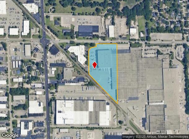
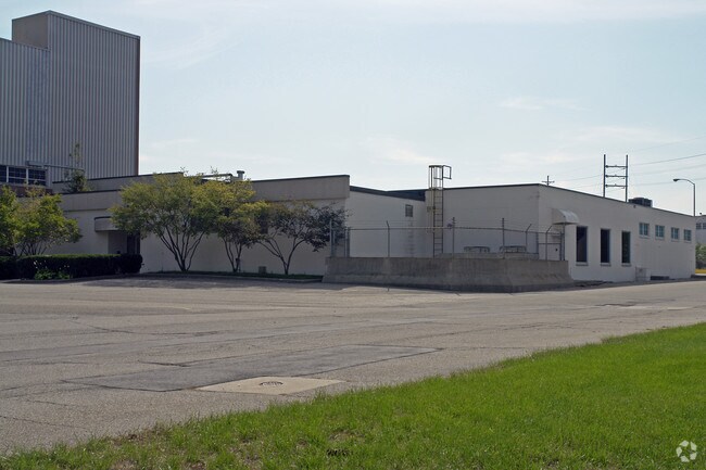
934 36Th St Se
41-18-20-101-016
411820101016 THAT PART NW 1/4 NW 1/4 LYING NELY OF NELY LINE OF PENNSYLVANIA RR R/W /50 FT WIDE/ EX THAT PART COM 241.16 FT S
Warehouse
Kent
X
Michigan
26081C0419D
9.44 AC
2024
S Grand Rapids/Kentwood
2025
West Michigan
012800
Grand Rapids-Wyoming, MI
104,023 SF
DEMOGRAPHICS near 934 36Th St Se
1 Mile
3 Mile
5 Mile
2024 Total Population
7,656
116,948
273,918
2029 Population
7,684
117,685
275,597
Pop Growth 2024-2029
+ 0.37%
+ 0.63%
+ 0.61%
Average Age
37
37
37
2024 Total Households
2,844
44,261
104,694
HH Growth 2024-2029
+ 0.35%
+ 0.67%
+ 0.67%
Median Household Inc
$49,699
$59,473
$62,877
Avg Household Size
2.60
2.60
2.50
2024 Avg HH Vehicles
2.00
2.00
2.00
Median Home Value
$160,272
$181,982
$207,994
Median Year Built
1967
1965
1969
Nearby Places
Map Layers
Map Styles
 Street
 Aerial
- Restaurants
- Banks
- Shops
- Fitness
- Groceries
PUBLIC TRANSPORTATION
COMMUTER RAIL
Grand Rapids Vernon J. Ehlers Station (Pere Marquette - Amtrak)
DRIVE
WALK
Distance
Grand Rapids Vernon J. Ehlers Station (Pere Marquette - Amtrak)
12 min
6.6 mi
AIRPORT
Gerald R Ford International
DRIVE
WALK
Distance
Gerald R Ford International
19 min
8.8 mi
Freight Ports
Port Milwaukee
DRIVE
WALK
Distance
Port Milwaukee
309 min
261.6 mi
Nearby Properties
Address
Land Use
TOTAL SIZE
Lot Size
Zoning
Address
Land Use
TOTAL SIZE
Lot Size
Zoning
385,631 SF
45.27 AC
R-PUD-1
Address
Land Use
TOTAL SIZE
Lot Size
Zoning
446,986 SF
72.57 AC
R4
Address
Land Use
TOTAL SIZE
Lot Size
Zoning
649,177 SF
55.67 AC
SD-IT
Address
Land Use
TOTAL SIZE
Lot Size
Zoning
223,931 SF
18 AC
R-PUD-1
Address
Land Use
TOTAL SIZE
Lot Size
Zoning
941,968 SF
38.56 AC
SD-IT
Address
Land Use
TOTAL SIZE
Lot Size
Zoning
194,153 SF
15.84 AC
MCN-C
Address
Land Use
TOTAL SIZE
Lot Size
Zoning
216,171 SF
32.06 AC
R4
Address
Land Use
TOTAL SIZE
Lot Size
Zoning
27.25 AC
SD-PRD
Address
Land Use
TOTAL SIZE
Lot Size
Zoning
1,426,319 SF
54.81 AC
SD-IT
Address
Land Use
TOTAL SIZE
Lot Size
Zoning
264,739 SF
26.56 AC
I2
Address
Land Use
TOTAL SIZE
Lot Size
Zoning
13.71 AC
MCN-LDR
Address
Land Use
TOTAL SIZE
Lot Size
Zoning
146,732 SF
21.16 AC
R4
Address
Land Use
TOTAL SIZE
Lot Size
Zoning
153,571 SF
12.28 AC
SD-PRD
Address
Land Use
TOTAL SIZE
Lot Size
Zoning
258,128 SF
20.41 AC
R4
Address
Land Use
TOTAL SIZE
Lot Size
Zoning
536,296 SF
26.16 AC
SD-IT
Address
Land Use
TOTAL SIZE
Lot Size
Zoning
179,436 SF
24.94 AC
I2
Address
Land Use
TOTAL SIZE
Lot Size
Zoning
348,367 SF
12.15 AC
SD-IT
Address
Land Use
TOTAL SIZE
Lot Size
Zoning
295,250 SF
Address
Land Use
TOTAL SIZE
Lot Size
Zoning
225,906 SF
14.40 AC
R4
Address
Land Use
TOTAL SIZE
Lot Size
Zoning
63,000 SF
15.28 AC
C3
Address
Land Use
TOTAL SIZE
Lot Size
Zoning
136,112 SF
17.63 AC
MON-C
Address
Land Use
TOTAL SIZE
Lot Size
Zoning
13.86 AC
Address
Land Use
TOTAL SIZE
Lot Size
Zoning
165,085 SF
22.58 AC
R4
Address
Land Use
TOTAL SIZE
Lot Size
Zoning
Address
Land Use
TOTAL SIZE
Lot Size
Zoning
158,240 SF
13.56 AC
R4
Address
Land Use
TOTAL SIZE
Lot Size
Zoning
349,885 SF
8.92 AC
I1
Address
Land Use
TOTAL SIZE
Lot Size
Zoning
123,517 SF
15.71 AC
MON-C
Address
Land Use
TOTAL SIZE
Lot Size
Zoning
157,386 SF
13.11 AC
R4
Address
Land Use
TOTAL SIZE
Lot Size
Zoning
442,193 SF
17.90 AC
I1
Address
Land Use
TOTAL SIZE
Lot Size
Zoning
256,575 SF
16.21 AC
I2
The World's #1 Commercial Real Estate Marketplace
Connect with us
© 2025 CoStar Group
The information above has been obtained from sources believed reliable. While we do not doubt its accuracy we have not verified it and make no guarantee, warranty or representation about it. It is your responsibility to independently confirm its accuracy and completeness. Any projections, opinions, assumptions, or estimates used are for example only and do not represent the current or future performance of the property. The value of this transaction to you depends on tax and other factors which should be evaluated by your tax, financial, and legal advisors. You and your advisors should conduct a careful, independent investigation of the property to determine to your satisfaction the suitability of the property for your needs.