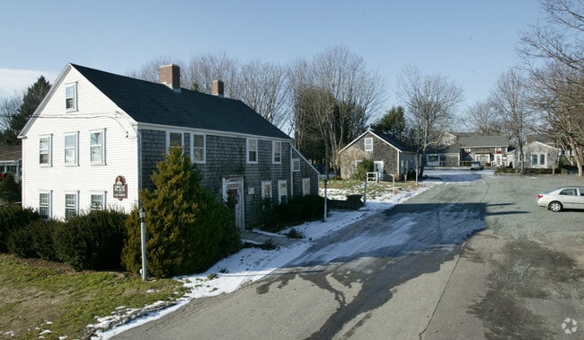
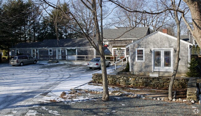
Property Record
934 E Main Rd, Portsmouth, RI 02871

Property Detail
934 E Main Rd
PORT-000057-000000-000003
Newport
Commercialofficeresidentialmixeduse
Rhode Island
C
0.98 AC
B and X Area of moderate flood hazard, usually the area between the limits of the 100-year and 500-year floods.
Newport County
2025
Providence
2025
Providence-Warwick, RI-MA
040104
NEARBY LISTINGS FOR SALE OR LEASE
-
-
View all Portsmouth listings for sale on LoopNet.com
DEMOGRAPHICS near 934 E Main Rd
1 mile
3 mile
5 mile
2025 Total Population
1,671
13,737
42,764
2030 Population
1,592
13,077
42,161
Pop Growth 2025-2030
(4.73%)
(4.80%)
(1.41%)
Average Age
47
46
44
2025 Total Households
647
5,422
17,500
HH Growth 2025-2030
(3.86%)
(3.97%)
(2.45%)
Median Household Inc
$146,982
$129,093
$104,936
Avg Household Size
2.50
2.50
2.30
2025 Avg HH Vehicles
2.00
2.00
2.00
Median Home Value
$759,771
$735,499
$659,157
Median Year Built
1972
1974
1973
Nearby Places
Map Layers
Map Styles
 Street
 Aerial
Layers
 Traffic
 Biking
Places
Listings with unknown addresses are not visible on the map
- Restaurants
- Banks
- Shops
- Fitness
- Groceries
PUBLIC TRANSPORTATION
AIRPORT
Rhode Island Tf Green International
Drive
Walk
Distance
Rhode Island Tf Green International
54 min
33.3 mi
Freight Ports
Port of Davisville, RI
Drive
Walk
Distance
Port of Davisville, RI
40 min
22.1 mi
Nearby Properties
Address
Land Use
TOTAL SIZE
Lot Size
Zoning
Address
Land Use
TOTAL SIZE
Lot Size
Zoning
104.20 AC
P
Address
Land Use
TOTAL SIZE
Lot Size
Zoning
13,478 SF
1 AC
HI
Address
Land Use
TOTAL SIZE
Lot Size
Zoning
24.70 AC
RMA
Address
Land Use
TOTAL SIZE
Lot Size
Zoning
120.20 AC
HI
Address
Land Use
TOTAL SIZE
Lot Size
Zoning
157,806 SF
36.80 AC
R30
Address
Land Use
TOTAL SIZE
Lot Size
Zoning
17.92 AC
RMA
Address
Land Use
TOTAL SIZE
Lot Size
Zoning
26.66 AC
R20
Address
Land Use
TOTAL SIZE
Lot Size
Zoning
99,369 SF
15.88 AC
GBA
Address
Land Use
TOTAL SIZE
Lot Size
Zoning
9.01 AC
R20
Address
Land Use
TOTAL SIZE
Lot Size
Zoning
23.78 AC
WD
Address
Land Use
TOTAL SIZE
Lot Size
Zoning
16 AC
WD
Address
Land Use
TOTAL SIZE
Lot Size
Zoning
38 AC
OS
Address
Land Use
TOTAL SIZE
Lot Size
Zoning
75,818 SF
7.51 AC
GBA
Address
Land Use
TOTAL SIZE
Lot Size
Zoning
6 AC
HI
Address
Land Use
TOTAL SIZE
Lot Size
Zoning
74,293 SF
10.77 AC
TC
Address
Land Use
TOTAL SIZE
Lot Size
Zoning
367.97 AC
OS
Address
Land Use
TOTAL SIZE
Lot Size
Zoning
4.38 AC
GB
Address
Land Use
TOTAL SIZE
Lot Size
Zoning
56.41 AC
R40
Address
Land Use
TOTAL SIZE
Lot Size
Zoning
44,815 SF
5 AC
R20
Address
Land Use
TOTAL SIZE
Lot Size
Zoning
40,664 SF
4.51 AC
P
Address
Land Use
TOTAL SIZE
Lot Size
Zoning
44.80 AC
R20
Address
Land Use
TOTAL SIZE
Lot Size
Zoning
33,128 SF
3.40 AC
GBA
Address
Land Use
TOTAL SIZE
Lot Size
Zoning
39,116 SF
1 AC
R30
Address
Land Use
TOTAL SIZE
Lot Size
Zoning
123 AC
OS
Address
Land Use
TOTAL SIZE
Lot Size
Zoning
222.84 AC
L1
Address
Land Use
TOTAL SIZE
Lot Size
Zoning
1 AC
R60
Address
Land Use
TOTAL SIZE
Lot Size
Zoning
44 AC
R60
Address
Land Use
TOTAL SIZE
Lot Size
Zoning
8.10 AC
P
Address
Land Use
TOTAL SIZE
Lot Size
Zoning
60,480 SF
3.88 AC
R20
Address
Land Use
TOTAL SIZE
Lot Size
Zoning
4 AC
R30
The World's #1 Commercial Real Estate Marketplace
Connect with us
© 2026 CoStar Group
The information above has been obtained from sources believed reliable. While we do not doubt its accuracy we have not verified it and make no guarantee, warranty or representation about it. It is your responsibility to independently confirm its accuracy and completeness. Any projections, opinions, assumptions, or estimates used are for example only and do not represent the current or future performance of the property. The value of this transaction to you depends on tax and other factors which should be evaluated by your tax, financial, and legal advisors. You and your advisors should conduct a careful, independent investigation of the property to determine to your satisfaction the suitability of the property for your needs.