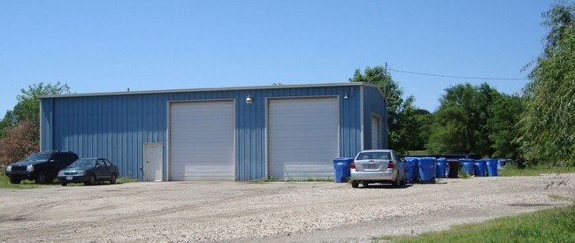
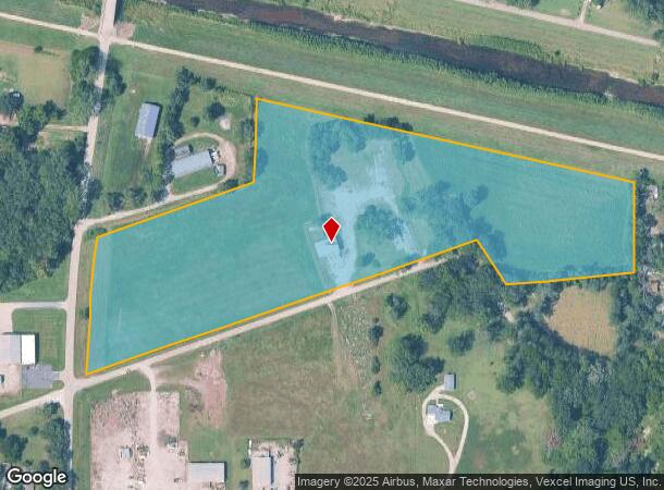
Property Record
934 Ne Calhoun Bluff Ln, Topeka, KS 66617
NEARBY LISTINGS FOR SALE OR LEASE
Property Detail
934 Ne Calhoun Bluff Ln
Topeka, KS
Kirkham Sub No 2
105-16-0-30-01-001-000
KIRKHAM SUB NO 2, S16, T11, R16, BLOCK A, LOT 1+, ACRES 13.24, BLK A LOTS 1-2-3-4-5-6-7 KIRKHAM SUB #2 SECTION 16 TOWNSHIP 11 RANGE 16
Shipyard
Shawnee
X
Kansas
20177C0209E
1
2024
13.24 AC
2025
Topeka
000800
Kansas City
2,400 SF
DEMOGRAPHICS near 934 Ne Calhoun Bluff Ln
1 Mile
3 Mile
5 Mile
2024 Total Population
846
17,666
61,381
2029 Population
839
17,562
61,319
Pop Growth 2024-2029
(0.83%)
(0.59%)
(0.10%)
Average Age
42
41
39
2024 Total Households
338
7,260
24,731
HH Growth 2024-2029
(0.59%)
(0.66%)
(0.04%)
Median Household Inc
$52,963
$49,164
$46,380
Avg Household Size
2.50
2.30
2.30
2024 Avg HH Vehicles
2.00
2.00
2.00
Median Home Value
$159,374
$103,426
$100,341
Median Year Built
1976
1957
1958
Nearby Places
Map Layers
Map Styles
 Street
 Aerial
- Restaurants
- Banks
- Shops
- Fitness
- Groceries
PUBLIC TRANSPORTATION
COMMUTER RAIL
Topeka Amtrak Station (Southwest Chief - Amtrak)
DRIVE
WALK
Distance
Topeka Amtrak Station (Southwest Chief - Amtrak)
9 min
4.4 mi
Freight Ports
Tulsa Port Of Catoosa
DRIVE
WALK
Distance
Tulsa Port Of Catoosa
282 min
238.2 mi
Nearby Properties
Address
Land Use
TOTAL SIZE
Lot Size
Zoning
Address
Land Use
TOTAL SIZE
Lot Size
Zoning
181,781 SF
569.17 AC
R1
Address
Land Use
TOTAL SIZE
Lot Size
Zoning
129,425 SF
96.26 AC
R1
Address
Land Use
TOTAL SIZE
Lot Size
Zoning
92,118 SF
10.87 AC
R2
Address
Land Use
TOTAL SIZE
Lot Size
Zoning
238,319 SF
170.40 AC
PUD,RR1,OI
Address
Land Use
TOTAL SIZE
Lot Size
Zoning
26,269 SF
8.18 AC
RR1
Address
Land Use
TOTAL SIZE
Lot Size
Zoning
18,984 SF
0.35 AC
HL,X3
Address
Land Use
TOTAL SIZE
Lot Size
Zoning
27,718 SF
24.23 AC
RR1
Address
Land Use
TOTAL SIZE
Lot Size
Zoning
35,055 SF
109.89 AC
RR1
Address
Land Use
TOTAL SIZE
Lot Size
Zoning
96,600 SF
23.56 AC
R1
Address
Land Use
TOTAL SIZE
Lot Size
Zoning
28,978 SF
2.90 AC
PUD,M3
Address
Land Use
TOTAL SIZE
Lot Size
Zoning
72,295 SF
13.39 AC
R1
Address
Land Use
TOTAL SIZE
Lot Size
Zoning
2,595,744 SF
197.79 AC
I2
Address
Land Use
TOTAL SIZE
Lot Size
Zoning
24,462 SF
40.76 AC
OS1
Address
Land Use
TOTAL SIZE
Lot Size
Zoning
12,464 SF
0.35 AC
I2
Address
Land Use
TOTAL SIZE
Lot Size
Zoning
35,320 SF
2.90 AC
R2
Address
Land Use
TOTAL SIZE
Lot Size
Zoning
88,238 SF
32.42 AC
R1,R2
Address
Land Use
TOTAL SIZE
Lot Size
Zoning
18,768 SF
14.94 AC
PUD,M2
Address
Land Use
TOTAL SIZE
Lot Size
Zoning
194,614 SF
23.42 AC
PUD,C4,R1
Address
Land Use
TOTAL SIZE
Lot Size
Zoning
49,341 SF
4.86 AC
D3
Address
Land Use
TOTAL SIZE
Lot Size
Zoning
21,188 SF
0.76 AC
R2
Address
Land Use
TOTAL SIZE
Lot Size
Zoning
16,860 SF
2.65 AC
C4
Address
Land Use
TOTAL SIZE
Lot Size
Zoning
18,595 SF
9.19 AC
RR1
Address
Land Use
TOTAL SIZE
Lot Size
Zoning
220,817 SF
15.72 AC
I2
Address
Land Use
TOTAL SIZE
Lot Size
Zoning
20,504 SF
1.51 AC
R2,X1
Address
Land Use
TOTAL SIZE
Lot Size
Zoning
42,300 SF
8.66 AC
D3
Address
Land Use
TOTAL SIZE
Lot Size
Zoning
17,654 SF
0.62 AC
X3
Address
Land Use
TOTAL SIZE
Lot Size
Zoning
15,267 SF
1.30 AC
PUD,M2
Address
Land Use
TOTAL SIZE
Lot Size
Zoning
11,900 SF
0.29 AC
X3
Address
Land Use
TOTAL SIZE
Lot Size
Zoning
38,146 SF
0.98 AC
I1
Address
Land Use
TOTAL SIZE
Lot Size
Zoning
33,414 SF
2.90 AC
R2
The World's #1 Commercial Real Estate Marketplace
Connect with us
© 2025 CoStar Group
The information above has been obtained from sources believed reliable. While we do not doubt its accuracy we have not verified it and make no guarantee, warranty or representation about it. It is your responsibility to independently confirm its accuracy and completeness. Any projections, opinions, assumptions, or estimates used are for example only and do not represent the current or future performance of the property. The value of this transaction to you depends on tax and other factors which should be evaluated by your tax, financial, and legal advisors. You and your advisors should conduct a careful, independent investigation of the property to determine to your satisfaction the suitability of the property for your needs.