Property Record
9340 Coal Hill Rd, Taberg, NY 13471
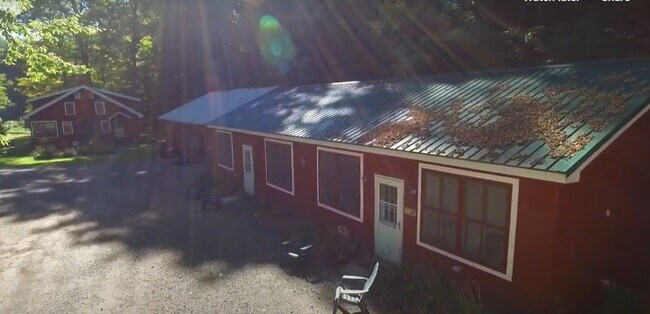
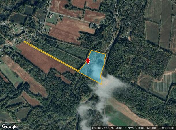
This Property Is For Sale
NEARBY LISTINGS FOR SALE OR LEASE
-
-
View all Taberg listings for sale on LoopNet.com
Property Detail
9340 Coal Hill Rd
Utica-Rome, NY
Oneida
302000 168.000-2-9
New York
Sfr
20.66 AC
AE
Outlying Oneida County
36065C0336F
Utica/Rome
1,092 SF
DEMOGRAPHICS near 9340 Coal Hill Rd
1 Mile
3 Mile
5 Mile
2024 Total Population
355
2,614
6,232
2029 Population
348
2,589
6,184
Pop Growth 2024-2029
(1.97%)
(0.96%)
(0.77%)
Average Age
41
42
42
2024 Total Households
144
1,028
2,436
HH Growth 2024-2029
(2.08%)
(1.07%)
(0.90%)
Median Household Inc
$55,937
$57,671
$64,150
Avg Household Size
2.50
2.50
2.50
2024 Avg HH Vehicles
2.00
2.00
2.00
Median Home Value
$113,333
$124,733
$132,937
Median Year Built
1981
1981
1978
Nearby Places
Map Layers
Map Styles
 Street
 Aerial
- Restaurants
- Banks
- Shops
- Fitness
- Groceries
PUBLIC TRANSPORTATION
AIRPORT
Syracuse Hancock International
DRIVE
WALK
Distance
Syracuse Hancock International
66 min
39.6 mi
Freight Ports
Albany, NY Port
DRIVE
WALK
Distance
Albany, NY Port
154 min
120.9 mi
Nearby Properties
Address
Land Use
TOTAL SIZE
Lot Size
Zoning
Address
Land Use
TOTAL SIZE
Lot Size
Zoning
29.82 AC
01 - NOT Z
Address
Land Use
TOTAL SIZE
Lot Size
Zoning
1,152 SF
35 AC
01 - NOT Z
Address
Land Use
TOTAL SIZE
Lot Size
Zoning
Address
Land Use
TOTAL SIZE
Lot Size
Zoning
2.03 AC
01 - NOT Z
Address
Land Use
TOTAL SIZE
Lot Size
Zoning
8.31 AC
01 - NOT Z
Address
Land Use
TOTAL SIZE
Lot Size
Zoning
717 SF
21.37 AC
01 - NOT Z
Address
Land Use
TOTAL SIZE
Lot Size
Zoning
29.20 AC
01 - NOT Z
Address
Land Use
TOTAL SIZE
Lot Size
Zoning
5.80 AC
01 - NOT Z
Address
Land Use
TOTAL SIZE
Lot Size
Zoning
1.85 AC
01 - NOT Z
Address
Land Use
TOTAL SIZE
Lot Size
Zoning
11.60 AC
Address
Land Use
TOTAL SIZE
Lot Size
Zoning
26.50 AC
Address
Land Use
TOTAL SIZE
Lot Size
Zoning
01 - NOT Z
Address
Land Use
TOTAL SIZE
Lot Size
Zoning
780 SF
1.53 AC
01 - NOT Z
Address
Land Use
TOTAL SIZE
Lot Size
Zoning
350 SF
8.60 AC
01 - NOT Z
Address
Land Use
TOTAL SIZE
Lot Size
Zoning
0.37 AC
01 - NOT Z
Address
Land Use
TOTAL SIZE
Lot Size
Zoning
4.93 AC
01 - NOT Z
Address
Land Use
TOTAL SIZE
Lot Size
Zoning
138 AC
01 - NOT Z
Address
Land Use
TOTAL SIZE
Lot Size
Zoning
286 SF
01 - NOT Z
Address
Land Use
TOTAL SIZE
Lot Size
Zoning
327 SF
0.65 AC
01 - NOT Z
Address
Land Use
TOTAL SIZE
Lot Size
Zoning
216 SF
2.80 AC
01 - NOT Z
Address
Land Use
TOTAL SIZE
Lot Size
Zoning
528 SF
63.40 AC
01 - NOT Z
Address
Land Use
TOTAL SIZE
Lot Size
Zoning
676 SF
0.98 AC
01 - NOT Z
Address
Land Use
TOTAL SIZE
Lot Size
Zoning
208 SF
5.30 AC
01 - NOT Z
Address
Land Use
TOTAL SIZE
Lot Size
Zoning
5 AC
01 - NOT Z
Address
Land Use
TOTAL SIZE
Lot Size
Zoning
0.64 AC
01 - NOT Z
Address
Land Use
TOTAL SIZE
Lot Size
Zoning
149.50 AC
01 - NOT Z
Address
Land Use
TOTAL SIZE
Lot Size
Zoning
2 AC
01 - NOT Z
Address
Land Use
TOTAL SIZE
Lot Size
Zoning
850 SF
9.30 AC
01 - NOT Z
Address
Land Use
TOTAL SIZE
Lot Size
Zoning
0.01 AC
Address
Land Use
TOTAL SIZE
Lot Size
Zoning
118 AC
01 - NOT Z
The World's #1 Commercial Real Estate Marketplace
Connect with us
© 2025 CoStar Group
The information above has been obtained from sources believed reliable. While we do not doubt its accuracy we have not verified it and make no guarantee, warranty or representation about it. It is your responsibility to independently confirm its accuracy and completeness. Any projections, opinions, assumptions, or estimates used are for example only and do not represent the current or future performance of the property. The value of this transaction to you depends on tax and other factors which should be evaluated by your tax, financial, and legal advisors. You and your advisors should conduct a careful, independent investigation of the property to determine to your satisfaction the suitability of the property for your needs.