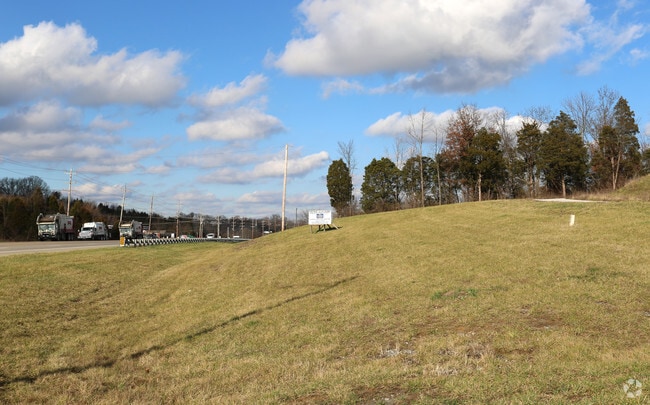
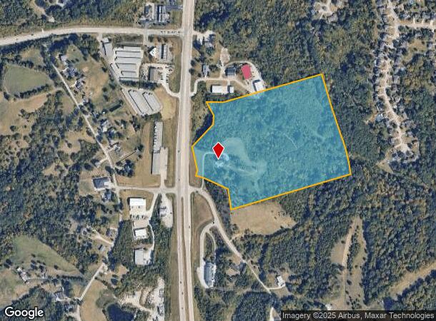
Property Record
9349 Alexandria Pike, Alexandria, KY 41001
NEARBY LISTINGS FOR SALE OR LEASE
Property Detail
9349 Alexandria Pike
999-99-22-790.00
Blue Grass Subdivision
Agriculturalland
22.505 ACRES
X
Campbell
21037C0092E
Kentucky
2024
22.51 AC
2025
Outlying N Kentucky
051904
Cincinnati/Dayton
1,579 SF
Cincinnati, OH-KY-IN
DEMOGRAPHICS near 9349 Alexandria Pike
1 Mile
3 Mile
5 Mile
2024 Total Population
2,568
15,346
22,465
2029 Population
2,576
15,503
22,679
Pop Growth 2024-2029
+ 0.31%
+ 1.02%
+ 0.95%
Average Age
39
40
41
2024 Total Households
874
5,561
8,229
HH Growth 2024-2029
+ 0.11%
+ 1.02%
+ 0.95%
Median Household Inc
$95,113
$97,260
$94,275
Avg Household Size
2.90
2.70
2.70
2024 Avg HH Vehicles
2.00
2.00
2.00
Median Home Value
$241,472
$247,064
$253,841
Median Year Built
1995
1991
1990
Nearby Places
Map Layers
Map Styles
 Street
 Aerial
- Restaurants
- Banks
- Shops
- Fitness
- Groceries
PUBLIC TRANSPORTATION
AIRPORT
Cincinnati/Northern Kentucky International
DRIVE
WALK
Distance
Cincinnati/Northern Kentucky International
39 min
21.6 mi
Freight Ports
Port of Toledo
DRIVE
WALK
Distance
Port of Toledo
266 min
218.9 mi
Nearby Properties
Address
Land Use
TOTAL SIZE
Lot Size
Zoning
Address
Land Use
TOTAL SIZE
Lot Size
Zoning
336,060 SF
61.32 AC
Address
Land Use
TOTAL SIZE
Lot Size
Zoning
54.90 AC
Address
Land Use
TOTAL SIZE
Lot Size
Zoning
137,878 SF
14.55 AC
Address
Land Use
TOTAL SIZE
Lot Size
Zoning
217,080 SF
45.14 AC
Address
Land Use
TOTAL SIZE
Lot Size
Zoning
1,500 SF
21.25 AC
Address
Land Use
TOTAL SIZE
Lot Size
Zoning
79,696 SF
18.96 AC
Address
Land Use
TOTAL SIZE
Lot Size
Zoning
5,142 SF
55.57 AC
Address
Land Use
TOTAL SIZE
Lot Size
Zoning
82,000 SF
4.60 AC
Address
Land Use
TOTAL SIZE
Lot Size
Zoning
4,331 SF
7.27 AC
Address
Land Use
TOTAL SIZE
Lot Size
Zoning
Address
Land Use
TOTAL SIZE
Lot Size
Zoning
44,788 SF
9.42 AC
Address
Land Use
TOTAL SIZE
Lot Size
Zoning
12,148 SF
0.43 AC
Address
Land Use
TOTAL SIZE
Lot Size
Zoning
40.01 AC
Address
Land Use
TOTAL SIZE
Lot Size
Zoning
39,434 SF
5.46 AC
Address
Land Use
TOTAL SIZE
Lot Size
Zoning
Address
Land Use
TOTAL SIZE
Lot Size
Zoning
844 SF
25.46 AC
Address
Land Use
TOTAL SIZE
Lot Size
Zoning
5,200 SF
2.20 AC
Address
Land Use
TOTAL SIZE
Lot Size
Zoning
9,100 SF
2.03 AC
Address
Land Use
TOTAL SIZE
Lot Size
Zoning
676 SF
84.05 AC
Address
Land Use
TOTAL SIZE
Lot Size
Zoning
10,098 SF
2.36 AC
Address
Land Use
TOTAL SIZE
Lot Size
Zoning
6,000 SF
1.07 AC
Address
Land Use
TOTAL SIZE
Lot Size
Zoning
49,248 SF
3.10 AC
Address
Land Use
TOTAL SIZE
Lot Size
Zoning
16,332 SF
1.56 AC
Address
Land Use
TOTAL SIZE
Lot Size
Zoning
4,550 SF
21.31 AC
Address
Land Use
TOTAL SIZE
Lot Size
Zoning
1,568 SF
0.69 AC
Address
Land Use
TOTAL SIZE
Lot Size
Zoning
7,396 SF
1.26 AC
Address
Land Use
TOTAL SIZE
Lot Size
Zoning
9,100 SF
1.91 AC
Address
Land Use
TOTAL SIZE
Lot Size
Zoning
2,144 SF
0.70 AC
Address
Land Use
TOTAL SIZE
Lot Size
Zoning
18,648 SF
3.97 AC
Address
Land Use
TOTAL SIZE
Lot Size
Zoning
5,040 SF
3.86 AC
The World's #1 Commercial Real Estate Marketplace
Connect with us
© 2025 CoStar Group
The information above has been obtained from sources believed reliable. While we do not doubt its accuracy we have not verified it and make no guarantee, warranty or representation about it. It is your responsibility to independently confirm its accuracy and completeness. Any projections, opinions, assumptions, or estimates used are for example only and do not represent the current or future performance of the property. The value of this transaction to you depends on tax and other factors which should be evaluated by your tax, financial, and legal advisors. You and your advisors should conduct a careful, independent investigation of the property to determine to your satisfaction the suitability of the property for your needs.