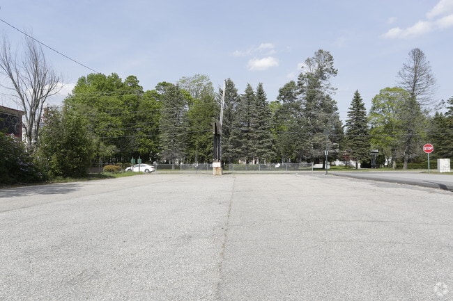
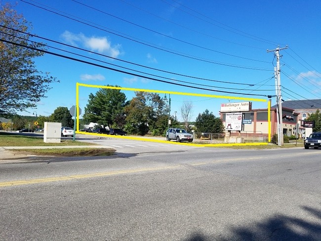
Property Record
935 Main St, Sanford, ME 04073

NEARBY LISTINGS FOR SALE OR LEASE
-
-
View all Sanford listings for sale on LoopNet.com
Property Detail
935 Main St
Governmentalpublicusegeneral
York
X
Maine
23031C0392G
3 AC
0
York County
2025
Portland/South Portland
030203
Portland-South Portland, ME
16,708 SF
SANF-000001-K000030
DEMOGRAPHICS near 935 Main St
1 Mile
3 Mile
5 Mile
2024 Total Population
10,013
19,294
24,750
2029 Population
10,610
20,353
26,048
Pop Growth 2024-2029
+ 5.96%
+ 5.49%
+ 5.24%
Average Age
39
41
41
2024 Total Households
4,094
7,976
10,207
HH Growth 2024-2029
+ 5.89%
+ 5.42%
+ 5.16%
Median Household Inc
$62,315
$65,717
$67,439
Avg Household Size
2.30
2.30
2.30
2024 Avg HH Vehicles
2.00
2.00
2.00
Median Home Value
$213,625
$232,306
$241,989
Median Year Built
1962
1971
1974
Nearby Places
Map Layers
Map Styles
 Street
 Aerial
- Restaurants
- Banks
- Shops
- Fitness
- Groceries
PUBLIC TRANSPORTATION
AIRPORT
Portland International Jetport
DRIVE
WALK
Distance
Portland International Jetport
44 min
31.7 mi
Portsmouth International at Pease
DRIVE
WALK
Distance
Portsmouth International at Pease
54 min
35.0 mi
Freight Ports
Portland, ME
DRIVE
WALK
Distance
Portland, ME
45 min
34.3 mi
SALE & LEASE HISTORY
LISTING DATE
SALE/LEASE

Sep 25, 2017
For Sale
Nearby Properties
Address
Land Use
TOTAL SIZE
Lot Size
Zoning
Address
Land Use
TOTAL SIZE
Lot Size
Zoning
220,000 SF
137 AC
GR
Address
Land Use
TOTAL SIZE
Lot Size
Zoning
61,542 SF
11.50 AC
Address
Land Use
TOTAL SIZE
Lot Size
Zoning
30.33 AC
SB
Address
Land Use
TOTAL SIZE
Lot Size
Zoning
94,234 SF
17.65 AC
OR
Address
Land Use
TOTAL SIZE
Lot Size
Zoning
Address
Land Use
TOTAL SIZE
Lot Size
Zoning
9 AC
GR
Address
Land Use
TOTAL SIZE
Lot Size
Zoning
18.86 AC
SFR
Address
Land Use
TOTAL SIZE
Lot Size
Zoning
55,418 SF
1.54 AC
DB
Address
Land Use
TOTAL SIZE
Lot Size
Zoning
83,505 SF
17 AC
RD
Address
Land Use
TOTAL SIZE
Lot Size
Zoning
81.92 AC
SFR
Address
Land Use
TOTAL SIZE
Lot Size
Zoning
6.71 AC
SB
Address
Land Use
TOTAL SIZE
Lot Size
Zoning
61,457 SF
0.87 AC
IR
Address
Land Use
TOTAL SIZE
Lot Size
Zoning
Address
Land Use
TOTAL SIZE
Lot Size
Zoning
2.59 AC
Address
Land Use
TOTAL SIZE
Lot Size
Zoning
14,044 SF
2.62 AC
CC
Address
Land Use
TOTAL SIZE
Lot Size
Zoning
8.60 AC
ORBP
Address
Land Use
TOTAL SIZE
Lot Size
Zoning
2.65 AC
CC
Address
Land Use
TOTAL SIZE
Lot Size
Zoning
19,019 SF
19.41 AC
SFR
Address
Land Use
TOTAL SIZE
Lot Size
Zoning
92,944 SF
19.38 AC
SB
Address
Land Use
TOTAL SIZE
Lot Size
Zoning
71,566 SF
12 AC
UB
Address
Land Use
TOTAL SIZE
Lot Size
Zoning
1,080 SF
3.50 AC
GR
Address
Land Use
TOTAL SIZE
Lot Size
Zoning
78,259 SF
8.29 AC
SFR
Address
Land Use
TOTAL SIZE
Lot Size
Zoning
2.25 AC
GR
Address
Land Use
TOTAL SIZE
Lot Size
Zoning
4.72 AC
SFR
Address
Land Use
TOTAL SIZE
Lot Size
Zoning
26,748 SF
1.20 AC
Address
Land Use
TOTAL SIZE
Lot Size
Zoning
3.64 AC
UB
Address
Land Use
TOTAL SIZE
Lot Size
Zoning
Address
Land Use
TOTAL SIZE
Lot Size
Zoning
4 AC
GR
Address
Land Use
TOTAL SIZE
Lot Size
Zoning
2.33 AC
CC
The World's #1 Commercial Real Estate Marketplace
Connect with us
© 2025 CoStar Group
The information above has been obtained from sources believed reliable. While we do not doubt its accuracy we have not verified it and make no guarantee, warranty or representation about it. It is your responsibility to independently confirm its accuracy and completeness. Any projections, opinions, assumptions, or estimates used are for example only and do not represent the current or future performance of the property. The value of this transaction to you depends on tax and other factors which should be evaluated by your tax, financial, and legal advisors. You and your advisors should conduct a careful, independent investigation of the property to determine to your satisfaction the suitability of the property for your needs.