Property Record
935 State Route 130, Trafford, PA 15085
NEARBY LISTINGS FOR SALE OR LEASE
-
-
View all Trafford listings for sale on LoopNet.com
Property Detail
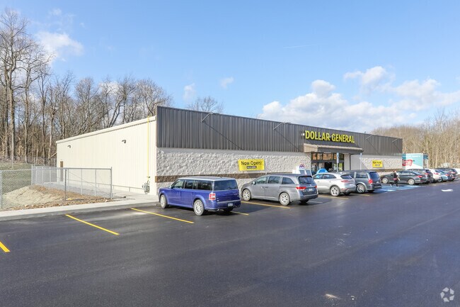
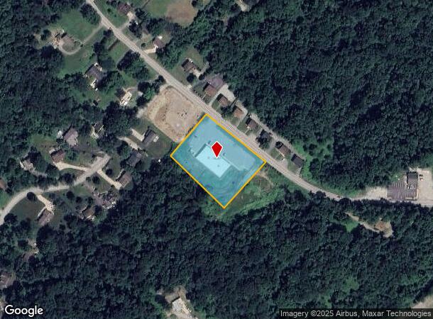
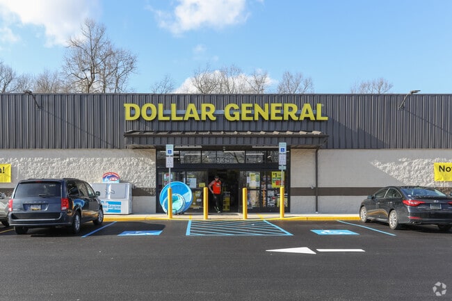
935 State Route 130
Pittsburgh, PA
Fabyonic Plan Of Lots
55-08-05-0-056
LOT 2, STORE FABYONIC PLAN
Commercialofficeresidentialmixeduse
Westmoreland
X
Pennsylvania
42129C0189F
2
2025
1.72 AC
2025
Westmoreland County
802301
Pittsburgh
DEMOGRAPHICS near 935 State Route 130
1 Mile
3 Mile
5 Mile
2024 Total Population
1,798
20,651
83,789
2029 Population
1,788
20,341
82,736
Pop Growth 2024-2029
(0.56%)
(1.50%)
(1.26%)
Average Age
45
45
44
2024 Total Households
702
8,206
35,544
HH Growth 2024-2029
(0.71%)
(1.58%)
(1.29%)
Median Household Inc
$87,583
$93,719
$80,532
Avg Household Size
2.50
2.50
2.30
2024 Avg HH Vehicles
2.00
2.00
2.00
Median Home Value
$238,965
$241,864
$217,887
Median Year Built
1966
1973
1969
Nearby Places
Map Layers
Map Styles
 Street
 Aerial
- Restaurants
- Banks
- Shops
- Fitness
- Groceries
PUBLIC TRANSPORTATION
AIRPORT
Arnold Palmer Regional
DRIVE
WALK
Distance
Arnold Palmer Regional
36 min
20.6 mi
Pittsburgh International
DRIVE
WALK
Distance
Pittsburgh International
56 min
36.2 mi
Freight Ports
Port of Baltimore
DRIVE
WALK
Distance
Port of Baltimore
273 min
229.8 mi
SALE & LEASE HISTORY
LISTING DATE
SALE/LEASE

Feb 18, 2020
For Sale
Nearby Properties
Address
Land Use
TOTAL SIZE
Lot Size
Zoning
Address
Land Use
TOTAL SIZE
Lot Size
Zoning
189.30 AC
Address
Land Use
TOTAL SIZE
Lot Size
Zoning
27.40 AC
Address
Land Use
TOTAL SIZE
Lot Size
Zoning
14.42 AC
Address
Land Use
TOTAL SIZE
Lot Size
Zoning
10.42 AC
Address
Land Use
TOTAL SIZE
Lot Size
Zoning
120,046 SF
20.93 AC
Address
Land Use
TOTAL SIZE
Lot Size
Zoning
1.03 AC
Address
Land Use
TOTAL SIZE
Lot Size
Zoning
13.92 AC
Address
Land Use
TOTAL SIZE
Lot Size
Zoning
8.35 AC
Address
Land Use
TOTAL SIZE
Lot Size
Zoning
Address
Land Use
TOTAL SIZE
Lot Size
Zoning
453.70 AC
Address
Land Use
TOTAL SIZE
Lot Size
Zoning
11.20 AC
Address
Land Use
TOTAL SIZE
Lot Size
Zoning
27,000 SF
3.53 AC
Address
Land Use
TOTAL SIZE
Lot Size
Zoning
21.46 AC
Address
Land Use
TOTAL SIZE
Lot Size
Zoning
8.80 AC
Address
Land Use
TOTAL SIZE
Lot Size
Zoning
0.39 AC
Address
Land Use
TOTAL SIZE
Lot Size
Zoning
Address
Land Use
TOTAL SIZE
Lot Size
Zoning
6.22 AC
Address
Land Use
TOTAL SIZE
Lot Size
Zoning
43,893 SF
13.40 AC
Address
Land Use
TOTAL SIZE
Lot Size
Zoning
5.70 AC
Address
Land Use
TOTAL SIZE
Lot Size
Zoning
16,822 SF
18.90 AC
Address
Land Use
TOTAL SIZE
Lot Size
Zoning
6.65 AC
Address
Land Use
TOTAL SIZE
Lot Size
Zoning
130.16 AC
Address
Land Use
TOTAL SIZE
Lot Size
Zoning
60,332 SF
7.27 AC
Address
Land Use
TOTAL SIZE
Lot Size
Zoning
Address
Land Use
TOTAL SIZE
Lot Size
Zoning
29.09 AC
Address
Land Use
TOTAL SIZE
Lot Size
Zoning
3.50 AC
Address
Land Use
TOTAL SIZE
Lot Size
Zoning
1,247 SF
7.90 AC
Address
Land Use
TOTAL SIZE
Lot Size
Zoning
9,591 SF
41.10 AC
Address
Land Use
TOTAL SIZE
Lot Size
Zoning
2,088 SF
113.10 AC
Address
Land Use
TOTAL SIZE
Lot Size
Zoning
The World's #1 Commercial Real Estate Marketplace
Connect with us
© 2025 CoStar Group
The information above has been obtained from sources believed reliable. While we do not doubt its accuracy we have not verified it and make no guarantee, warranty or representation about it. It is your responsibility to independently confirm its accuracy and completeness. Any projections, opinions, assumptions, or estimates used are for example only and do not represent the current or future performance of the property. The value of this transaction to you depends on tax and other factors which should be evaluated by your tax, financial, and legal advisors. You and your advisors should conduct a careful, independent investigation of the property to determine to your satisfaction the suitability of the property for your needs.