Property Record
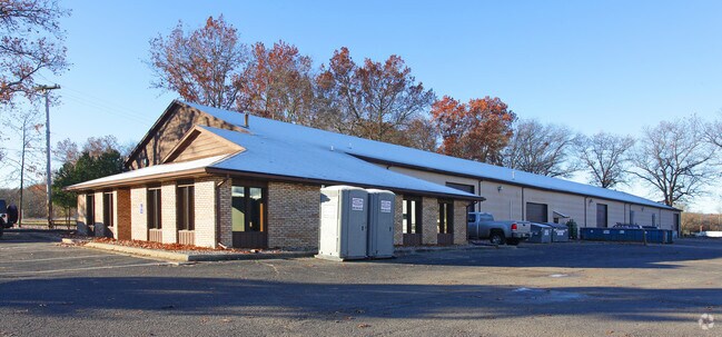
9350 Shaver Rd, Portage, MI 49024


Current Lease Availabilities
NEARBY LISTINGS FOR SALE OR LEASE
Property Detail
9350 Shaver Rd
10-00028-041-O
SEC 28-3-11 BEG AT A PT 441.71 FT N OF W 1/4 POST SEC 28, TH N 144 FT, TH E PAR N LI SD SEC 450.90 FT TO W LI SHAVER ROAD, TH
Commercialnec
Kalamazoo
X
Michigan
26077C0311E
1.39 AC
2025
Southern Kalamazoo County
2025
West Michigan
002002
Kalamazoo-Portage, MI
18,200 SF
DEMOGRAPHICS near 9350 Shaver Rd
1 Mile
3 Mile
5 Mile
2024 Total Population
2,103
29,152
66,453
2029 Population
2,103
29,033
66,095
Pop Growth 2024-2029
0.00%
(0.41%)
(0.54%)
Average Age
41
41
40
2024 Total Households
894
12,123
26,931
HH Growth 2024-2029
+ 0.11%
(0.40%)
(0.58%)
Median Household Inc
$74,867
$76,660
$75,704
Avg Household Size
2.30
2.30
2.40
2024 Avg HH Vehicles
2.00
2.00
2.00
Median Home Value
$232,758
$240,805
$240,051
Median Year Built
1979
1978
1978
Nearby Places
Map Layers
Map Styles
 Street
 Aerial
- Restaurants
- Banks
- Shops
- Fitness
- Groceries
PUBLIC TRANSPORTATION
COMMUTER RAIL
Kalamazoo (Blue Water - Amtrak, Wolverine - Amtrak)
DRIVE
WALK
Distance
Kalamazoo (Blue Water - Amtrak, Wolverine - Amtrak)
17 min
8.4 mi
AIRPORT
Kalamazoo/Battle Creek International
DRIVE
WALK
Distance
Kalamazoo/Battle Creek International
18 min
7.3 mi
Freight Ports
Port of Toledo
DRIVE
WALK
Distance
Port of Toledo
181 min
148.7 mi
Nearby Properties
Address
Land Use
TOTAL SIZE
Lot Size
Zoning
Address
Land Use
TOTAL SIZE
Lot Size
Zoning
383,638 SF
25.85 AC
B-2
Address
Land Use
TOTAL SIZE
Lot Size
Zoning
9.47 AC
Address
Land Use
TOTAL SIZE
Lot Size
Zoning
61,533 SF
8.42 AC
B-2
Address
Land Use
TOTAL SIZE
Lot Size
Zoning
18.57 AC
Address
Land Use
TOTAL SIZE
Lot Size
Zoning
1,776 SF
17 AC
PD
Address
Land Use
TOTAL SIZE
Lot Size
Zoning
16.58 AC
Address
Land Use
TOTAL SIZE
Lot Size
Zoning
6,874 SF
163.50 AC
PD
Address
Land Use
TOTAL SIZE
Lot Size
Zoning
151,395 SF
33.79 AC
CPD
Address
Land Use
TOTAL SIZE
Lot Size
Zoning
66.34 AC
B-3
Address
Land Use
TOTAL SIZE
Lot Size
Zoning
188,352 SF
67.55 AC
Address
Land Use
TOTAL SIZE
Lot Size
Zoning
32,094 SF
13.95 AC
PD
Address
Land Use
TOTAL SIZE
Lot Size
Zoning
21,180 SF
13.12 AC
RM-1
Address
Land Use
TOTAL SIZE
Lot Size
Zoning
20,760 SF
12.86 AC
RM-1
Address
Land Use
TOTAL SIZE
Lot Size
Zoning
9,246 SF
10.24 AC
RM-1
Address
Land Use
TOTAL SIZE
Lot Size
Zoning
168,173 SF
16.32 AC
I-2
Address
Land Use
TOTAL SIZE
Lot Size
Zoning
103,007 SF
8.02 AC
B-2
Address
Land Use
TOTAL SIZE
Lot Size
Zoning
8.92 AC
PD
Address
Land Use
TOTAL SIZE
Lot Size
Zoning
29,341 SF
5.72 AC
B-2
Address
Land Use
TOTAL SIZE
Lot Size
Zoning
26.89 AC
PD
Address
Land Use
TOTAL SIZE
Lot Size
Zoning
35,419 SF
6.70 AC
B-3
Address
Land Use
TOTAL SIZE
Lot Size
Zoning
120,324 SF
10.67 AC
OS-1
Address
Land Use
TOTAL SIZE
Lot Size
Zoning
40,964 SF
7.50 AC
PD
Address
Land Use
TOTAL SIZE
Lot Size
Zoning
9.85 AC
Address
Land Use
TOTAL SIZE
Lot Size
Zoning
137,106 SF
13.52 AC
RM-1
Address
Land Use
TOTAL SIZE
Lot Size
Zoning
7.57 AC
Address
Land Use
TOTAL SIZE
Lot Size
Zoning
135,548 SF
12.45 AC
CPD
Address
Land Use
TOTAL SIZE
Lot Size
Zoning
21,476 SF
8 AC
PD
Address
Land Use
TOTAL SIZE
Lot Size
Zoning
13,215 SF
2.91 AC
OS-1
Address
Land Use
TOTAL SIZE
Lot Size
Zoning
22,809 SF
6.80 AC
RM-1
Address
Land Use
TOTAL SIZE
Lot Size
Zoning
4.72 AC
OS-1
The World's #1 Commercial Real Estate Marketplace
Connect with us
© 2025 CoStar Group
The information above has been obtained from sources believed reliable. While we do not doubt its accuracy we have not verified it and make no guarantee, warranty or representation about it. It is your responsibility to independently confirm its accuracy and completeness. Any projections, opinions, assumptions, or estimates used are for example only and do not represent the current or future performance of the property. The value of this transaction to you depends on tax and other factors which should be evaluated by your tax, financial, and legal advisors. You and your advisors should conduct a careful, independent investigation of the property to determine to your satisfaction the suitability of the property for your needs.