Property Record
9357 Old State Hwy, Newcastle, CA 95658
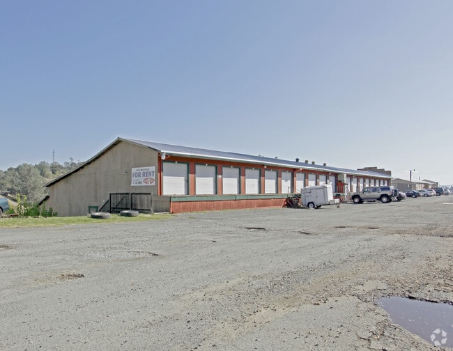
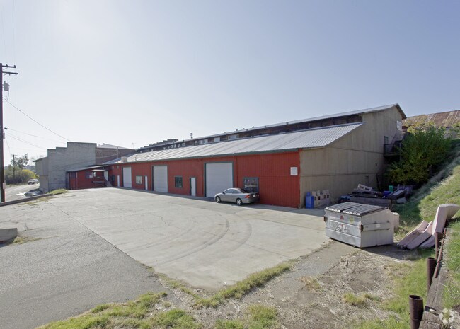
Property Detail
9357 Old State Hwy
040-178-002
LOT 8 BLK A RICE TR
Shipyard
PLACER
INDC
California
B and X Area of moderate flood hazard, usually the area between the limits of the 100-year and 500-year floods.
8
2024
0.39 AC
2025
Auburn/Newcastle
020501
Sacramento
43,805 SF
Sacramento-Roseville-Folsom, CA
NEARBY LISTINGS FOR SALE OR LEASE
DEMOGRAPHICS near 9357 Old State Hwy
1 mile
3 mile
5 mile
2025 Total Population
1,188
11,668
42,216
2030 Population
1,234
12,210
44,121
Pop Growth 2025-2030
+ 3.87%
+ 4.65%
+ 4.51%
Average Age
46
46
46
2025 Total Households
459
4,531
16,866
HH Growth 2025-2030
+ 3.92%
+ 4.68%
+ 4.55%
Median Household Inc
$120,601
$129,290
$100,217
Avg Household Size
2.50
2.50
2.40
2025 Avg HH Vehicles
2.00
2.00
2.00
Median Home Value
$723,684
$791,475
$733,950
Median Year Built
1976
1979
1980
Nearby Places
Map Layers
Map Styles
 Street
 Aerial
Layers
 Traffic
 Biking
Places
Listings with unknown addresses are not visible on the map
- Restaurants
- Banks
- Shops
- Fitness
- Groceries
PUBLIC TRANSPORTATION
COMMUTER RAIL
Auburn-Conheim (Capitol Corridor - Capitol Corridor Joint Powers Authority)
Drive
Walk
Distance
Auburn-Conheim (Capitol Corridor - Capitol Corridor Joint Powers Authority)
7 min
4.6 mi
Auburn Amtrak (Capitol Corridor - Amtrak)
Drive
Walk
Distance
Auburn Amtrak (Capitol Corridor - Amtrak)
7 min
4.6 mi
AIRPORT
Sacramento International
Drive
Walk
Distance
Sacramento International
46 min
36.4 mi
Freight Ports
Port of Stockton
Drive
Walk
Distance
Port of Stockton
88 min
76.6 mi
Nearby Properties
Address
Land Use
TOTAL SIZE
Lot Size
Zoning
Address
Land Use
TOTAL SIZE
Lot Size
Zoning
50,450 SF
2.60 AC
Address
Land Use
TOTAL SIZE
Lot Size
Zoning
63,378 SF
30.30 AC
Address
Land Use
TOTAL SIZE
Lot Size
Zoning
878 SF
0.28 AC
C2DC
Address
Land Use
TOTAL SIZE
Lot Size
Zoning
2,736 SF
0.55 AC
HSDC
Address
Land Use
TOTAL SIZE
Lot Size
Zoning
22,015 SF
1.90 AC
Address
Land Use
TOTAL SIZE
Lot Size
Zoning
6,932 SF
11.80 AC
RAB100
Address
Land Use
TOTAL SIZE
Lot Size
Zoning
6,083 SF
1.30 AC
Address
Land Use
TOTAL SIZE
Lot Size
Zoning
14,240 SF
2.80 AC
INDC
Address
Land Use
TOTAL SIZE
Lot Size
Zoning
29,500 SF
6.90 AC
INDC
Address
Land Use
TOTAL SIZE
Lot Size
Zoning
40,349 SF
7.80 AC
INDC
Address
Land Use
TOTAL SIZE
Lot Size
Zoning
10,956 SF
8.15 AC
INDC
Address
Land Use
TOTAL SIZE
Lot Size
Zoning
6,485 SF
0.73 AC
Address
Land Use
TOTAL SIZE
Lot Size
Zoning
9,952 SF
1 AC
Address
Land Use
TOTAL SIZE
Lot Size
Zoning
38,222 SF
10.70 AC
INDC
Address
Land Use
TOTAL SIZE
Lot Size
Zoning
9.20 AC
C3UPDC
Address
Land Use
TOTAL SIZE
Lot Size
Zoning
16,000 SF
3.10 AC
INDC
Address
Land Use
TOTAL SIZE
Lot Size
Zoning
5,654 SF
0.75 AC
Address
Land Use
TOTAL SIZE
Lot Size
Zoning
1,512 SF
0.76 AC
C2DC
Address
Land Use
TOTAL SIZE
Lot Size
Zoning
31,762 SF
0.46 AC
INDC
Address
Land Use
TOTAL SIZE
Lot Size
Zoning
24,566 SF
9.80 AC
INDC
Address
Land Use
TOTAL SIZE
Lot Size
Zoning
6,394 SF
1 AC
C2DH
Address
Land Use
TOTAL SIZE
Lot Size
Zoning
4,400 SF
0.61 AC
C2DC
Address
Land Use
TOTAL SIZE
Lot Size
Zoning
22,878 SF
22.80 AC
CPDAGDC
Address
Land Use
TOTAL SIZE
Lot Size
Zoning
3,443 SF
1 AC
Address
Land Use
TOTAL SIZE
Lot Size
Zoning
37.90 AC
RABX
Address
Land Use
TOTAL SIZE
Lot Size
Zoning
4,296 SF
1.40 AC
INDC
Address
Land Use
TOTAL SIZE
Lot Size
Zoning
54,400 SF
2.40 AC
INDC
The World's #1 Commercial Real Estate Marketplace
Connect with us
© 2026 CoStar Group
The information above has been obtained from sources believed reliable. While we do not doubt its accuracy we have not verified it and make no guarantee, warranty or representation about it. It is your responsibility to independently confirm its accuracy and completeness. Any projections, opinions, assumptions, or estimates used are for example only and do not represent the current or future performance of the property. The value of this transaction to you depends on tax and other factors which should be evaluated by your tax, financial, and legal advisors. You and your advisors should conduct a careful, independent investigation of the property to determine to your satisfaction the suitability of the property for your needs.