Property Record
937 Reinli St, Austin, TX 78751
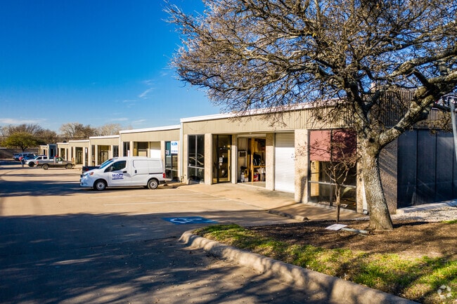

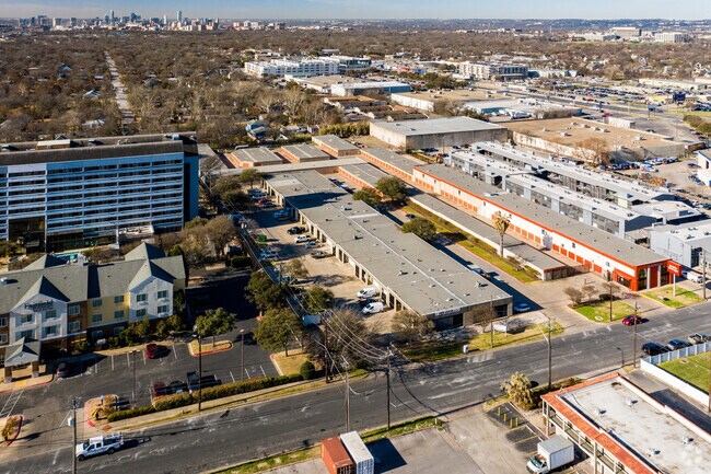
Property Detail
937 Reinli St
Austin-Round Rock-San Marcos, TX
LOT 1 DUVAL ANNEX
225473
TRAVIS
Publicstorage
Texas
AE The base floodplain where base flood elevations are provided. AE Zones are now used on new format FIRMs instead of A1-A30 Zones.
1
2025
5.09 AC
2025
Central
002105
Austin
106,510 SF
NEARBY LISTINGS FOR SALE OR LEASE
DEMOGRAPHICS near 937 Reinli St
1 mile
3 mile
5 mile
2025 Total Population
18,379
170,572
375,068
2030 Population
19,480
179,169
394,902
Pop Growth 2025-2030
+ 5.99%
+ 5.04%
+ 5.29%
Average Age
36
36
37
2025 Total Households
8,868
75,543
162,905
HH Growth 2025-2030
+ 6.65%
+ 5.87%
+ 6.15%
Median Household Inc
$78,206
$79,044
$86,846
Avg Household Size
2.00
2.10
2.10
2025 Avg HH Vehicles
1.00
2.00
2.00
Median Home Value
$634,369
$705,161
$711,716
Median Year Built
1979
1984
1988
Nearby Places
Map Layers
Map Styles
 Street
 Aerial
Layers
 Traffic
 Biking
Places
Listings with unknown addresses are not visible on the map
- Restaurants
- Banks
- Shops
- Fitness
- Groceries
PUBLIC TRANSPORTATION
COMMUTER RAIL
Drive
Walk
Distance
11 min
5.8 mi
AIRPORT
Austin-Bergstrom International
Drive
Walk
Distance
Austin-Bergstrom International
26 min
13.4 mi
SALE & LEASE HISTORY
LISTING DATE
SALE/LEASE

Sep 24, 2016
For Lease
Oct 16, 2018
For Lease
Jul 02, 2022
For Lease
Jan 05, 2017
For Lease
Nearby Properties
Address
Land Use
TOTAL SIZE
Lot Size
Zoning
Address
Land Use
TOTAL SIZE
Lot Size
Zoning
28.39 AC
Address
Land Use
TOTAL SIZE
Lot Size
Zoning
Address
Land Use
TOTAL SIZE
Lot Size
Zoning
28.62 AC
Address
Land Use
TOTAL SIZE
Lot Size
Zoning
27.17 AC
Address
Land Use
TOTAL SIZE
Lot Size
Zoning
30.96 AC
Address
Land Use
TOTAL SIZE
Lot Size
Zoning
18.52 AC
Address
Land Use
TOTAL SIZE
Lot Size
Zoning
74.69 AC
Address
Land Use
TOTAL SIZE
Lot Size
Zoning
548,399 SF
23.82 AC
Address
Land Use
TOTAL SIZE
Lot Size
Zoning
623,000 SF
11.78 AC
Address
Land Use
TOTAL SIZE
Lot Size
Zoning
21 AC
Address
Land Use
TOTAL SIZE
Lot Size
Zoning
614,532 SF
66.07 AC
Address
Land Use
TOTAL SIZE
Lot Size
Zoning
1,234 SF
96.75 AC
Address
Land Use
TOTAL SIZE
Lot Size
Zoning
11.61 AC
Address
Land Use
TOTAL SIZE
Lot Size
Zoning
263,226 SF
1.43 AC
Address
Land Use
TOTAL SIZE
Lot Size
Zoning
973,370 SF
11.26 AC
Address
Land Use
TOTAL SIZE
Lot Size
Zoning
22.14 AC
Address
Land Use
TOTAL SIZE
Lot Size
Zoning
11.11 AC
Address
Land Use
TOTAL SIZE
Lot Size
Zoning
14.55 AC
Address
Land Use
TOTAL SIZE
Lot Size
Zoning
510,500 SF
9.26 AC
Address
Land Use
TOTAL SIZE
Lot Size
Zoning
401,418 SF
4.77 AC
Address
Land Use
TOTAL SIZE
Lot Size
Zoning
Address
Land Use
TOTAL SIZE
Lot Size
Zoning
241,000 SF
0.40 AC
Address
Land Use
TOTAL SIZE
Lot Size
Zoning
19,284 SF
178.26 AC
Address
Land Use
TOTAL SIZE
Lot Size
Zoning
241,998 SF
2.42 AC
Address
Land Use
TOTAL SIZE
Lot Size
Zoning
238,650 SF
1.18 AC
Address
Land Use
TOTAL SIZE
Lot Size
Zoning
480,823 SF
18.46 AC
Address
Land Use
TOTAL SIZE
Lot Size
Zoning
322,150 SF
3.83 AC
Address
Land Use
TOTAL SIZE
Lot Size
Zoning
432,032 SF
6.70 AC
Address
Land Use
TOTAL SIZE
Lot Size
Zoning
609,823 SF
3.33 AC
The World's #1 Commercial Real Estate Marketplace
Connect with us
© 2026 CoStar Group
The information above has been obtained from sources believed reliable. While we do not doubt its accuracy we have not verified it and make no guarantee, warranty or representation about it. It is your responsibility to independently confirm its accuracy and completeness. Any projections, opinions, assumptions, or estimates used are for example only and do not represent the current or future performance of the property. The value of this transaction to you depends on tax and other factors which should be evaluated by your tax, financial, and legal advisors. You and your advisors should conduct a careful, independent investigation of the property to determine to your satisfaction the suitability of the property for your needs.