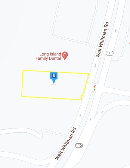
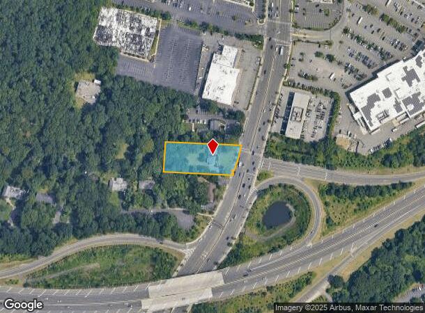
Property Record
937 Walt Whitman Rd, Melville, NY 11747
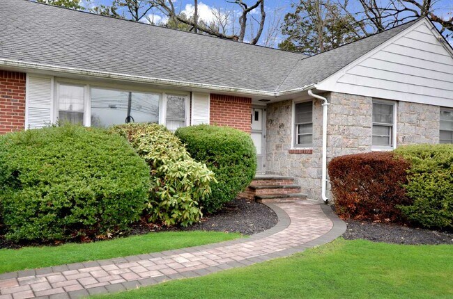
This Property Is For Sale
NEARBY LISTINGS FOR SALE OR LEASE
Property Detail
937 Walt Whitman Rd
Nassau County-Suffolk County, NY
Suffolk
0400-229-00-01-00-018-000
New York
Sfr
1 AC
X
Western Suffolk
36103C0620H
Long Island (New York)
DEMOGRAPHICS near 937 Walt Whitman Rd
1 Mile
3 Mile
5 Mile
2024 Total Population
6,665
53,676
206,625
2029 Population
6,553
52,746
203,015
Pop Growth 2024-2029
(1.68%)
(1.73%)
(1.75%)
Average Age
46
44
42
2024 Total Households
2,525
18,633
66,798
HH Growth 2024-2029
(1.74%)
(1.87%)
(1.89%)
Median Household Inc
$134,098
$138,598
$138,081
Avg Household Size
2.60
2.70
2.90
2024 Avg HH Vehicles
2.00
2.00
2.00
Median Home Value
$710,267
$710,743
$681,844
Median Year Built
1972
1965
1962
Nearby Places
- Restaurants
- Banks
- Shops
- Fitness
- Groceries
PUBLIC TRANSPORTATION
COMMUTER RAIL
Pinelawn Station (Ronkonkoma Branch - Long Island Rail Road)
DRIVE
WALK
Distance
Pinelawn Station (Ronkonkoma Branch - Long Island Rail Road)
7 min
4.0 mi
Cold Spring Harbor Station (Port Jefferson Branch - Long Island Rail Road)
DRIVE
WALK
Distance
Cold Spring Harbor Station (Port Jefferson Branch - Long Island Rail Road)
11 min
4.9 mi
AIRPORT
Long Island MacArthur
DRIVE
WALK
Distance
Long Island MacArthur
29 min
18.8 mi
LaGuardia
DRIVE
WALK
Distance
LaGuardia
41 min
27.8 mi
John F Kennedy International
DRIVE
WALK
Distance
John F Kennedy International
41 min
29.5 mi
Freight Ports
NY - Red Hook Container Terminal
DRIVE
WALK
Distance
NY - Red Hook Container Terminal
52 min
35.9 mi
Nearby Properties
Address
Land Use
TOTAL SIZE
Lot Size
Zoning
Address
Land Use
TOTAL SIZE
Lot Size
Zoning
37 AC
I2
Address
Land Use
TOTAL SIZE
Lot Size
Zoning
3.31 AC
R40
Address
Land Use
TOTAL SIZE
Lot Size
Zoning
16,520 SF
160.33 AC
Address
Land Use
TOTAL SIZE
Lot Size
Zoning
33.80 AC
Address
Land Use
TOTAL SIZE
Lot Size
Zoning
647,177 SF
51.88 AC
Address
Land Use
TOTAL SIZE
Lot Size
Zoning
52.10 AC
Address
Land Use
TOTAL SIZE
Lot Size
Zoning
37.20 AC
I2
Address
Land Use
TOTAL SIZE
Lot Size
Zoning
32.67 AC
R80
Address
Land Use
TOTAL SIZE
Lot Size
Zoning
82 AC
R40
Address
Land Use
TOTAL SIZE
Lot Size
Zoning
24.75 AC
R40
Address
Land Use
TOTAL SIZE
Lot Size
Zoning
183.15 AC
Address
Land Use
TOTAL SIZE
Lot Size
Zoning
11.50 AC
C10
Address
Land Use
TOTAL SIZE
Lot Size
Zoning
2.92 AC
R20
Address
Land Use
TOTAL SIZE
Lot Size
Zoning
12 AC
I1
Address
Land Use
TOTAL SIZE
Lot Size
Zoning
22.20 AC
I1
Address
Land Use
TOTAL SIZE
Lot Size
Zoning
14.40 AC
I1
Address
Land Use
TOTAL SIZE
Lot Size
Zoning
0.26 AC
R20
Address
Land Use
TOTAL SIZE
Lot Size
Zoning
32.60 AC
I1
Address
Land Use
TOTAL SIZE
Lot Size
Zoning
52.20 AC
R40
Address
Land Use
TOTAL SIZE
Lot Size
Zoning
16 AC
I1
Address
Land Use
TOTAL SIZE
Lot Size
Zoning
23.66 AC
I1
Address
Land Use
TOTAL SIZE
Lot Size
Zoning
21.50 AC
I1
Address
Land Use
TOTAL SIZE
Lot Size
Zoning
265.70 AC
R80
Address
Land Use
TOTAL SIZE
Lot Size
Zoning
21.10 AC
C5
Address
Land Use
TOTAL SIZE
Lot Size
Zoning
13.12 AC
R40
Address
Land Use
TOTAL SIZE
Lot Size
Zoning
33 AC
R40
Address
Land Use
TOTAL SIZE
Lot Size
Zoning
260,092 SF
7.07 AC
GA
Address
Land Use
TOTAL SIZE
Lot Size
Zoning
7.50 AC
C2
Address
Land Use
TOTAL SIZE
Lot Size
Zoning
30.30 AC
R40
Address
Land Use
TOTAL SIZE
Lot Size
Zoning
14.50 AC
C10
The World's #1 Commercial Real Estate Marketplace
Connect with us
© 2025 CoStar Group
The information above has been obtained from sources believed reliable. While we do not doubt its accuracy we have not verified it and make no guarantee, warranty or representation about it. It is your responsibility to independently confirm its accuracy and completeness. Any projections, opinions, assumptions, or estimates used are for example only and do not represent the current or future performance of the property. The value of this transaction to you depends on tax and other factors which should be evaluated by your tax, financial, and legal advisors. You and your advisors should conduct a careful, independent investigation of the property to determine to your satisfaction the suitability of the property for your needs.