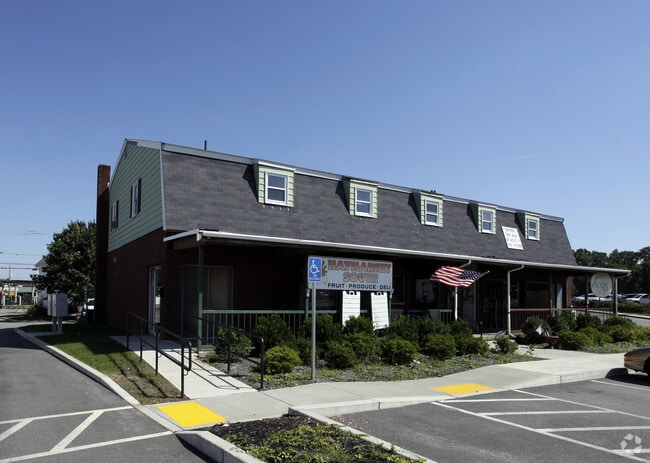
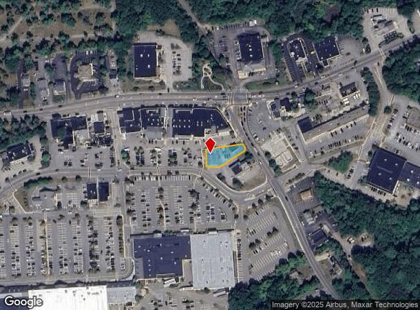
Property Record
937 Webster St, Marshfield, MA 02050

NEARBY LISTINGS FOR SALE OR LEASE
-
-
View all Marshfield listings for sale on LoopNet.com
Property Detail
937 Webster St
MARS-000007H-000004-000017
Bay Ave
Commercialofficeresidentialmixeduse
Plymouth
X
Massachusetts
25023C0229L
17
2025
0.26 AC
2025
Route 3 South
506202
Boston
6,900 SF
Boston-Cambridge-Newton, MA-NH
DEMOGRAPHICS near 937 Webster St
1 mile
3 mile
5 mile
2024 Total Population
3,211
24,459
44,611
2029 Population
3,211
24,591
44,691
Pop Growth 2024-2029
0.00%
+ 0.54%
+ 0.18%
Average Age
43
44
44
2024 Total Households
1,285
9,644
16,952
HH Growth 2024-2029
(0.08%)
+ 0.59%
+ 0.17%
Median Household Inc
$107,827
$115,431
$124,533
Avg Household Size
2.50
2.50
2.60
2024 Avg HH Vehicles
2.00
2.00
2.00
Median Home Value
$524,881
$577,712
$638,486
Median Year Built
1972
1971
1971
Nearby Places
Map Layers
Map Styles
 Street
 Aerial
Transit
 Traffic
 Biking
Places
Listings with unknown addresses are not visible on the map
- Restaurants
- Banks
- Shops
- Fitness
- Groceries
PUBLIC TRANSPORTATION
COMMUTER RAIL
Greenbush (Greenbush Line - Massachusetts Bay Transportation Authority Commuter Rail (Purple Line))
Drive
Walk
Distance
Greenbush (Greenbush Line - Massachusetts Bay Transportation Authority Commuter Rail (Purple Line))
13 min
7.5 mi
AIRPORT
General Edward Lawrence Logan International
Drive
Walk
Distance
General Edward Lawrence Logan International
47 min
32.2 mi
Nearby Properties
Address
Land Use
TOTAL SIZE
Lot Size
Zoning
Address
Land Use
TOTAL SIZE
Lot Size
Zoning
322,940 SF
21.19 AC
I-1
Address
Land Use
TOTAL SIZE
Lot Size
Zoning
178,072 SF
9.11 AC
I-1
Address
Land Use
TOTAL SIZE
Lot Size
Zoning
279,792 SF
51 AC
Address
Land Use
TOTAL SIZE
Lot Size
Zoning
182,609 SF
24.63 AC
Address
Land Use
TOTAL SIZE
Lot Size
Zoning
12,180 SF
10.80 AC
I-1
Address
Land Use
TOTAL SIZE
Lot Size
Zoning
92,781 SF
27.94 AC
B-2
Address
Land Use
TOTAL SIZE
Lot Size
Zoning
50,341 SF
7.05 AC
I-1
Address
Land Use
TOTAL SIZE
Lot Size
Zoning
108,457 SF
7.28 AC
B-2
Address
Land Use
TOTAL SIZE
Lot Size
Zoning
21,012 SF
1.91 AC
R-B
Address
Land Use
TOTAL SIZE
Lot Size
Zoning
66,308 SF
21.10 AC
Address
Land Use
TOTAL SIZE
Lot Size
Zoning
40,084 SF
12.80 AC
B-2
Address
Land Use
TOTAL SIZE
Lot Size
Zoning
7,408 SF
132.85 AC
RC
Address
Land Use
TOTAL SIZE
Lot Size
Zoning
57,324 SF
25.50 AC
R-2
Address
Land Use
TOTAL SIZE
Lot Size
Zoning
22,173 SF
62.99 AC
Address
Land Use
TOTAL SIZE
Lot Size
Zoning
24,358 SF
128.40 AC
R-3
Address
Land Use
TOTAL SIZE
Lot Size
Zoning
47,346 SF
6.30 AC
R-1
Address
Land Use
TOTAL SIZE
Lot Size
Zoning
473 AC
R-1
Address
Land Use
TOTAL SIZE
Lot Size
Zoning
70,233 SF
11.89 AC
R-2
Address
Land Use
TOTAL SIZE
Lot Size
Zoning
55,870 SF
129.15 AC
Address
Land Use
TOTAL SIZE
Lot Size
Zoning
24,003 SF
5.38 AC
R-2
Address
Land Use
TOTAL SIZE
Lot Size
Zoning
45,696 SF
2.76 AC
Address
Land Use
TOTAL SIZE
Lot Size
Zoning
45,696 SF
5.36 AC
Address
Land Use
TOTAL SIZE
Lot Size
Zoning
88,420 SF
4.80 AC
I-1
Address
Land Use
TOTAL SIZE
Lot Size
Zoning
40,272 SF
1.33 AC
B-1
Address
Land Use
TOTAL SIZE
Lot Size
Zoning
55,750 SF
5 AC
Address
Land Use
TOTAL SIZE
Lot Size
Zoning
29,341 SF
6.40 AC
I-1
Address
Land Use
TOTAL SIZE
Lot Size
Zoning
19,077 SF
96.50 AC
Address
Land Use
TOTAL SIZE
Lot Size
Zoning
90,000 SF
7.73 AC
I-1
Address
Land Use
TOTAL SIZE
Lot Size
Zoning
27,120 SF
2.82 AC
Address
Land Use
TOTAL SIZE
Lot Size
Zoning
36,149 SF
3.52 AC
B-2
The World's #1 Commercial Real Estate Marketplace
Connect with us
© 2026 CoStar Group
The information above has been obtained from sources believed reliable. While we do not doubt its accuracy we have not verified it and make no guarantee, warranty or representation about it. It is your responsibility to independently confirm its accuracy and completeness. Any projections, opinions, assumptions, or estimates used are for example only and do not represent the current or future performance of the property. The value of this transaction to you depends on tax and other factors which should be evaluated by your tax, financial, and legal advisors. You and your advisors should conduct a careful, independent investigation of the property to determine to your satisfaction the suitability of the property for your needs.