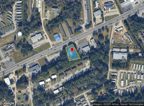
Property Record
938 Elma G Miles Pky, Hinesville, GA 31313
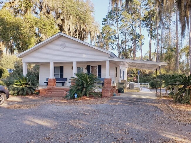
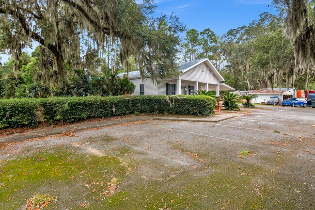
This Property Is For Sale
NEARBY LISTINGS FOR SALE OR LEASE
Property Detail
938 Elma G Miles Pky
046A-040
Gmass Commercial
Commercialnec
115.25X231.56 IRR OFF S R 196
X
Liberty
13179C0210E
Georgia
2024
0.66 AC
2024
Liberty County
010207
Savannah
1,326 SF
Hinesville, GA
DEMOGRAPHICS near 938 Elma G Miles Pky
1 Mile
3 Mile
5 Mile
2024 Total Population
7,227
34,345
56,448
2029 Population
7,477
35,933
60,582
Pop Growth 2024-2029
+ 3.46%
+ 4.62%
+ 7.32%
Average Age
33
33
32
2024 Total Households
2,783
12,994
19,604
HH Growth 2024-2029
+ 3.74%
+ 4.83%
+ 7.47%
Median Household Inc
$46,182
$47,653
$48,388
Avg Household Size
2.60
2.60
2.70
2024 Avg HH Vehicles
2.00
2.00
2.00
Median Home Value
$125,165
$149,796
$152,564
Median Year Built
1987
1991
1992
Nearby Places
- Restaurants
- Banks
- Shops
- Fitness
- Groceries
PUBLIC TRANSPORTATION
AIRPORT
Savannah/Hilton Head International
DRIVE
WALK
Distance
Savannah/Hilton Head International
60 min
41.0 mi
Nearby Properties
Address
Land Use
TOTAL SIZE
Lot Size
Zoning
Address
Land Use
TOTAL SIZE
Lot Size
Zoning
3,354 SF
58.90 AC
C3/R20
Address
Land Use
TOTAL SIZE
Lot Size
Zoning
258,552 SF
41.57 AC
PUD
Address
Land Use
TOTAL SIZE
Lot Size
Zoning
24,288 SF
12.05 AC
PUD
Address
Land Use
TOTAL SIZE
Lot Size
Zoning
102,939 SF
2.53 AC
C1
Address
Land Use
TOTAL SIZE
Lot Size
Zoning
148,364 SF
18.53 AC
PUD
Address
Land Use
TOTAL SIZE
Lot Size
Zoning
41,670 SF
1.89 AC
C1
Address
Land Use
TOTAL SIZE
Lot Size
Zoning
60,432 SF
23.64 AC
R20
Address
Land Use
TOTAL SIZE
Lot Size
Zoning
100,765 SF
33.20 AC
C2
Address
Land Use
TOTAL SIZE
Lot Size
Zoning
11,944 SF
39.41 AC
LI
Address
Land Use
TOTAL SIZE
Lot Size
Zoning
90,886 SF
10.78 AC
C2
Address
Land Use
TOTAL SIZE
Lot Size
Zoning
81,366 SF
28.01 AC
R20
Address
Land Use
TOTAL SIZE
Lot Size
Zoning
1,884 SF
9.25 AC
C2
Address
Land Use
TOTAL SIZE
Lot Size
Zoning
81,366 SF
35.17 AC
R8
Address
Land Use
TOTAL SIZE
Lot Size
Zoning
81,366 SF
16.50 AC
R20
Address
Land Use
TOTAL SIZE
Lot Size
Zoning
205,730 SF
21.03 AC
C3
Address
Land Use
TOTAL SIZE
Lot Size
Zoning
71,899 SF
50.12 AC
LI
Address
Land Use
TOTAL SIZE
Lot Size
Zoning
57,980 SF
10.72 AC
C2
Address
Land Use
TOTAL SIZE
Lot Size
Zoning
155,001 SF
10.56 AC
MFR
Address
Land Use
TOTAL SIZE
Lot Size
Zoning
105,967 SF
11.18 AC
C2
Address
Land Use
TOTAL SIZE
Lot Size
Zoning
110,150 SF
14.83 AC
C3
Address
Land Use
TOTAL SIZE
Lot Size
Zoning
133,379 SF
15.59 AC
C2
Address
Land Use
TOTAL SIZE
Lot Size
Zoning
27,627 SF
4.97 AC
C2
Address
Land Use
TOTAL SIZE
Lot Size
Zoning
42,572 SF
5.27 AC
C2
Address
Land Use
TOTAL SIZE
Lot Size
Zoning
34,334 SF
7.10 AC
C2
Address
Land Use
TOTAL SIZE
Lot Size
Zoning
12,261 SF
10.99 AC
C2
Address
Land Use
TOTAL SIZE
Lot Size
Zoning
39,252 SF
4.93 AC
MFR
Address
Land Use
TOTAL SIZE
Lot Size
Zoning
42,110 SF
5.86 AC
C3
Address
Land Use
TOTAL SIZE
Lot Size
Zoning
14,274 SF
6.34 AC
MFR
Address
Land Use
TOTAL SIZE
Lot Size
Zoning
24,144 SF
9.24 AC
C3
The World's #1 Commercial Real Estate Marketplace
Connect with us
© 2025 CoStar Group
The information above has been obtained from sources believed reliable. While we do not doubt its accuracy we have not verified it and make no guarantee, warranty or representation about it. It is your responsibility to independently confirm its accuracy and completeness. Any projections, opinions, assumptions, or estimates used are for example only and do not represent the current or future performance of the property. The value of this transaction to you depends on tax and other factors which should be evaluated by your tax, financial, and legal advisors. You and your advisors should conduct a careful, independent investigation of the property to determine to your satisfaction the suitability of the property for your needs.