Property Record
939 Ridge Rd, Monmouth Junction, NJ 08852
NEARBY LISTINGS FOR SALE OR LEASE
Property Detail
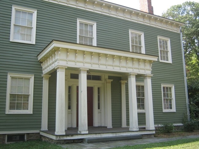
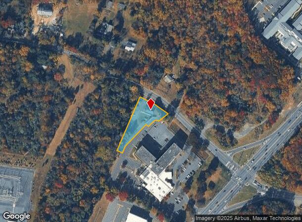
939 Ridge Rd
New York-Jersey City-White Plains, NY-NJ
Sassman-Holiday Inn South
21-00099-0000-00011-162
0.782 AC. OFFICE BLDG.
Officebuilding
Middlesex
X
New Jersey
34035C0301F
11.16
2024
0.78 AC
2025
Brunswick West
008504
Northern New Jersey
3,107 SF
DEMOGRAPHICS near 939 Ridge Rd
1 Mile
3 Mile
5 Mile
2024 Total Population
1,928
38,025
114,661
2029 Population
1,892
37,756
114,295
Pop Growth 2024-2029
(1.87%)
(0.71%)
(0.32%)
Average Age
44
42
40
2024 Total Households
741
14,437
41,664
HH Growth 2024-2029
(2.02%)
(0.80%)
(0.30%)
Median Household Inc
$94,335
$136,507
$137,134
Avg Household Size
2.50
2.60
2.70
2024 Avg HH Vehicles
2.00
2.00
2.00
Median Home Value
$616,894
$675,252
$629,380
Median Year Built
1978
1984
1986
Nearby Places
Map Layers
Map Styles
 Street
 Aerial
- Restaurants
- Banks
- Shops
- Fitness
- Groceries
PUBLIC TRANSPORTATION
COMMUTER RAIL
Princeton Junction (Northeast Corridor Line - NJ Transit Commuter Rail (NJ Transit), Princeton Branch - NJ Transit Commuter Rail (NJ Transit))
DRIVE
WALK
Distance
Princeton Junction (Northeast Corridor Line - NJ Transit Commuter Rail (NJ Transit), Princeton Branch - NJ Transit Commuter Rail (NJ Transit))
8 min
4.9 mi
Princeton (Princeton Branch - NJ Transit Commuter Rail (NJ Transit))
DRIVE
WALK
Distance
Princeton (Princeton Branch - NJ Transit Commuter Rail (NJ Transit))
8 min
5.3 mi
AIRPORT
Trenton Mercer
DRIVE
WALK
Distance
Trenton Mercer
23 min
16.8 mi
Freight Ports
New York Container Terminal
DRIVE
WALK
Distance
New York Container Terminal
45 min
32.0 mi
Nearby Properties
Address
Land Use
TOTAL SIZE
Lot Size
Zoning
Address
Land Use
TOTAL SIZE
Lot Size
Zoning
636,000 SF
60.76 AC
PHCR
Address
Land Use
TOTAL SIZE
Lot Size
Zoning
58.63 AC
PMUD
Address
Land Use
TOTAL SIZE
Lot Size
Zoning
51.70 AC
PCD
Address
Land Use
TOTAL SIZE
Lot Size
Zoning
52.74 AC
PCD
Address
Land Use
TOTAL SIZE
Lot Size
Zoning
492,110 SF
58.48 AC
I100
Address
Land Use
TOTAL SIZE
Lot Size
Zoning
46.23 AC
PCD
Address
Land Use
TOTAL SIZE
Lot Size
Zoning
50.08 AC
PMUD
Address
Land Use
TOTAL SIZE
Lot Size
Zoning
75.55 AC
PL
Address
Land Use
TOTAL SIZE
Lot Size
Zoning
34.97 AC
PMUD
Address
Land Use
TOTAL SIZE
Lot Size
Zoning
23.64 AC
PMUD
Address
Land Use
TOTAL SIZE
Lot Size
Zoning
23.63 AC
PCD
Address
Land Use
TOTAL SIZE
Lot Size
Zoning
25.66 AC
PHCR
Address
Land Use
TOTAL SIZE
Lot Size
Zoning
115,000 SF
7.98 AC
OR2
Address
Land Use
TOTAL SIZE
Lot Size
Zoning
216,000 SF
22.79 AC
SC
Address
Land Use
TOTAL SIZE
Lot Size
Zoning
66.62 AC
PMUD
Address
Land Use
TOTAL SIZE
Lot Size
Zoning
225,407 SF
22 AC
PMUD
Address
Land Use
TOTAL SIZE
Lot Size
Zoning
0.78 AC
PHCR
Address
Land Use
TOTAL SIZE
Lot Size
Zoning
11.75 AC
PMUD
Address
Land Use
TOTAL SIZE
Lot Size
Zoning
8.27 AC
PMUD
Address
Land Use
TOTAL SIZE
Lot Size
Zoning
264,792 SF
23.62 AC
PMUD
Address
Land Use
TOTAL SIZE
Lot Size
Zoning
178,000 SF
17.67 AC
PMUD
Address
Land Use
TOTAL SIZE
Lot Size
Zoning
241,468 SF
21.36 AC
PMUD
Address
Land Use
TOTAL SIZE
Lot Size
Zoning
154,150 SF
16.75 AC
PMUD
Address
Land Use
TOTAL SIZE
Lot Size
Zoning
9.73 AC
PMUD
Address
Land Use
TOTAL SIZE
Lot Size
Zoning
6.10 AC
PHCR
Address
Land Use
TOTAL SIZE
Lot Size
Zoning
12.59 AC
PMUD
Address
Land Use
TOTAL SIZE
Lot Size
Zoning
207.40 AC
OR
Address
Land Use
TOTAL SIZE
Lot Size
Zoning
12.03 AC
PMUD
Address
Land Use
TOTAL SIZE
Lot Size
Zoning
38.95 AC
R100
Address
Land Use
TOTAL SIZE
Lot Size
Zoning
30.02 AC
OB-1
The World's #1 Commercial Real Estate Marketplace
Connect with us
© 2025 CoStar Group
The information above has been obtained from sources believed reliable. While we do not doubt its accuracy we have not verified it and make no guarantee, warranty or representation about it. It is your responsibility to independently confirm its accuracy and completeness. Any projections, opinions, assumptions, or estimates used are for example only and do not represent the current or future performance of the property. The value of this transaction to you depends on tax and other factors which should be evaluated by your tax, financial, and legal advisors. You and your advisors should conduct a careful, independent investigation of the property to determine to your satisfaction the suitability of the property for your needs.