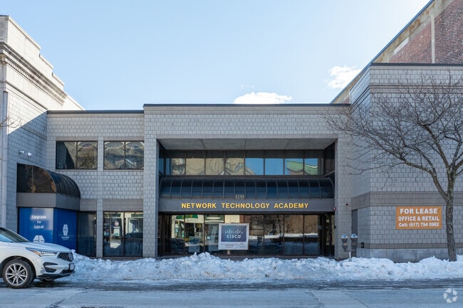
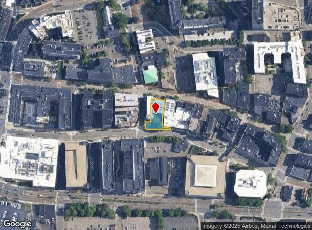
Property Record
100 Pleasant St, Malden, MA 02148
Current Lease Availabilities
NEARBY LISTINGS FOR SALE OR LEASE
Property Detail
100 Pleasant St
MALD-000052-000274-000402
Middlesex
Officebuilding
Massachusetts
X
402
25017C0437F
0.24 AC
2025
Medford/Malden
2025
Boston
341301
Boston-Cambridge-Newton, MA-NH
10,924 SF
DEMOGRAPHICS near 100 Pleasant St
1 Mile
3 Mile
5 Mile
2024 Total Population
43,909
246,036
663,710
2029 Population
42,599
238,761
644,869
Pop Growth 2024-2029
(2.98%)
(2.96%)
(2.84%)
Average Age
39
39
39
2024 Total Households
17,365
95,305
272,097
HH Growth 2024-2029
(2.87%)
(2.93%)
(2.88%)
Median Household Inc
$79,231
$91,052
$100,260
Avg Household Size
2.40
2.50
2.30
2024 Avg HH Vehicles
1.00
1.00
1.00
Median Home Value
$638,442
$652,159
$730,298
Median Year Built
1948
1949
1949
Nearby Places
Map Layers
Map Styles
 Street
 Aerial
- Restaurants
- Banks
- Shops
- Fitness
- Groceries
PUBLIC TRANSPORTATION
TRANSIT/SUBWAY
Malden Center Station (Orange Line - Massachusetts Bay Transportation Authority Subway (The T))
DRIVE
WALK
Distance
Malden Center Station (Orange Line - Massachusetts Bay Transportation Authority Subway (The T))
2 min
8 min
0.4 mi
Oak Grove Station (Orange Line - Massachusetts Bay Transportation Authority Subway (The T))
DRIVE
WALK
Distance
Oak Grove Station (Orange Line - Massachusetts Bay Transportation Authority Subway (The T))
4 min
16 min
0.8 mi
COMMUTER RAIL
Malden Center (Haverhill Line - Massachusetts Bay Transportation Authority Commuter Rail (Purple Line))
DRIVE
WALK
Distance
Malden Center (Haverhill Line - Massachusetts Bay Transportation Authority Commuter Rail (Purple Line))
2 min
8 min
0.4 mi
Wyoming Hill (Haverhill Line - Massachusetts Bay Transportation Authority Commuter Rail (Purple Line))
DRIVE
WALK
Distance
Wyoming Hill (Haverhill Line - Massachusetts Bay Transportation Authority Commuter Rail (Purple Line))
8 min
1.9 mi
AIRPORT
General Edward Lawrence Logan International
DRIVE
WALK
Distance
General Edward Lawrence Logan International
23 min
8.8 mi
Manchester Boston Regional
DRIVE
WALK
Distance
Manchester Boston Regional
60 min
49.6 mi
Nearby Properties
Address
Land Use
TOTAL SIZE
Lot Size
Zoning
Address
Land Use
TOTAL SIZE
Lot Size
Zoning
47.67 AC
UN
Address
Land Use
TOTAL SIZE
Lot Size
Zoning
8 AC
HB
Address
Land Use
TOTAL SIZE
Lot Size
Zoning
646,546 SF
89.28 AC
ROD
Address
Land Use
TOTAL SIZE
Lot Size
Zoning
386,825 SF
10.67 AC
Address
Land Use
TOTAL SIZE
Lot Size
Zoning
410,642 SF
4.68 AC
CTED
Address
Land Use
TOTAL SIZE
Lot Size
Zoning
43.90 AC
Address
Land Use
TOTAL SIZE
Lot Size
Zoning
234,450 SF
3.49 AC
I
Address
Land Use
TOTAL SIZE
Lot Size
Zoning
297,396 SF
2.79 AC
CTED
Address
Land Use
TOTAL SIZE
Lot Size
Zoning
Address
Land Use
TOTAL SIZE
Lot Size
Zoning
530,113 SF
29.43 AC
Address
Land Use
TOTAL SIZE
Lot Size
Zoning
6.73 AC
HB
Address
Land Use
TOTAL SIZE
Lot Size
Zoning
13.48 AC
Address
Land Use
TOTAL SIZE
Lot Size
Zoning
254,075 SF
3.70 AC
Address
Land Use
TOTAL SIZE
Lot Size
Zoning
613,125 SF
15.74 AC
RC
Address
Land Use
TOTAL SIZE
Lot Size
Zoning
21,024 SF
18.19 AC
Address
Land Use
TOTAL SIZE
Lot Size
Zoning
253,859 SF
3.18 AC
Address
Land Use
TOTAL SIZE
Lot Size
Zoning
454,752 SF
6.22 AC
Address
Land Use
TOTAL SIZE
Lot Size
Zoning
7,736 SF
24.56 AC
UR
Address
Land Use
TOTAL SIZE
Lot Size
Zoning
129,898 SF
43.82 AC
ID
Address
Land Use
TOTAL SIZE
Lot Size
Zoning
Address
Land Use
TOTAL SIZE
Lot Size
Zoning
359,892 SF
9.06 AC
Address
Land Use
TOTAL SIZE
Lot Size
Zoning
252,796 SF
2.46 AC
ASMD
Address
Land Use
TOTAL SIZE
Lot Size
Zoning
354,723 SF
20.59 AC
BPA
Address
Land Use
TOTAL SIZE
Lot Size
Zoning
292,515 SF
21.61 AC
Address
Land Use
TOTAL SIZE
Lot Size
Zoning
362,358 SF
3.44 AC
CTED
Address
Land Use
TOTAL SIZE
Lot Size
Zoning
379,857 SF
7.16 AC
R2
Address
Land Use
TOTAL SIZE
Lot Size
Zoning
4.29 AC
RB
Address
Land Use
TOTAL SIZE
Lot Size
Zoning
0.47 AC
M
Address
Land Use
TOTAL SIZE
Lot Size
Zoning
232,943 SF
3.87 AC
Address
Land Use
TOTAL SIZE
Lot Size
Zoning
227,673 SF
1.75 AC
R3
The World's #1 Commercial Real Estate Marketplace
Connect with us
© 2026 CoStar Group
The information above has been obtained from sources believed reliable. While we do not doubt its accuracy we have not verified it and make no guarantee, warranty or representation about it. It is your responsibility to independently confirm its accuracy and completeness. Any projections, opinions, assumptions, or estimates used are for example only and do not represent the current or future performance of the property. The value of this transaction to you depends on tax and other factors which should be evaluated by your tax, financial, and legal advisors. You and your advisors should conduct a careful, independent investigation of the property to determine to your satisfaction the suitability of the property for your needs.