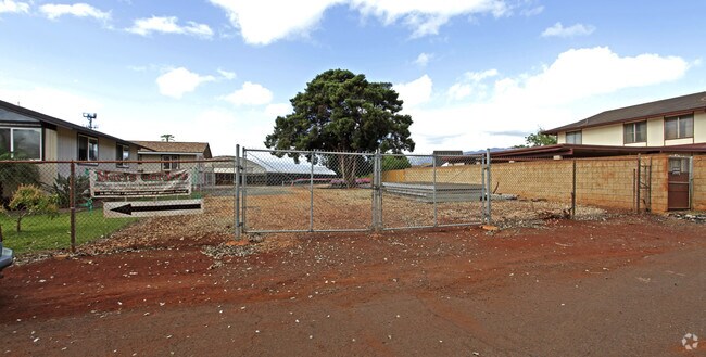
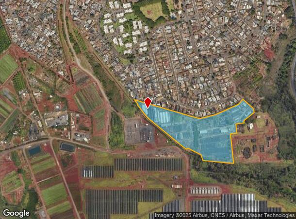
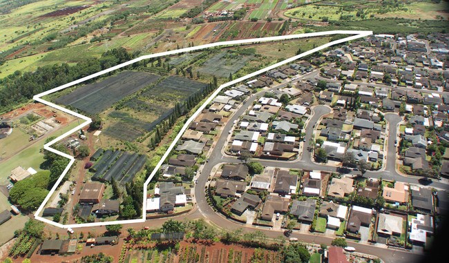
Property Record
94-415 Makapipipi St, Mililani, HI 96789

NEARBY LISTINGS FOR SALE OR LEASE
Property Detail
94-415 Makapipipi St
Urban Honolulu, HI
Watanabe Floral
1-9-4-005-069-0000
LOT 6434 17.565 ACS MAP 466 LCAPP 1000 SUBJ/ESMTS
Agriculturalland
Honolulu
D
Hawaii
15003C0236G
6434
2024
17.57 AC
2025
Central Oahu
008933
Hawaii
4,731 SF
DEMOGRAPHICS near 94-415 Makapipipi St
1 Mile
3 Mile
5 Mile
2024 Total Population
10,772
69,628
156,872
2029 Population
10,116
66,062
150,214
Pop Growth 2024-2029
(6.09%)
(5.12%)
(4.24%)
Average Age
43
41
41
2024 Total Households
3,369
21,193
47,882
HH Growth 2024-2029
(7.15%)
(6.02%)
(4.99%)
Median Household Inc
$119,228
$104,758
$99,539
Avg Household Size
3.10
3.10
3.10
2024 Avg HH Vehicles
2.00
2.00
2.00
Median Home Value
$747,058
$694,579
$703,473
Median Year Built
1976
1982
1980
Nearby Places
Map Layers
Map Styles
 Street
 Aerial
- Restaurants
- Banks
- Shops
- Fitness
- Groceries
PUBLIC TRANSPORTATION
AIRPORT
Daniel K Inouye International
DRIVE
WALK
Distance
Daniel K Inouye International
25 min
14.1 mi
Freight Ports
Honolulu Harbor, Oahu
DRIVE
WALK
Distance
Honolulu Harbor, Oahu
34 min
18.2 mi
Nearby Properties
Address
Land Use
TOTAL SIZE
Lot Size
Zoning
Address
Land Use
TOTAL SIZE
Lot Size
Zoning
376,136 SF
32.06 AC
B-2
Address
Land Use
TOTAL SIZE
Lot Size
Zoning
227,309 SF
16.77 AC
B-2
Address
Land Use
TOTAL SIZE
Lot Size
Zoning
8,600 SF
479.12 AC
F-1
Address
Land Use
TOTAL SIZE
Lot Size
Zoning
196,140 SF
17.74 AC
B-2
Address
Land Use
TOTAL SIZE
Lot Size
Zoning
260,997 SF
9.79 AC
I-2
Address
Land Use
TOTAL SIZE
Lot Size
Zoning
467,874 SF
15.30 AC
IMX-1
Address
Land Use
TOTAL SIZE
Lot Size
Zoning
121,310 SF
10.97 AC
B-2
Address
Land Use
TOTAL SIZE
Lot Size
Zoning
102,877 SF
9.77 AC
B-2
Address
Land Use
TOTAL SIZE
Lot Size
Zoning
38,400 SF
19.30 AC
AG-1
Address
Land Use
TOTAL SIZE
Lot Size
Zoning
424,593 SF
8.73 AC
B-2
Address
Land Use
TOTAL SIZE
Lot Size
Zoning
129,731 SF
8.45 AC
B-2
Address
Land Use
TOTAL SIZE
Lot Size
Zoning
5.87 AC
IMX-1
Address
Land Use
TOTAL SIZE
Lot Size
Zoning
128,870 SF
6.28 AC
IMX-1
Address
Land Use
TOTAL SIZE
Lot Size
Zoning
119,778 SF
4.55 AC
B-1
Address
Land Use
TOTAL SIZE
Lot Size
Zoning
116,556 SF
4.59 AC
I-2
Address
Land Use
TOTAL SIZE
Lot Size
Zoning
112,016 SF
4.28 AC
I-2
Address
Land Use
TOTAL SIZE
Lot Size
Zoning
21,580 SF
4.77 AC
B-2
Address
Land Use
TOTAL SIZE
Lot Size
Zoning
132,108 SF
4.37 AC
B-2
Address
Land Use
TOTAL SIZE
Lot Size
Zoning
102,880 SF
3.84 AC
I-2
Address
Land Use
TOTAL SIZE
Lot Size
Zoning
52,382 SF
3.13 AC
I-2
Address
Land Use
TOTAL SIZE
Lot Size
Zoning
125,748 SF
2.94 AC
I-2
Address
Land Use
TOTAL SIZE
Lot Size
Zoning
70,807 SF
4.31 AC
B-2
Address
Land Use
TOTAL SIZE
Lot Size
Zoning
51,740 SF
3 AC
I-1
Address
Land Use
TOTAL SIZE
Lot Size
Zoning
40,272 SF
4.81 AC
IMX-1
Address
Land Use
TOTAL SIZE
Lot Size
Zoning
81,477 SF
2.08 AC
I-2
Address
Land Use
TOTAL SIZE
Lot Size
Zoning
49,140 SF
1.33 AC
B-2
Address
Land Use
TOTAL SIZE
Lot Size
Zoning
72,481 SF
2.28 AC
I-2
Address
Land Use
TOTAL SIZE
Lot Size
Zoning
39,600 SF
3.03 AC
B-2
Address
Land Use
TOTAL SIZE
Lot Size
Zoning
37,541 SF
4.21 AC
B-1
Address
Land Use
TOTAL SIZE
Lot Size
Zoning
69,616 SF
2.88 AC
I-2
The World's #1 Commercial Real Estate Marketplace
Connect with us
© 2025 CoStar Group
The information above has been obtained from sources believed reliable. While we do not doubt its accuracy we have not verified it and make no guarantee, warranty or representation about it. It is your responsibility to independently confirm its accuracy and completeness. Any projections, opinions, assumptions, or estimates used are for example only and do not represent the current or future performance of the property. The value of this transaction to you depends on tax and other factors which should be evaluated by your tax, financial, and legal advisors. You and your advisors should conduct a careful, independent investigation of the property to determine to your satisfaction the suitability of the property for your needs.