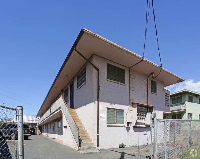
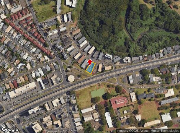
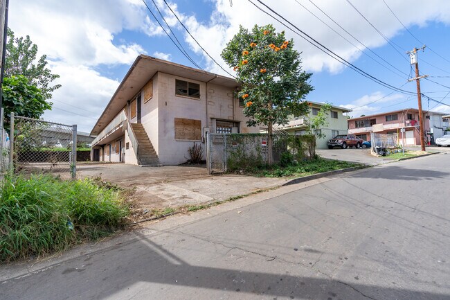
Property Record
94 Aniani Pl, Waipahu, HI 96797

NEARBY LISTINGS FOR SALE OR LEASE
Property Detail
94 Aniani Pl
Urban Honolulu, HI
Waikele Subd
1-9-4-025-038-0000
Honolulu
Sfr
Hawaii
X
0.20 AC
15003C0238G
Waipahu
5,980 SF
Hawaii
DEMOGRAPHICS near 94 Aniani Pl
1 Mile
3 Mile
5 Mile
2024 Total Population
22,581
79,814
206,713
2029 Population
21,473
76,100
197,026
Pop Growth 2024-2029
(4.91%)
(4.65%)
(4.69%)
Average Age
39
39
39
2024 Total Households
5,604
22,135
60,094
HH Growth 2024-2029
(5.59%)
(5.43%)
(5.45%)
Median Household Inc
$78,327
$95,079
$105,208
Avg Household Size
3.60
3.30
3.20
2024 Avg HH Vehicles
2.00
2.00
2.00
Median Home Value
$673,869
$685,252
$708,347
Median Year Built
1975
1986
1985
Nearby Places
Map Layers
Map Styles
 Street
 Aerial
- Restaurants
- Banks
- Shops
- Fitness
- Groceries
PUBLIC TRANSPORTATION
AIRPORT
Daniel K Inouye International
DRIVE
WALK
Distance
Daniel K Inouye International
17 min
10.7 mi
Freight Ports
Honolulu Harbor, Oahu
DRIVE
WALK
Distance
Honolulu Harbor, Oahu
25 min
14.9 mi
SALE & LEASE HISTORY
LISTING DATE
SALE/LEASE

Jan 27, 2023
For Sale
Nearby Properties
Address
Land Use
TOTAL SIZE
Lot Size
Zoning
Address
Land Use
TOTAL SIZE
Lot Size
Zoning
376,136 SF
32.06 AC
B-2
Address
Land Use
TOTAL SIZE
Lot Size
Zoning
227,309 SF
16.77 AC
B-2
Address
Land Use
TOTAL SIZE
Lot Size
Zoning
8,600 SF
479.12 AC
F-1
Address
Land Use
TOTAL SIZE
Lot Size
Zoning
82,948 SF
16.06 AC
AG-1
Address
Land Use
TOTAL SIZE
Lot Size
Zoning
229,396 SF
11.31 AC
BMX-3
Address
Land Use
TOTAL SIZE
Lot Size
Zoning
260,997 SF
9.79 AC
I-2
Address
Land Use
TOTAL SIZE
Lot Size
Zoning
2,225 SF
19.72 AC
AG-1
Address
Land Use
TOTAL SIZE
Lot Size
Zoning
729,528 SF
6.43 AC
BMX-3
Address
Land Use
TOTAL SIZE
Lot Size
Zoning
147,922 SF
16 AC
BMX-3
Address
Land Use
TOTAL SIZE
Lot Size
Zoning
102,877 SF
9.77 AC
B-2
Address
Land Use
TOTAL SIZE
Lot Size
Zoning
13.47 AC
AMX-2
Address
Land Use
TOTAL SIZE
Lot Size
Zoning
133,284 SF
11.74 AC
BMX-3
Address
Land Use
TOTAL SIZE
Lot Size
Zoning
424,593 SF
8.73 AC
B-2
Address
Land Use
TOTAL SIZE
Lot Size
Zoning
157,460 SF
9.51 AC
BMX-3
Address
Land Use
TOTAL SIZE
Lot Size
Zoning
108,786 SF
7.09 AC
BMX-3
Address
Land Use
TOTAL SIZE
Lot Size
Zoning
5,278 SF
57.87 AC
P-2
Address
Land Use
TOTAL SIZE
Lot Size
Zoning
9.44 AC
IMX-1
Address
Land Use
TOTAL SIZE
Lot Size
Zoning
53.41 AC
P-2
Address
Land Use
TOTAL SIZE
Lot Size
Zoning
45,606 SF
5.12 AC
BMX-3
Address
Land Use
TOTAL SIZE
Lot Size
Zoning
119,778 SF
4.55 AC
B-1
Address
Land Use
TOTAL SIZE
Lot Size
Zoning
131,855 SF
14.48 AC
AG-1
Address
Land Use
TOTAL SIZE
Lot Size
Zoning
67.86 AC
R-3.5
Address
Land Use
TOTAL SIZE
Lot Size
Zoning
7.81 AC
IMX-1
Address
Land Use
TOTAL SIZE
Lot Size
Zoning
68,487 SF
3.78 AC
R-5
Address
Land Use
TOTAL SIZE
Lot Size
Zoning
5.71 AC
A-2
Address
Land Use
TOTAL SIZE
Lot Size
Zoning
132,108 SF
4.37 AC
B-2
Address
Land Use
TOTAL SIZE
Lot Size
Zoning
57,170 SF
4.51 AC
BMX-3
Address
Land Use
TOTAL SIZE
Lot Size
Zoning
52,382 SF
3.13 AC
I-2
Address
Land Use
TOTAL SIZE
Lot Size
Zoning
125,748 SF
2.94 AC
I-2
Address
Land Use
TOTAL SIZE
Lot Size
Zoning
51,740 SF
3 AC
I-1
The World's #1 Commercial Real Estate Marketplace
Connect with us
© 2025 CoStar Group
The information above has been obtained from sources believed reliable. While we do not doubt its accuracy we have not verified it and make no guarantee, warranty or representation about it. It is your responsibility to independently confirm its accuracy and completeness. Any projections, opinions, assumptions, or estimates used are for example only and do not represent the current or future performance of the property. The value of this transaction to you depends on tax and other factors which should be evaluated by your tax, financial, and legal advisors. You and your advisors should conduct a careful, independent investigation of the property to determine to your satisfaction the suitability of the property for your needs.