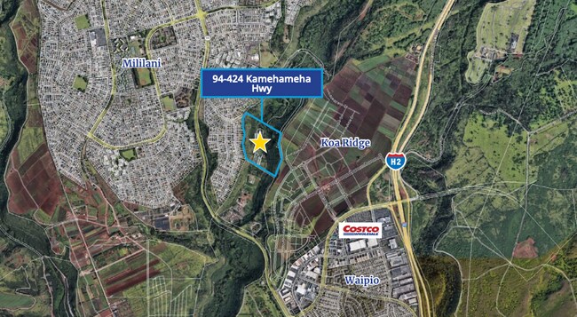
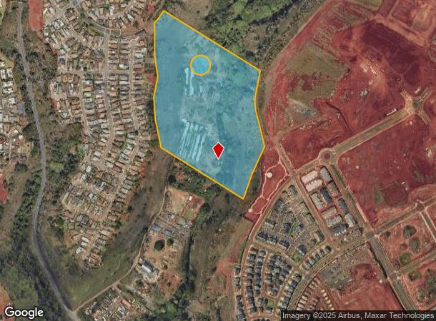
Property Record
94 Kamehameha Hwy, Mililani, HI 96789
NEARBY LISTINGS FOR SALE OR LEASE
Property Detail
94 Kamehameha Hwy
Urban Honolulu, HI
Map 451
1-9-4-005-010-0000
1ST: POR LCAW 8241 POR OLD GOVT RD EXCL 18 LCAPP 1000 2,767 SF (.063 AC) DES 2ND: POR LCAW 8241 POR OLD GOVT RD EXCL 18 LCAPP 1000
Agriculturalland
Honolulu
D
Hawaii
15003C0236G
942-a
2024
32.54 AC
2025
Central Oahu
008941
Hawaii
DEMOGRAPHICS near 94 Kamehameha Hwy
1 Mile
3 Mile
5 Mile
2024 Total Population
11,894
67,198
162,517
2029 Population
11,140
63,952
155,632
Pop Growth 2024-2029
(6.34%)
(4.83%)
(4.24%)
Average Age
42
41
41
2024 Total Households
3,803
21,478
49,713
HH Growth 2024-2029
(7.23%)
(5.70%)
(4.99%)
Median Household Inc
$111,797
$103,989
$99,694
Avg Household Size
3.00
3.00
3.10
2024 Avg HH Vehicles
2.00
2.00
2.00
Median Home Value
$730,595
$691,676
$702,991
Median Year Built
1976
1983
1979
Nearby Places
Map Layers
Map Styles
 Street
 Aerial
- Restaurants
- Banks
- Shops
- Fitness
- Groceries
PUBLIC TRANSPORTATION
AIRPORT
Daniel K Inouye International
DRIVE
WALK
Distance
Daniel K Inouye International
19 min
11.7 mi
Freight Ports
Honolulu Harbor, Oahu
DRIVE
WALK
Distance
Honolulu Harbor, Oahu
28 min
15.9 mi
Nearby Properties
Address
Land Use
TOTAL SIZE
Lot Size
Zoning
Address
Land Use
TOTAL SIZE
Lot Size
Zoning
376,136 SF
32.06 AC
B-2
Address
Land Use
TOTAL SIZE
Lot Size
Zoning
227,309 SF
16.77 AC
B-2
Address
Land Use
TOTAL SIZE
Lot Size
Zoning
8,600 SF
479.12 AC
F-1
Address
Land Use
TOTAL SIZE
Lot Size
Zoning
196,140 SF
17.74 AC
B-2
Address
Land Use
TOTAL SIZE
Lot Size
Zoning
260,997 SF
9.79 AC
I-2
Address
Land Use
TOTAL SIZE
Lot Size
Zoning
467,874 SF
15.30 AC
IMX-1
Address
Land Use
TOTAL SIZE
Lot Size
Zoning
121,310 SF
10.97 AC
B-2
Address
Land Use
TOTAL SIZE
Lot Size
Zoning
102,877 SF
9.77 AC
B-2
Address
Land Use
TOTAL SIZE
Lot Size
Zoning
129,731 SF
8.45 AC
B-2
Address
Land Use
TOTAL SIZE
Lot Size
Zoning
5.87 AC
IMX-1
Address
Land Use
TOTAL SIZE
Lot Size
Zoning
128,870 SF
6.28 AC
IMX-1
Address
Land Use
TOTAL SIZE
Lot Size
Zoning
45,606 SF
5.12 AC
BMX-3
Address
Land Use
TOTAL SIZE
Lot Size
Zoning
116,556 SF
4.59 AC
I-2
Address
Land Use
TOTAL SIZE
Lot Size
Zoning
112,016 SF
4.28 AC
I-2
Address
Land Use
TOTAL SIZE
Lot Size
Zoning
21,580 SF
4.77 AC
B-2
Address
Land Use
TOTAL SIZE
Lot Size
Zoning
102,880 SF
3.84 AC
I-2
Address
Land Use
TOTAL SIZE
Lot Size
Zoning
125,748 SF
2.94 AC
I-2
Address
Land Use
TOTAL SIZE
Lot Size
Zoning
70,807 SF
4.31 AC
B-2
Address
Land Use
TOTAL SIZE
Lot Size
Zoning
40,272 SF
4.81 AC
IMX-1
Address
Land Use
TOTAL SIZE
Lot Size
Zoning
81,477 SF
2.08 AC
I-2
Address
Land Use
TOTAL SIZE
Lot Size
Zoning
49,140 SF
1.33 AC
B-2
Address
Land Use
TOTAL SIZE
Lot Size
Zoning
72,481 SF
2.28 AC
I-2
Address
Land Use
TOTAL SIZE
Lot Size
Zoning
39,600 SF
3.03 AC
B-2
Address
Land Use
TOTAL SIZE
Lot Size
Zoning
37,541 SF
4.21 AC
B-1
Address
Land Use
TOTAL SIZE
Lot Size
Zoning
69,616 SF
2.88 AC
I-2
Address
Land Use
TOTAL SIZE
Lot Size
Zoning
56,233 SF
1.78 AC
I-2
Address
Land Use
TOTAL SIZE
Lot Size
Zoning
49,767 SF
2.92 AC
IMX-1
Address
Land Use
TOTAL SIZE
Lot Size
Zoning
25,003 SF
1.59 AC
I-2
Address
Land Use
TOTAL SIZE
Lot Size
Zoning
138,390 SF
4.61 AC
B-1
Address
Land Use
TOTAL SIZE
Lot Size
Zoning
79,520 SF
2.55 AC
I-2
The World's #1 Commercial Real Estate Marketplace
Connect with us
© 2025 CoStar Group
The information above has been obtained from sources believed reliable. While we do not doubt its accuracy we have not verified it and make no guarantee, warranty or representation about it. It is your responsibility to independently confirm its accuracy and completeness. Any projections, opinions, assumptions, or estimates used are for example only and do not represent the current or future performance of the property. The value of this transaction to you depends on tax and other factors which should be evaluated by your tax, financial, and legal advisors. You and your advisors should conduct a careful, independent investigation of the property to determine to your satisfaction the suitability of the property for your needs.