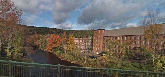
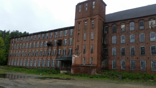
Property Record
94 Main St, Ware, MA 01082

Property Detail
94 Main St
HARD-000550-000000-000019
WORCESTER
Manufacturinglight
Massachusetts
I40
19-0
2025
5 AC
2025
Outlying Worcester
820101
Boston
112,484 SF
Worcester, MA
NEARBY LISTINGS FOR SALE OR LEASE
-
-
View all Ware listings for sale on LoopNet.com
DEMOGRAPHICS near 94 Main St
1 mile
3 mile
5 mile
2025 Total Population
1,056
3,054
11,449
2030 Population
1,080
3,082
11,502
Pop Growth 2025-2030
+ 2.27%
+ 0.92%
+ 0.46%
Average Age
42
44
43
2025 Total Households
447
1,256
4,823
HH Growth 2025-2030
+ 2.46%
+ 1.04%
+ 0.60%
Median Household Inc
$51,219
$77,348
$69,516
Avg Household Size
2.30
2.40
2.30
2025 Avg HH Vehicles
2.00
2.00
2.00
Median Home Value
$288,094
$356,115
$291,562
Median Year Built
1947
1959
1961
Nearby Places
Map Layers
Map Styles
 Street
 Aerial
Layers
 Traffic
 Biking
Places
Listings with unknown addresses are not visible on the map
- Restaurants
- Banks
- Shops
- Fitness
- Groceries
PUBLIC TRANSPORTATION
AIRPORT
Worcester Regional
Drive
Walk
Distance
Worcester Regional
43 min
23.3 mi
Freight Ports
Port of Boston
Drive
Walk
Distance
Port of Boston
107 min
71.7 mi
SALE & LEASE HISTORY
LISTING DATE
SALE/LEASE

Sep 23, 2016
For Sale
Jun 02, 2017
For Sale
Nearby Properties
Address
Land Use
TOTAL SIZE
Lot Size
Zoning
Address
Land Use
TOTAL SIZE
Lot Size
Zoning
45,593 SF
38.14 AC
R40
Address
Land Use
TOTAL SIZE
Lot Size
Zoning
7,405 SF
1.60 AC
GV
Address
Land Use
TOTAL SIZE
Lot Size
Zoning
784 SF
4.79 AC
I40
Address
Land Use
TOTAL SIZE
Lot Size
Zoning
2.91 AC
GV
Address
Land Use
TOTAL SIZE
Lot Size
Zoning
522.20 AC
AR60
Address
Land Use
TOTAL SIZE
Lot Size
Zoning
2,169 SF
1.65 AC
V
Address
Land Use
TOTAL SIZE
Lot Size
Zoning
4,160 SF
1.90 AC
V
Address
Land Use
TOTAL SIZE
Lot Size
Zoning
25,207 SF
3.31 AC
C40
Address
Land Use
TOTAL SIZE
Lot Size
Zoning
7,048 SF
77.98 AC
C40
Address
Land Use
TOTAL SIZE
Lot Size
Zoning
16,314 SF
1.66 AC
GV
Address
Land Use
TOTAL SIZE
Lot Size
Zoning
3,545 SF
0.97 AC
V
Address
Land Use
TOTAL SIZE
Lot Size
Zoning
4,672 SF
0.45 AC
GV
Address
Land Use
TOTAL SIZE
Lot Size
Zoning
0.17 AC
RR
Address
Land Use
TOTAL SIZE
Lot Size
Zoning
4,688 SF
5.17 AC
AR60
Address
Land Use
TOTAL SIZE
Lot Size
Zoning
63,561 SF
4.22 AC
I40
Address
Land Use
TOTAL SIZE
Lot Size
Zoning
713 SF
19.22 AC
R40
Address
Land Use
TOTAL SIZE
Lot Size
Zoning
125.40 AC
AR60
Address
Land Use
TOTAL SIZE
Lot Size
Zoning
6,028 SF
0.13 AC
V
Address
Land Use
TOTAL SIZE
Lot Size
Zoning
3,520 SF
1.61 AC
RB
Address
Land Use
TOTAL SIZE
Lot Size
Zoning
8,628 SF
0.62 AC
GV
Address
Land Use
TOTAL SIZE
Lot Size
Zoning
4,026 SF
8.60 AC
RR
Address
Land Use
TOTAL SIZE
Lot Size
Zoning
1,698 SF
2.08 AC
R1
Address
Land Use
TOTAL SIZE
Lot Size
Zoning
3,014 SF
3.56 AC
R40
Address
Land Use
TOTAL SIZE
Lot Size
Zoning
5,425 SF
0.25 AC
V
Address
Land Use
TOTAL SIZE
Lot Size
Zoning
7,545 SF
0.15 AC
GV
Address
Land Use
TOTAL SIZE
Lot Size
Zoning
5,380 SF
0.37 AC
GV
Address
Land Use
TOTAL SIZE
Lot Size
Zoning
1,550 SF
26.71 AC
R40
Address
Land Use
TOTAL SIZE
Lot Size
Zoning
1,578 SF
0.57 AC
AR60
Address
Land Use
TOTAL SIZE
Lot Size
Zoning
5,280 SF
0.27 AC
GV
The World's #1 Commercial Real Estate Marketplace
Connect with us
© 2026 CoStar Group
The information above has been obtained from sources believed reliable. While we do not doubt its accuracy we have not verified it and make no guarantee, warranty or representation about it. It is your responsibility to independently confirm its accuracy and completeness. Any projections, opinions, assumptions, or estimates used are for example only and do not represent the current or future performance of the property. The value of this transaction to you depends on tax and other factors which should be evaluated by your tax, financial, and legal advisors. You and your advisors should conduct a careful, independent investigation of the property to determine to your satisfaction the suitability of the property for your needs.