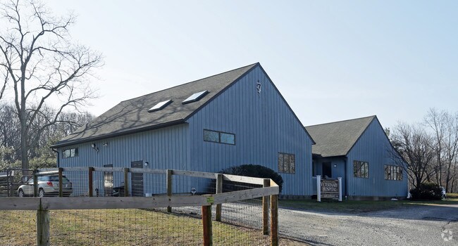
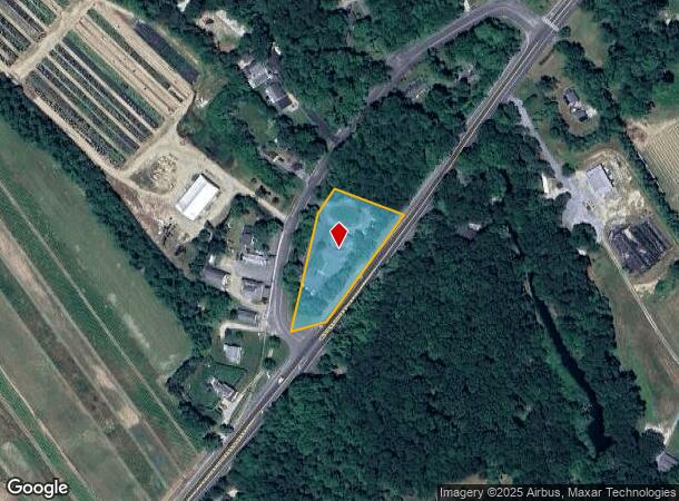
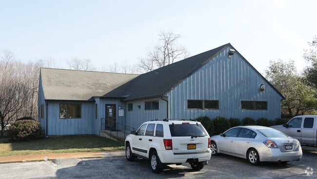
Property Record
940 Franklinville Rd, Laurel, NY 11948
NEARBY LISTINGS FOR SALE OR LEASE
Property Detail
940 Franklinville Rd
Nassau County-Suffolk County, NY
BOOK 11671 PAGE 020 BILL 016316
1000-127-00-02-00-005-001
Suffolk
Kennel
New York
X
5
36103C0483H
1.36 AC
2024
Eastern Suffolk
2024
Long Island (New York)
170003
DEMOGRAPHICS near 940 Franklinville Rd
1 Mile
3 Mile
5 Mile
2024 Total Population
903
7,911
16,014
2029 Population
920
7,874
15,991
Pop Growth 2024-2029
+ 1.88%
(0.47%)
(0.14%)
Average Age
45
47
45
2024 Total Households
332
3,154
6,144
HH Growth 2024-2029
+ 1.51%
(0.79%)
(0.50%)
Median Household Inc
$105,082
$103,838
$107,447
Avg Household Size
2.60
2.40
2.50
2024 Avg HH Vehicles
2.00
2.00
2.00
Median Home Value
$760,368
$737,500
$700,553
Median Year Built
1988
1976
1975
Nearby Places
- Restaurants
- Banks
- Shops
- Fitness
- Groceries
PUBLIC TRANSPORTATION
COMMUTER RAIL
Mattituck Station (Greenport Branch - Long Island Rail Road)
DRIVE
WALK
Distance
Mattituck Station (Greenport Branch - Long Island Rail Road)
4 min
2.4 mi
Riverhead Station (Greenport Branch - Long Island Rail Road)
DRIVE
WALK
Distance
Riverhead Station (Greenport Branch - Long Island Rail Road)
14 min
7.3 mi
Freight Ports
Port of New Haven
DRIVE
WALK
Distance
Port of New Haven
158 min
66.0 mi
Nearby Properties
Address
Land Use
TOTAL SIZE
Lot Size
Zoning
Address
Land Use
TOTAL SIZE
Lot Size
Zoning
214.30 AC
10
Address
Land Use
TOTAL SIZE
Lot Size
Zoning
30.40 AC
R-80
Address
Land Use
TOTAL SIZE
Lot Size
Zoning
1,688 SF
34.47 AC
09
Address
Land Use
TOTAL SIZE
Lot Size
Zoning
5.01 AC
10
Address
Land Use
TOTAL SIZE
Lot Size
Zoning
5,338 SF
159.30 AC
4
Address
Land Use
TOTAL SIZE
Lot Size
Zoning
11.39 AC
10
Address
Land Use
TOTAL SIZE
Lot Size
Zoning
1,980 SF
63.11 AC
09
Address
Land Use
TOTAL SIZE
Lot Size
Zoning
13,943 SF
4.40 AC
04
Address
Land Use
TOTAL SIZE
Lot Size
Zoning
2,928 SF
85.90 AC
04
Address
Land Use
TOTAL SIZE
Lot Size
Zoning
10,876 SF
4.80 AC
04
Address
Land Use
TOTAL SIZE
Lot Size
Zoning
2,588 SF
107.80 AC
03
Address
Land Use
TOTAL SIZE
Lot Size
Zoning
8,891 SF
2.91 AC
4
Address
Land Use
TOTAL SIZE
Lot Size
Zoning
24,898 SF
3.80 AC
4
Address
Land Use
TOTAL SIZE
Lot Size
Zoning
392 SF
52.39 AC
09
Address
Land Use
TOTAL SIZE
Lot Size
Zoning
4,487 SF
11.83 AC
03
Address
Land Use
TOTAL SIZE
Lot Size
Zoning
1.50 AC
4
Address
Land Use
TOTAL SIZE
Lot Size
Zoning
2,392 SF
26.20 AC
09
Address
Land Use
TOTAL SIZE
Lot Size
Zoning
2,832 SF
9.23 AC
04
Address
Land Use
TOTAL SIZE
Lot Size
Zoning
12,450 SF
11.65 AC
05
Address
Land Use
TOTAL SIZE
Lot Size
Zoning
4,288 SF
33.20 AC
04
Address
Land Use
TOTAL SIZE
Lot Size
Zoning
4,800 SF
1 AC
RB80
Address
Land Use
TOTAL SIZE
Lot Size
Zoning
9,230 SF
19.70 AC
04
Address
Land Use
TOTAL SIZE
Lot Size
Zoning
7,013 SF
2.34 AC
04
Address
Land Use
TOTAL SIZE
Lot Size
Zoning
133.10 AC
04
Address
Land Use
TOTAL SIZE
Lot Size
Zoning
3,945 SF
6.27 AC
APZ
Address
Land Use
TOTAL SIZE
Lot Size
Zoning
392 SF
19.31 AC
09
Address
Land Use
TOTAL SIZE
Lot Size
Zoning
2,526 SF
41 AC
04
Address
Land Use
TOTAL SIZE
Lot Size
Zoning
145.30 AC
04
Address
Land Use
TOTAL SIZE
Lot Size
Zoning
2,112 SF
23.30 AC
09
Address
Land Use
TOTAL SIZE
Lot Size
Zoning
6,529 SF
0.46 AC
05
The World's #1 Commercial Real Estate Marketplace
Connect with us
© 2025 CoStar Group
The information above has been obtained from sources believed reliable. While we do not doubt its accuracy we have not verified it and make no guarantee, warranty or representation about it. It is your responsibility to independently confirm its accuracy and completeness. Any projections, opinions, assumptions, or estimates used are for example only and do not represent the current or future performance of the property. The value of this transaction to you depends on tax and other factors which should be evaluated by your tax, financial, and legal advisors. You and your advisors should conduct a careful, independent investigation of the property to determine to your satisfaction the suitability of the property for your needs.