Property Record
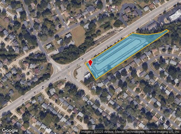
940 Shackelford Rd, Florissant, MO 63031

NEARBY LISTINGS FOR SALE OR LEASE
-
-
View all Florissant listings for sale on LoopNet.com
Property Detail
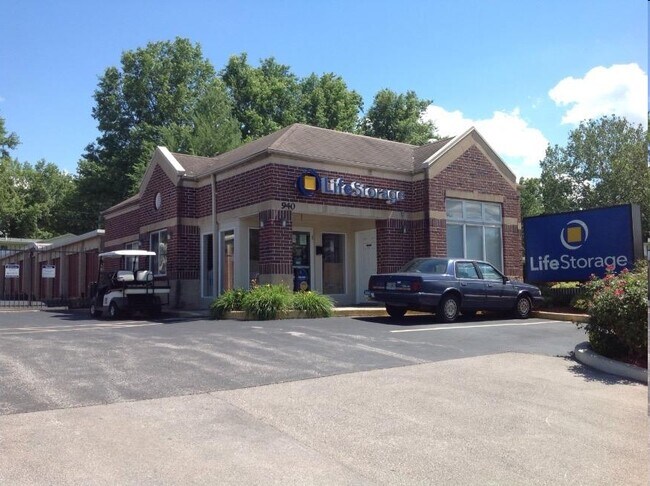
940 Shackelford Rd
St. Louis, MO-IL
Shackelford Mini-Storage
07K-53-1163
SHACKELFORD MINI-STORAGE LOT 1
Warehouse
St. Louis
AE
Missouri
29183C0325G
1
2024
3.24 AC
2025
North County
211301
St. Louis
49,736 SF
DEMOGRAPHICS near 940 Shackelford Rd
1 Mile
3 Mile
5 Mile
2024 Total Population
15,331
74,134
125,843
2029 Population
14,944
72,467
123,394
Pop Growth 2024-2029
(2.52%)
(2.25%)
(1.95%)
Average Age
39
39
40
2024 Total Households
6,068
29,724
50,404
HH Growth 2024-2029
(2.60%)
(2.29%)
(2.00%)
Median Household Inc
$61,209
$61,640
$60,430
Avg Household Size
2.40
2.40
2.40
2024 Avg HH Vehicles
2.00
2.00
2.00
Median Home Value
$137,605
$147,787
$149,500
Median Year Built
1965
1966
1966
Nearby Places
Map Layers
Map Styles
 Street
 Aerial
- Restaurants
- Banks
- Shops
- Fitness
- Groceries
PUBLIC TRANSPORTATION
COMMUTER RAIL
Lambert Airport East Terminal (Lambert Airport Shiloh-Scott - St. Louis MetroLink (MetroLink))
DRIVE
WALK
Distance
Lambert Airport East Terminal (Lambert Airport Shiloh-Scott - St. Louis MetroLink (MetroLink))
14 min
8.1 mi
Lambert Airport Main Terminal (Lambert Airport Shiloh-Scott - St. Louis MetroLink (MetroLink))
DRIVE
WALK
Distance
Lambert Airport Main Terminal (Lambert Airport Shiloh-Scott - St. Louis MetroLink (MetroLink))
16 min
8.6 mi
AIRPORT
St Louis Lambert International
DRIVE
WALK
Distance
St Louis Lambert International
13 min
7.0 mi
Freight Ports
Port Milwaukee
DRIVE
WALK
Distance
Port Milwaukee
431 min
377.2 mi
Nearby Properties
Address
Land Use
TOTAL SIZE
Lot Size
Zoning
Address
Land Use
TOTAL SIZE
Lot Size
Zoning
47,184 SF
71.66 AC
R4
Address
Land Use
TOTAL SIZE
Lot Size
Zoning
4,416 SF
54.81 AC
80B
Address
Land Use
TOTAL SIZE
Lot Size
Zoning
71.29 AC
24R4
Address
Land Use
TOTAL SIZE
Lot Size
Zoning
296,795 SF
286.21 AC
C-8
Address
Land Use
TOTAL SIZE
Lot Size
Zoning
15.37 AC
R
Address
Land Use
TOTAL SIZE
Lot Size
Zoning
271,184 SF
13.67 AC
B3
Address
Land Use
TOTAL SIZE
Lot Size
Zoning
335,294 SF
33.83 AC
24MFD
Address
Land Use
TOTAL SIZE
Lot Size
Zoning
6.88 AC
H
Address
Land Use
TOTAL SIZE
Lot Size
Zoning
293,622 SF
28.06 AC
H
Address
Land Use
TOTAL SIZE
Lot Size
Zoning
354,790 SF
22.46 AC
B6
Address
Land Use
TOTAL SIZE
Lot Size
Zoning
262,938 SF
11.32 AC
80H
Address
Land Use
TOTAL SIZE
Lot Size
Zoning
269,258 SF
89.80 AC
80F
Address
Land Use
TOTAL SIZE
Lot Size
Zoning
21.29 AC
24R4
Address
Land Use
TOTAL SIZE
Lot Size
Zoning
320,176 SF
9.83 AC
24MFD
Address
Land Use
TOTAL SIZE
Lot Size
Zoning
387,158 SF
34.19 AC
R6
Address
Land Use
TOTAL SIZE
Lot Size
Zoning
203,240 SF
8.50 AC
80H
Address
Land Use
TOTAL SIZE
Lot Size
Zoning
1,560 SF
12.84 AC
R4
Address
Land Use
TOTAL SIZE
Lot Size
Zoning
999 SF
21.20 AC
R
Address
Land Use
TOTAL SIZE
Lot Size
Zoning
305,740 SF
15.77 AC
7M-1
Address
Land Use
TOTAL SIZE
Lot Size
Zoning
78,460 SF
4.13 AC
G
Address
Land Use
TOTAL SIZE
Lot Size
Zoning
11.27 AC
24R4
Address
Land Use
TOTAL SIZE
Lot Size
Zoning
17.26 AC
24R4
Address
Land Use
TOTAL SIZE
Lot Size
Zoning
6.20 AC
24R4
Address
Land Use
TOTAL SIZE
Lot Size
Zoning
181,890 SF
27.54 AC
7M-1
Address
Land Use
TOTAL SIZE
Lot Size
Zoning
218,932 SF
13.77 AC
R6
Address
Land Use
TOTAL SIZE
Lot Size
Zoning
134,837 SF
11.43 AC
R4
Address
Land Use
TOTAL SIZE
Lot Size
Zoning
227,500 SF
13.62 AC
80I
Address
Land Use
TOTAL SIZE
Lot Size
Zoning
85,971 SF
5.63 AC
24R4
Address
Land Use
TOTAL SIZE
Lot Size
Zoning
244,836 SF
7 AC
80H
Address
Land Use
TOTAL SIZE
Lot Size
Zoning
90,796 SF
8.62 AC
B3
The World's #1 Commercial Real Estate Marketplace
Connect with us
© 2025 CoStar Group
The information above has been obtained from sources believed reliable. While we do not doubt its accuracy we have not verified it and make no guarantee, warranty or representation about it. It is your responsibility to independently confirm its accuracy and completeness. Any projections, opinions, assumptions, or estimates used are for example only and do not represent the current or future performance of the property. The value of this transaction to you depends on tax and other factors which should be evaluated by your tax, financial, and legal advisors. You and your advisors should conduct a careful, independent investigation of the property to determine to your satisfaction the suitability of the property for your needs.