Property Record
4012 Montana Sapphire Dr, Billings, MT 59106
NEARBY LISTINGS FOR SALE OR LEASE
Property Detail
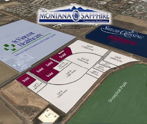
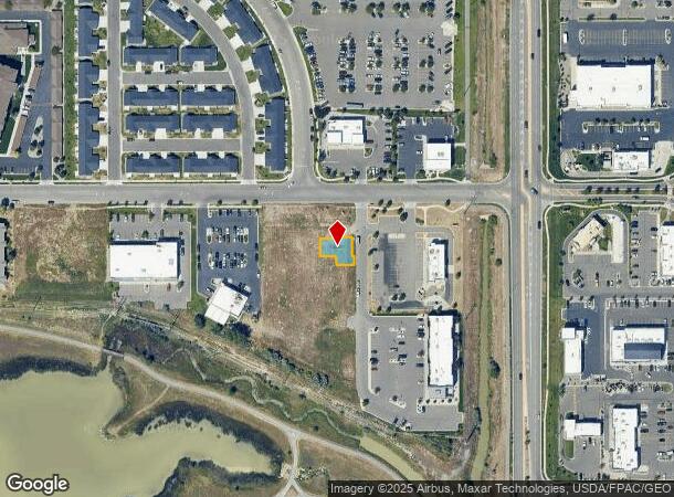
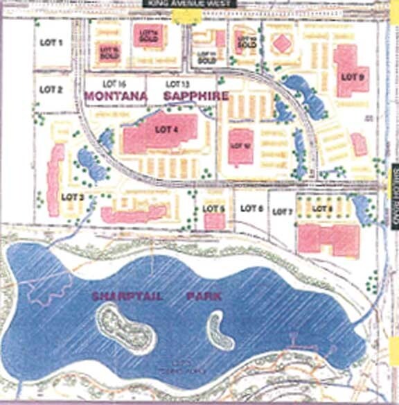
4012 Montana Sapphire Dr
Billings, MT
4016 Office Park (25)
03-0926-15-1-80-35-0000
4016 OFFICE PARK (25), S15, T01 S, R25 E, UNIT A, 20% COMMON AREA INTEREST, LOC @ LT 8A, BLK 1, MONTANA SAPPHIRE SUB AMD
Commercialacreage
Yellowstone
X
Montana
30111C1265E
8a
2024
0.10 AC
2025
Billings
001404
Other Market Areas
DEMOGRAPHICS near 4012 Montana Sapphire Dr
1 Mile
3 Mile
5 Mile
2024 Total Population
8,014
35,512
87,485
2029 Population
8,753
38,730
95,016
Pop Growth 2024-2029
+ 9.22%
+ 9.06%
+ 8.61%
Average Age
39
42
41
2024 Total Households
3,688
15,557
37,134
HH Growth 2024-2029
+ 9.41%
+ 9.29%
+ 8.79%
Median Household Inc
$67,255
$71,748
$74,235
Avg Household Size
2.10
2.20
2.30
2024 Avg HH Vehicles
2.00
2.00
2.00
Median Home Value
$258,576
$294,971
$315,321
Median Year Built
1996
1994
1983
Nearby Places
Map Layers
Map Styles
 Street
 Aerial
- Restaurants
- Banks
- Shops
- Fitness
- Groceries
PUBLIC TRANSPORTATION
AIRPORT
Billings Logan International
DRIVE
WALK
Distance
Billings Logan International
25 min
9.4 mi
Freight Ports
Port of Everett
DRIVE
WALK
Distance
Port of Everett
879 min
837.2 mi
SALE & LEASE HISTORY
LISTING DATE
SALE/LEASE

Oct 17, 2016
For Sale
Nearby Properties
Address
Land Use
TOTAL SIZE
Lot Size
Zoning
Address
Land Use
TOTAL SIZE
Lot Size
Zoning
145.51 AC
Address
Land Use
TOTAL SIZE
Lot Size
Zoning
343,075 SF
0.56 AC
Address
Land Use
TOTAL SIZE
Lot Size
Zoning
164,242 SF
33.08 AC
P
Address
Land Use
TOTAL SIZE
Lot Size
Zoning
35.04 AC
Address
Land Use
TOTAL SIZE
Lot Size
Zoning
167,261 SF
10.55 AC
R-150
Address
Land Use
TOTAL SIZE
Lot Size
Zoning
136,588 SF
21.01 AC
CI
Address
Land Use
TOTAL SIZE
Lot Size
Zoning
32,460 SF
10.88 AC
A-1
Address
Land Use
TOTAL SIZE
Lot Size
Zoning
188,030 SF
13.88 AC
A-1
Address
Land Use
TOTAL SIZE
Lot Size
Zoning
259,684 SF
14.73 AC
Address
Land Use
TOTAL SIZE
Lot Size
Zoning
173,042 SF
10.27 AC
Address
Land Use
TOTAL SIZE
Lot Size
Zoning
116,250 SF
9.39 AC
Address
Land Use
TOTAL SIZE
Lot Size
Zoning
138,502 SF
18.97 AC
Address
Land Use
TOTAL SIZE
Lot Size
Zoning
156,883 SF
12.86 AC
Address
Land Use
TOTAL SIZE
Lot Size
Zoning
70,034 SF
7.29 AC
Address
Land Use
TOTAL SIZE
Lot Size
Zoning
77.63 AC
Address
Land Use
TOTAL SIZE
Lot Size
Zoning
537,468 SF
36.83 AC
CC
Address
Land Use
TOTAL SIZE
Lot Size
Zoning
173,807 SF
11.56 AC
CI
Address
Land Use
TOTAL SIZE
Lot Size
Zoning
156.04 AC
Address
Land Use
TOTAL SIZE
Lot Size
Zoning
16,656 SF
10.85 AC
Address
Land Use
TOTAL SIZE
Lot Size
Zoning
218,478 SF
18.19 AC
CI
Address
Land Use
TOTAL SIZE
Lot Size
Zoning
109,467 SF
5.97 AC
Address
Land Use
TOTAL SIZE
Lot Size
Zoning
13,216 SF
144.80 AC
A-1
Address
Land Use
TOTAL SIZE
Lot Size
Zoning
177,290 SF
14.59 AC
HC
Address
Land Use
TOTAL SIZE
Lot Size
Zoning
151,056 SF
49.20 AC
A-1
Address
Land Use
TOTAL SIZE
Lot Size
Zoning
42,186 SF
13.43 AC
Address
Land Use
TOTAL SIZE
Lot Size
Zoning
168,560 SF
24.67 AC
Address
Land Use
TOTAL SIZE
Lot Size
Zoning
67.17 AC
Address
Land Use
TOTAL SIZE
Lot Size
Zoning
109,485 SF
8.87 AC
R-96
Address
Land Use
TOTAL SIZE
Lot Size
Zoning
167,744 SF
16.45 AC
CI
Address
Land Use
TOTAL SIZE
Lot Size
Zoning
7,538 SF
59.81 AC
A-1
The World's #1 Commercial Real Estate Marketplace
Connect with us
© 2025 CoStar Group
The information above has been obtained from sources believed reliable. While we do not doubt its accuracy we have not verified it and make no guarantee, warranty or representation about it. It is your responsibility to independently confirm its accuracy and completeness. Any projections, opinions, assumptions, or estimates used are for example only and do not represent the current or future performance of the property. The value of this transaction to you depends on tax and other factors which should be evaluated by your tax, financial, and legal advisors. You and your advisors should conduct a careful, independent investigation of the property to determine to your satisfaction the suitability of the property for your needs.