Property Record
9400 E Mcnelly Rd, Bentonville, AR 72712
Save to a Folder
{{folder.Name}}
{{folder.ListingIds.length}} Properties
{{folder.ListingIds.length}} Property
Create a New Folder
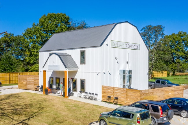
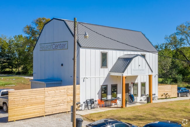
Property Detail
9400 E Mcnelly Rd
18-08019-007
SURVEYS: 7/06/2016 2016-507 A PART OF THE SOUTHEAST QUARTER OF THE NORTHEAST QUARTER AND A PART OF THE NORTHEAST QUARTER OF THE SOUTHEAST QUARTER, ALL IN SECTION 33, TOWNSHIP 21 NORTH, RANGE 30 WEST, BENTON COUNTY, ARKANSAS, BEING MORE PARTICULARLY D
Officebuilding
Benton
B and X Area of moderate flood hazard, usually the area between the limits of the 100-year and 500-year floods.
Arkansas
2025
2.04 AC
2025
Outlying Benton County
020103
Fayetteville/Springdale/Rogers
11,738 SF
Fayetteville-Springdale-Rogers, AR
NEARBY LISTINGS FOR SALE OR LEASE
DEMOGRAPHICS near 9400 E Mcnelly Rd
1 mile
3 mile
5 mile
2025 Total Population
1,075
16,237
41,331
2030 Population
1,193
18,238
45,966
Pop Growth 2025-2030
+ 10.98%
+ 12.32%
+ 11.21%
Average Age
43
41
40
2025 Total Households
416
6,028
15,641
HH Growth 2025-2030
+ 11.30%
+ 12.48%
+ 11.41%
Median Household Inc
$101,862
$102,691
$104,365
Avg Household Size
2.50
2.70
2.60
2025 Avg HH Vehicles
2.00
2.00
2.00
Median Home Value
$340,123
$350,504
$374,920
Median Year Built
1999
2000
1998
Nearby Places
Map Layers
Map Styles
 Street
 Aerial
Layers
 Traffic
 Biking
Places
Listings with unknown addresses are not visible on the map
- Restaurants
- Banks
- Shops
- Fitness
- Groceries
PUBLIC TRANSPORTATION
AIRPORT
Northwest Arkansas Ntl
Drive
Walk
Distance
Northwest Arkansas Ntl
37 min
18.9 mi
Nearby Properties
Address
Land Use
TOTAL SIZE
Lot Size
Zoning
Address
Land Use
TOTAL SIZE
Lot Size
Zoning
7,650 SF
5.63 AC
Address
Land Use
TOTAL SIZE
Lot Size
Zoning
146,778 SF
10.32 AC
Address
Land Use
TOTAL SIZE
Lot Size
Zoning
5,936 SF
1.03 AC
Address
Land Use
TOTAL SIZE
Lot Size
Zoning
106,920 SF
6.85 AC
Address
Land Use
TOTAL SIZE
Lot Size
Zoning
9,268 SF
3.80 AC
Address
Land Use
TOTAL SIZE
Lot Size
Zoning
60,356 SF
3.48 AC
Address
Land Use
TOTAL SIZE
Lot Size
Zoning
3,960 SF
1.13 AC
Address
Land Use
TOTAL SIZE
Lot Size
Zoning
13,056 SF
2.41 AC
Address
Land Use
TOTAL SIZE
Lot Size
Zoning
6,811 SF
0.95 AC
Address
Land Use
TOTAL SIZE
Lot Size
Zoning
10,920 SF
0.89 AC
Address
Land Use
TOTAL SIZE
Lot Size
Zoning
7,862 SF
91.40 AC
Address
Land Use
TOTAL SIZE
Lot Size
Zoning
11,200 SF
1.16 AC
Address
Land Use
TOTAL SIZE
Lot Size
Zoning
4,300 SF
Address
Land Use
TOTAL SIZE
Lot Size
Zoning
2,290 SF
0.95 AC
Address
Land Use
TOTAL SIZE
Lot Size
Zoning
771 SF
56.72 AC
Address
Land Use
TOTAL SIZE
Lot Size
Zoning
3,120 SF
1.40 AC
Address
Land Use
TOTAL SIZE
Lot Size
Zoning
10,716 SF
1.63 AC
Address
Land Use
TOTAL SIZE
Lot Size
Zoning
21,312 SF
2.01 AC
Address
Land Use
TOTAL SIZE
Lot Size
Zoning
11,735 SF
6 AC
Address
Land Use
TOTAL SIZE
Lot Size
Zoning
1,728 SF
0.02 AC
Address
Land Use
TOTAL SIZE
Lot Size
Zoning
4,800 SF
5.79 AC
Address
Land Use
TOTAL SIZE
Lot Size
Zoning
7,500 SF
5 AC
Address
Land Use
TOTAL SIZE
Lot Size
Zoning
320 SF
7.76 AC
Address
Land Use
TOTAL SIZE
Lot Size
Zoning
1,440 SF
59.65 AC
Address
Land Use
TOTAL SIZE
Lot Size
Zoning
4,400 SF
0.48 AC
Address
Land Use
TOTAL SIZE
Lot Size
Zoning
9,300 SF
5.51 AC
Address
Land Use
TOTAL SIZE
Lot Size
Zoning
2,100 SF
32.76 AC
Address
Land Use
TOTAL SIZE
Lot Size
Zoning
1,656 SF
2.22 AC
Address
Land Use
TOTAL SIZE
Lot Size
Zoning
6,508 SF
0.47 AC
The World's #1 Commercial Real Estate Marketplace
Connect with us
© 2026 CoStar Group
The information above has been obtained from sources believed reliable. While we do not doubt its accuracy we have not verified it and make no guarantee, warranty or representation about it. It is your responsibility to independently confirm its accuracy and completeness. Any projections, opinions, assumptions, or estimates used are for example only and do not represent the current or future performance of the property. The value of this transaction to you depends on tax and other factors which should be evaluated by your tax, financial, and legal advisors. You and your advisors should conduct a careful, independent investigation of the property to determine to your satisfaction the suitability of the property for your needs.