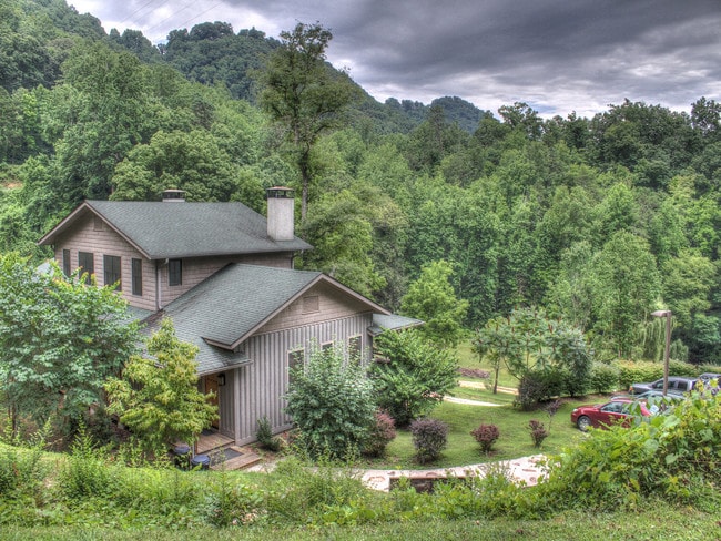
Property Record
9400 Highway 19 W, Bryson City, NC 28713
NEARBY LISTINGS FOR SALE OR LEASE
-
-
View all Bryson City listings for lease on LoopNet.com
Property Detail
9400 Highway 19 W
6641-00-25-5850
Nantahala Village South
Hotelormotel
30-NB-4440-AB-NANT VILLAGE INN
X
Swain
3700664100J
North Carolina
2025
19
2025
60.88 AC
960301
North Carolina West/Cherokee Area
19,306 SF
Other Market Areas
DEMOGRAPHICS near 9400 Highway 19 W
1 Mile
3 Mile
5 Mile
2024 Total Population
132
986
2,940
2029 Population
137
1,023
3,039
Pop Growth 2024-2029
+ 3.79%
+ 3.75%
+ 3.37%
Average Age
47
46
46
2024 Total Households
55
413
1,254
HH Growth 2024-2029
+ 3.64%
+ 3.63%
+ 3.19%
Median Household Inc
$42,000
$42,758
$52,500
Avg Household Size
2.30
2.30
2.30
2024 Avg HH Vehicles
2.00
2.00
2.00
Median Home Value
$225,000
$226,389
$212,348
Median Year Built
1987
1988
1991
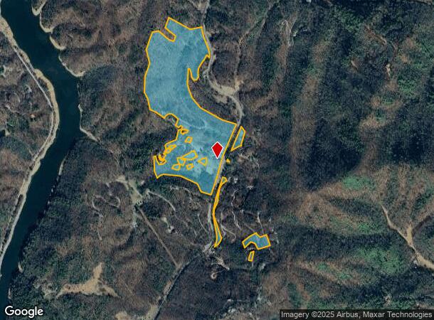
Nearby Places
Map Layers
Map Styles
 Street
 Aerial
- Restaurants
- Banks
- Shops
- Fitness
- Groceries
SALE & LEASE HISTORY
LISTING DATE
SALE/LEASE

May 13, 2022
For Lease
May 13, 2022
For Lease
Jan 19, 2018
For Lease
Jan 10, 2019
For Sale
Aug 02, 2019
For Sale
Nearby Properties
Address
Land Use
TOTAL SIZE
Lot Size
Zoning
Address
Land Use
TOTAL SIZE
Lot Size
Zoning
9,346 SF
423.14 AC
Address
Land Use
TOTAL SIZE
Lot Size
Zoning
865.52 AC
Address
Land Use
TOTAL SIZE
Lot Size
Zoning
22,991 SF
4.79 AC
Address
Land Use
TOTAL SIZE
Lot Size
Zoning
139.48 AC
Address
Land Use
TOTAL SIZE
Lot Size
Zoning
3,465 SF
42.16 AC
Address
Land Use
TOTAL SIZE
Lot Size
Zoning
195.52 AC
Address
Land Use
TOTAL SIZE
Lot Size
Zoning
4,269 SF
30.12 AC
Address
Land Use
TOTAL SIZE
Lot Size
Zoning
0.68 AC
Address
Land Use
TOTAL SIZE
Lot Size
Zoning
Address
Land Use
TOTAL SIZE
Lot Size
Zoning
34.22 AC
Address
Land Use
TOTAL SIZE
Lot Size
Zoning
3,979.80 AC
Address
Land Use
TOTAL SIZE
Lot Size
Zoning
113.36 AC
Address
Land Use
TOTAL SIZE
Lot Size
Zoning
Address
Land Use
TOTAL SIZE
Lot Size
Zoning
3,400 SF
7.64 AC
Address
Land Use
TOTAL SIZE
Lot Size
Zoning
3,342 SF
21.77 AC
Address
Land Use
TOTAL SIZE
Lot Size
Zoning
3.24 AC
Address
Land Use
TOTAL SIZE
Lot Size
Zoning
214.40 AC
Address
Land Use
TOTAL SIZE
Lot Size
Zoning
2,784 SF
9.07 AC
Address
Land Use
TOTAL SIZE
Lot Size
Zoning
3,840 SF
6.76 AC
Address
Land Use
TOTAL SIZE
Lot Size
Zoning
20.71 AC
Address
Land Use
TOTAL SIZE
Lot Size
Zoning
41.13 AC
Address
Land Use
TOTAL SIZE
Lot Size
Zoning
12.31 AC
Address
Land Use
TOTAL SIZE
Lot Size
Zoning
71.08 AC
Address
Land Use
TOTAL SIZE
Lot Size
Zoning
83.45 AC
Address
Land Use
TOTAL SIZE
Lot Size
Zoning
22.48 AC
Address
Land Use
TOTAL SIZE
Lot Size
Zoning
Address
Land Use
TOTAL SIZE
Lot Size
Zoning
2.68 AC
Address
Land Use
TOTAL SIZE
Lot Size
Zoning
Address
Land Use
TOTAL SIZE
Lot Size
Zoning
2.01 AC
The World's #1 Commercial Real Estate Marketplace
Connect with us
© 2026 CoStar Group
The information above has been obtained from sources believed reliable. While we do not doubt its accuracy we have not verified it and make no guarantee, warranty or representation about it. It is your responsibility to independently confirm its accuracy and completeness. Any projections, opinions, assumptions, or estimates used are for example only and do not represent the current or future performance of the property. The value of this transaction to you depends on tax and other factors which should be evaluated by your tax, financial, and legal advisors. You and your advisors should conduct a careful, independent investigation of the property to determine to your satisfaction the suitability of the property for your needs.