Property Record
9400 Livingston Rd, Fort Washington, MD 20744

NEARBY LISTINGS FOR SALE OR LEASE
Property Detail
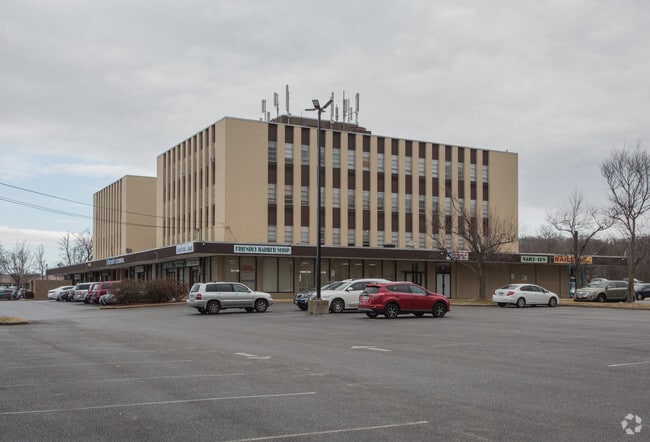
9400 Livingston Rd
12-1241587
South Potomac Professional Cen
Officebuilding
PARCEL A
AE
Prince George's
24033C0240E
Maryland
2024
2.26 AC
2025
NatHbr/OxnHill/FtWash
801411
Washington, DC
63,344 SF
Washington-Arlington-Alexandria, DC-VA-MD-WV
DEMOGRAPHICS near 9400 Livingston Rd
1 Mile
3 Mile
5 Mile
2024 Total Population
6,477
46,642
212,850
2029 Population
6,310
45,503
207,232
Pop Growth 2024-2029
(2.58%)
(2.44%)
(2.64%)
Average Age
43
44
41
2024 Total Households
2,600
17,244
87,109
HH Growth 2024-2029
(2.69%)
(2.50%)
(2.71%)
Median Household Inc
$98,962
$112,937
$101,529
Avg Household Size
2.40
2.60
2.40
2024 Avg HH Vehicles
2.00
2.00
2.00
Median Home Value
$363,856
$408,131
$446,966
Median Year Built
1981
1978
1974
Nearby Places
Map Layers
Map Styles
 Street
 Aerial
- Restaurants
- Banks
- Shops
- Fitness
- Groceries
PUBLIC TRANSPORTATION
COMMUTER RAIL
DRIVE
WALK
Distance
15 min
7.5 mi
Alexandria (Fredericksburg Line - Virginia Railway Express, Manassas Line - Virginia Railway Express)
DRIVE
WALK
Distance
Alexandria (Fredericksburg Line - Virginia Railway Express, Manassas Line - Virginia Railway Express)
15 min
7.6 mi
AIRPORT
Ronald Reagan Washington Ntl
DRIVE
WALK
Distance
Ronald Reagan Washington Ntl
25 min
11.3 mi
Washington Dulles International
DRIVE
WALK
Distance
Washington Dulles International
59 min
38.0 mi
Baltimore/Washington International Thurgood Marshall
DRIVE
WALK
Distance
Baltimore/Washington International Thurgood Marshall
61 min
38.9 mi
Freight Ports
Port of Baltimore
DRIVE
WALK
Distance
Port of Baltimore
70 min
45.2 mi
SALE & LEASE HISTORY
LISTING DATE
SALE/LEASE

Sep 24, 2016
For Lease
Nearby Properties
Address
Land Use
TOTAL SIZE
Lot Size
Zoning
Address
Land Use
TOTAL SIZE
Lot Size
Zoning
1,241,298 SF
11.53 AC
RTOLE
Address
Land Use
TOTAL SIZE
Lot Size
Zoning
2,308,874 SF
22.78 AC
RR
Address
Land Use
TOTAL SIZE
Lot Size
Zoning
1,931,127 SF
11.53 AC
RTOLE
Address
Land Use
TOTAL SIZE
Lot Size
Zoning
373,996 SF
37.74 AC
IE
Address
Land Use
TOTAL SIZE
Lot Size
Zoning
587,628 SF
3.18 AC
RTOLC
Address
Land Use
TOTAL SIZE
Lot Size
Zoning
380 SF
17.44 AC
RMF20
Address
Land Use
TOTAL SIZE
Lot Size
Zoning
500,595 SF
18.90 AC
RR
Address
Land Use
TOTAL SIZE
Lot Size
Zoning
235,000 SF
23.52 AC
ROS
Address
Land Use
TOTAL SIZE
Lot Size
Zoning
126,588 SF
0.71 AC
RTOLC
Address
Land Use
TOTAL SIZE
Lot Size
Zoning
165,240 SF
1.07 AC
RTOLC
Address
Land Use
TOTAL SIZE
Lot Size
Zoning
120,946 SF
0.50 AC
RTOLC
Address
Land Use
TOTAL SIZE
Lot Size
Zoning
96,015 SF
0.87 AC
RTOLC
Address
Land Use
TOTAL SIZE
Lot Size
Zoning
127,484 SF
0.51 AC
RTOLC
Address
Land Use
TOTAL SIZE
Lot Size
Zoning
116 SF
10.37 AC
RMF20
Address
Land Use
TOTAL SIZE
Lot Size
Zoning
152,340 SF
0.49 AC
MXT
Address
Land Use
TOTAL SIZE
Lot Size
Zoning
419,783 SF
1.98 AC
MXT
Address
Land Use
TOTAL SIZE
Lot Size
Zoning
96,250 SF
0.90 AC
RTOLC
Address
Land Use
TOTAL SIZE
Lot Size
Zoning
300,005 SF
9.94 AC
RR
Address
Land Use
TOTAL SIZE
Lot Size
Zoning
539,448 SF
2.14 AC
MXT
Address
Land Use
TOTAL SIZE
Lot Size
Zoning
529,667 SF
2.10 AC
MXT
Address
Land Use
TOTAL SIZE
Lot Size
Zoning
11.65 AC
RMF20
Address
Land Use
TOTAL SIZE
Lot Size
Zoning
434,910 SF
0.46 AC
RR
Address
Land Use
TOTAL SIZE
Lot Size
Zoning
8.02 AC
RMF20
Address
Land Use
TOTAL SIZE
Lot Size
Zoning
15,393 SF
27.58 AC
120
Address
Land Use
TOTAL SIZE
Lot Size
Zoning
7 AC
RMF20
Address
Land Use
TOTAL SIZE
Lot Size
Zoning
1,217 SF
8.94 AC
RMF20
Address
Land Use
TOTAL SIZE
Lot Size
Zoning
72,100 SF
11.36 AC
NAC
Address
Land Use
TOTAL SIZE
Lot Size
Zoning
82,204 SF
0.38 AC
MXT
Address
Land Use
TOTAL SIZE
Lot Size
Zoning
89,089 SF
4.78 AC
CGO
Address
Land Use
TOTAL SIZE
Lot Size
Zoning
21.63 AC
RTOLE
The World's #1 Commercial Real Estate Marketplace
Connect with us
© 2026 CoStar Group
The information above has been obtained from sources believed reliable. While we do not doubt its accuracy we have not verified it and make no guarantee, warranty or representation about it. It is your responsibility to independently confirm its accuracy and completeness. Any projections, opinions, assumptions, or estimates used are for example only and do not represent the current or future performance of the property. The value of this transaction to you depends on tax and other factors which should be evaluated by your tax, financial, and legal advisors. You and your advisors should conduct a careful, independent investigation of the property to determine to your satisfaction the suitability of the property for your needs.