Property Record
9400 N Sam Houston Pkwy E, Humble, TX 77396


NEARBY LISTINGS FOR SALE OR LEASE
Property Detail
9400 N Sam Houston Pkwy E
1274820010001
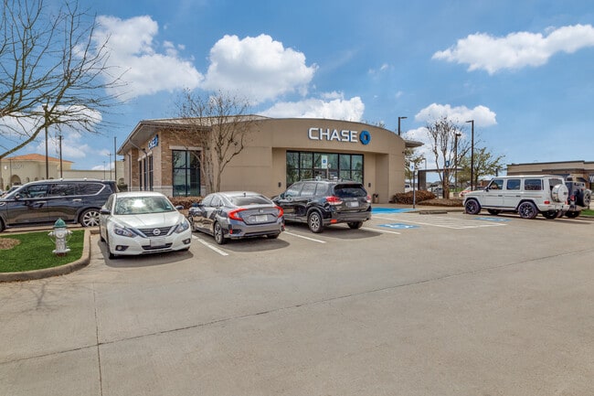
Chase Bank At Wilson Road
Financialbuilding
RES A BLK 1 CHASE BANK AT WILSON ROAD
X
Harris
48201C0495L
Texas
2024
0.90 AC
2025
Near Northeast
232203
Houston
4,192 SF
Houston-The Woodlands-Sugar Land, TX
DEMOGRAPHICS near 9400 N Sam Houston Pkwy E
1 Mile
3 Mile
5 Mile
2024 Total Population
13,096
54,559
151,210
2029 Population
13,429
56,595
155,694
Pop Growth 2024-2029
+ 2.54%
+ 3.73%
+ 2.97%
Average Age
34
33
34
2024 Total Households
4,779
17,547
48,229
HH Growth 2024-2029
+ 2.66%
+ 3.68%
+ 2.93%
Median Household Inc
$74,956
$74,413
$70,279
Avg Household Size
2.70
3.10
3.10
2024 Avg HH Vehicles
2.00
2.00
2.00
Median Home Value
$288,811
$241,307
$230,588
Median Year Built
2007
2006
2002
Nearby Places
Map Layers
Map Styles
 Street
 Aerial
- Restaurants
- Banks
- Shops
- Fitness
- Groceries
PUBLIC TRANSPORTATION
AIRPORT
George Bush Intcntl/Houston
DRIVE
WALK
Distance
George Bush Intcntl/Houston
11 min
8.1 mi
William P Hobby
DRIVE
WALK
Distance
William P Hobby
44 min
28.3 mi
Freight Ports
Port of Houston
DRIVE
WALK
Distance
Port of Houston
31 min
20.4 mi
SALE & LEASE HISTORY
LISTING DATE
SALE/LEASE

Apr 27, 2018
For Sale
Apr 06, 2021
For Sale
Nearby Properties
Address
Land Use
TOTAL SIZE
Lot Size
Zoning
Address
Land Use
TOTAL SIZE
Lot Size
Zoning
1,290,468 SF
Address
Land Use
TOTAL SIZE
Lot Size
Zoning
1,036,748 SF
72.42 AC
Address
Land Use
TOTAL SIZE
Lot Size
Zoning
642,163 SF
37.07 AC
Address
Land Use
TOTAL SIZE
Lot Size
Zoning
309,159 SF
30.87 AC
Address
Land Use
TOTAL SIZE
Lot Size
Zoning
324,170 SF
10.32 AC
Address
Land Use
TOTAL SIZE
Lot Size
Zoning
514,500 SF
40.85 AC
Address
Land Use
TOTAL SIZE
Lot Size
Zoning
306,652 SF
10.67 AC
Address
Land Use
TOTAL SIZE
Lot Size
Zoning
306,765 SF
20.19 AC
Address
Land Use
TOTAL SIZE
Lot Size
Zoning
320,798 SF
14.25 AC
Address
Land Use
TOTAL SIZE
Lot Size
Zoning
382,632 SF
22.14 AC
Address
Land Use
TOTAL SIZE
Lot Size
Zoning
256,181 SF
11.44 AC
Address
Land Use
TOTAL SIZE
Lot Size
Zoning
260,427 SF
4.50 AC
Address
Land Use
TOTAL SIZE
Lot Size
Zoning
73,500 SF
115.96 AC
Address
Land Use
TOTAL SIZE
Lot Size
Zoning
449,858 SF
22.20 AC
Address
Land Use
TOTAL SIZE
Lot Size
Zoning
301,200 SF
27.48 AC
Address
Land Use
TOTAL SIZE
Lot Size
Zoning
321,604 SF
16.68 AC
Address
Land Use
TOTAL SIZE
Lot Size
Zoning
246,712 SF
13.33 AC
Address
Land Use
TOTAL SIZE
Lot Size
Zoning
276,464 SF
18.79 AC
Address
Land Use
TOTAL SIZE
Lot Size
Zoning
315,434 SF
13.16 AC
Address
Land Use
TOTAL SIZE
Lot Size
Zoning
247,045 SF
Address
Land Use
TOTAL SIZE
Lot Size
Zoning
219,483 SF
95.68 AC
Address
Land Use
TOTAL SIZE
Lot Size
Zoning
230,877 SF
12.02 AC
Address
Land Use
TOTAL SIZE
Lot Size
Zoning
398,984 SF
80.43 AC
Address
Land Use
TOTAL SIZE
Lot Size
Zoning
262,010 SF
12.64 AC
Address
Land Use
TOTAL SIZE
Lot Size
Zoning
254,832 SF
12.65 AC
Address
Land Use
TOTAL SIZE
Lot Size
Zoning
264,945 SF
11.74 AC
Address
Land Use
TOTAL SIZE
Lot Size
Zoning
260,630 SF
15.16 AC
Address
Land Use
TOTAL SIZE
Lot Size
Zoning
259,500 SF
12.28 AC
Address
Land Use
TOTAL SIZE
Lot Size
Zoning
149,623 SF
5.62 AC
Address
Land Use
TOTAL SIZE
Lot Size
Zoning
117,038 SF
12.77 AC
The World's #1 Commercial Real Estate Marketplace
Connect with us
© 2026 CoStar Group
The information above has been obtained from sources believed reliable. While we do not doubt its accuracy we have not verified it and make no guarantee, warranty or representation about it. It is your responsibility to independently confirm its accuracy and completeness. Any projections, opinions, assumptions, or estimates used are for example only and do not represent the current or future performance of the property. The value of this transaction to you depends on tax and other factors which should be evaluated by your tax, financial, and legal advisors. You and your advisors should conduct a careful, independent investigation of the property to determine to your satisfaction the suitability of the property for your needs.