Property Record
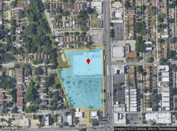
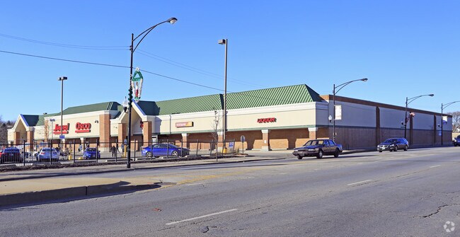
9400 S Ashland Ave, Chicago, IL 60620

NEARBY LISTINGS FOR SALE OR LEASE
Property Detail
9400 S Ashland Ave
25-06-426-015-0000
Jewel 3176 Resub
Supermarket
Cook
X
Illinois
17031C0635J
1
2023
5.47 AC
2025
South Chicago
730300
Chicago
66,152 SF
Chicago-Naperville-Elgin, IL-IN
DEMOGRAPHICS near 9400 S Ashland Ave
1 Mile
3 Mile
5 Mile
2024 Total Population
24,316
215,141
581,727
2029 Population
23,413
207,841
560,683
Pop Growth 2024-2029
(3.71%)
(3.39%)
(3.62%)
Average Age
43
41
40
2024 Total Households
9,303
80,629
215,872
HH Growth 2024-2029
(4.14%)
(3.81%)
(3.92%)
Median Household Inc
$72,411
$58,490
$50,029
Avg Household Size
2.50
2.60
2.60
2024 Avg HH Vehicles
1.00
1.00
1.00
Median Home Value
$254,264
$196,050
$190,161
Median Year Built
1947
1950
1952
Nearby Places
Map Layers
Map Styles
 Street
 Aerial
- Restaurants
- Banks
- Shops
- Fitness
- Groceries
PUBLIC TRANSPORTATION
TRANSIT/SUBWAY
Beverly-91st Street Station (Rock Island District Line - Northeast Illinois Regional Commuter Railroad (Metra))
DRIVE
WALK
Distance
Beverly-91st Street Station (Rock Island District Line - Northeast Illinois Regional Commuter Railroad (Metra))
5 min
8 min
0.4 mi
95th Street Station (Rock Island District Line - Northeast Illinois Regional Commuter Railroad (Metra))
DRIVE
WALK
Distance
95th Street Station (Rock Island District Line - Northeast Illinois Regional Commuter Railroad (Metra))
1 min
9 min
0.5 mi
Brainerd Station (Rock Island District Line - Northeast Illinois Regional Commuter Railroad (Metra))
DRIVE
WALK
Distance
Brainerd Station (Rock Island District Line - Northeast Illinois Regional Commuter Railroad (Metra))
3 min
17 min
0.9 mi
Longwood Station (Rock Island District Line - Northeast Illinois Regional Commuter Railroad (Metra))
DRIVE
WALK
Distance
Longwood Station (Rock Island District Line - Northeast Illinois Regional Commuter Railroad (Metra))
2 min
18 min
0.9 mi
99th Street Station (Rock Island District Line - Northeast Illinois Regional Commuter Railroad (Metra))
DRIVE
WALK
Distance
99th Street Station (Rock Island District Line - Northeast Illinois Regional Commuter Railroad (Metra))
4 min
19 min
1.0 mi
COMMUTER RAIL
Beverly-91st Street Station (Rock Island District Line - Northeast Illinois Regional Commuter Railroad (Metra))
DRIVE
WALK
Distance
Beverly-91st Street Station (Rock Island District Line - Northeast Illinois Regional Commuter Railroad (Metra))
2 min
8 min
0.4 mi
95th Street Station (Rock Island District Line - Northeast Illinois Regional Commuter Railroad (Metra))
DRIVE
WALK
Distance
95th Street Station (Rock Island District Line - Northeast Illinois Regional Commuter Railroad (Metra))
1 min
9 min
0.5 mi
AIRPORT
Chicago Midway International
DRIVE
WALK
Distance
Chicago Midway International
18 min
10.0 mi
Chicago O'Hare International
DRIVE
WALK
Distance
Chicago O'Hare International
47 min
30.8 mi
Nearby Properties
Address
Land Use
TOTAL SIZE
Lot Size
Zoning
Address
Land Use
TOTAL SIZE
Lot Size
Zoning
10.73 AC
PD 1243
Address
Land Use
TOTAL SIZE
Lot Size
Zoning
159,300 SF
13.36 AC
PD 425
Address
Land Use
TOTAL SIZE
Lot Size
Zoning
307,335 SF
24.17 AC
PD 770
Address
Land Use
TOTAL SIZE
Lot Size
Zoning
67,348 SF
6.33 AC
PD 131
Address
Land Use
TOTAL SIZE
Lot Size
Zoning
87,830 SF
0.76 AC
B1-1
Address
Land Use
TOTAL SIZE
Lot Size
Zoning
63,930 SF
3.49 AC
PD 181
Address
Land Use
TOTAL SIZE
Lot Size
Zoning
157,787 SF
12.23 AC
Address
Land Use
TOTAL SIZE
Lot Size
Zoning
Address
Land Use
TOTAL SIZE
Lot Size
Zoning
223,310 SF
15.67 AC
Address
Land Use
TOTAL SIZE
Lot Size
Zoning
224,089 SF
Address
Land Use
TOTAL SIZE
Lot Size
Zoning
82,000 SF
Address
Land Use
TOTAL SIZE
Lot Size
Zoning
166,292 SF
5.95 AC
PMD13
Address
Land Use
TOTAL SIZE
Lot Size
Zoning
99,900 SF
12.45 AC
PD 1172
Address
Land Use
TOTAL SIZE
Lot Size
Zoning
63,700 SF
0.74 AC
C1-1
Address
Land Use
TOTAL SIZE
Lot Size
Zoning
141,165 SF
7.82 AC
PD 966
Address
Land Use
TOTAL SIZE
Lot Size
Zoning
1 AC
RS-3
Address
Land Use
TOTAL SIZE
Lot Size
Zoning
285,672 SF
13.14 AC
Address
Land Use
TOTAL SIZE
Lot Size
Zoning
65,186 SF
10.47 AC
PD 566
Address
Land Use
TOTAL SIZE
Lot Size
Zoning
101,294 SF
8.10 AC
B3-1
Address
Land Use
TOTAL SIZE
Lot Size
Zoning
111,198 SF
10.60 AC
PD 566
Address
Land Use
TOTAL SIZE
Lot Size
Zoning
0.54 AC
RS-3
Address
Land Use
TOTAL SIZE
Lot Size
Zoning
151,175 SF
11.53 AC
PD 966
Address
Land Use
TOTAL SIZE
Lot Size
Zoning
69,857 SF
5.39 AC
PD 338
Address
Land Use
TOTAL SIZE
Lot Size
Zoning
63,700 SF
0.42 AC
C1-1
Address
Land Use
TOTAL SIZE
Lot Size
Zoning
0.25 AC
PD 548
Address
Land Use
TOTAL SIZE
Lot Size
Zoning
91,200 SF
3.41 AC
PMD13
Address
Land Use
TOTAL SIZE
Lot Size
Zoning
0.35 AC
RS-3
Address
Land Use
TOTAL SIZE
Lot Size
Zoning
76,363 SF
6.40 AC
B3-1
Address
Land Use
TOTAL SIZE
Lot Size
Zoning
440,257 SF
18.83 AC
M3-3
The World's #1 Commercial Real Estate Marketplace
Connect with us
© 2026 CoStar Group
The information above has been obtained from sources believed reliable. While we do not doubt its accuracy we have not verified it and make no guarantee, warranty or representation about it. It is your responsibility to independently confirm its accuracy and completeness. Any projections, opinions, assumptions, or estimates used are for example only and do not represent the current or future performance of the property. The value of this transaction to you depends on tax and other factors which should be evaluated by your tax, financial, and legal advisors. You and your advisors should conduct a careful, independent investigation of the property to determine to your satisfaction the suitability of the property for your needs.