Property Record
9402 Anglers Way, Billings, MT 59101
NEARBY LISTINGS FOR SALE OR LEASE
-
-
View all Billings listings for sale on LoopNet.com
Property Detail
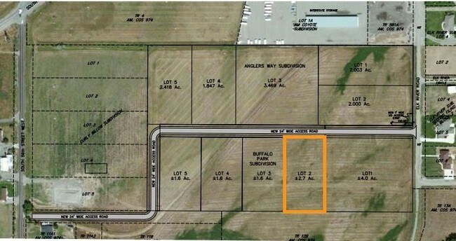
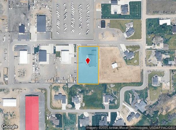
9402 Anglers Way
Billings, MT
Buffalo Park Sub (19)
03-0926-33-3-19-11-0000
BUFFALO PARK SUB, S33, T01 S, R25 E, BLOCK 1, LOT 2, (19)
Commercialnec
Yellowstone
X
Montana
30111C1435E
2
2024
1.61 AC
2025
Billings
001404
Other Market Areas
6,990 SF
DEMOGRAPHICS near 9402 Anglers Way
1 Mile
3 Mile
5 Mile
2024 Total Population
946
2,948
20,301
2029 Population
1,043
3,193
22,131
Pop Growth 2024-2029
+ 10.25%
+ 8.31%
+ 9.01%
Average Age
40
41
40
2024 Total Households
402
1,126
8,637
HH Growth 2024-2029
+ 10.70%
+ 8.79%
+ 9.30%
Median Household Inc
$76,531
$102,137
$77,273
Avg Household Size
2.30
2.50
2.30
2024 Avg HH Vehicles
2.00
3.00
2.00
Median Home Value
$392,352
$421,260
$345,414
Median Year Built
2001
1997
1997
Nearby Places
Map Layers
Map Styles
 Street
 Aerial
- Restaurants
- Banks
- Shops
- Fitness
- Groceries
PUBLIC TRANSPORTATION
AIRPORT
Billings Logan International
DRIVE
WALK
Distance
Billings Logan International
34 min
14.0 mi
Freight Ports
Port of Everett
DRIVE
WALK
Distance
Port of Everett
875 min
832.6 mi
SALE & LEASE HISTORY
LISTING DATE
SALE/LEASE

Aug 21, 2018
For Sale
Nearby Properties
Address
Land Use
TOTAL SIZE
Lot Size
Zoning
Address
Land Use
TOTAL SIZE
Lot Size
Zoning
145.51 AC
Address
Land Use
TOTAL SIZE
Lot Size
Zoning
77.63 AC
Address
Land Use
TOTAL SIZE
Lot Size
Zoning
156.04 AC
Address
Land Use
TOTAL SIZE
Lot Size
Zoning
13,216 SF
144.80 AC
A-1
Address
Land Use
TOTAL SIZE
Lot Size
Zoning
11,210 SF
14.37 AC
Address
Land Use
TOTAL SIZE
Lot Size
Zoning
168,560 SF
24.67 AC
Address
Land Use
TOTAL SIZE
Lot Size
Zoning
67.17 AC
Address
Land Use
TOTAL SIZE
Lot Size
Zoning
7,538 SF
59.81 AC
A-1
Address
Land Use
TOTAL SIZE
Lot Size
Zoning
53,255 SF
27.05 AC
Address
Land Use
TOTAL SIZE
Lot Size
Zoning
4,560 SF
12.57 AC
Address
Land Use
TOTAL SIZE
Lot Size
Zoning
115,720 SF
6.86 AC
Address
Land Use
TOTAL SIZE
Lot Size
Zoning
142,080 SF
10.02 AC
Address
Land Use
TOTAL SIZE
Lot Size
Zoning
53,440 SF
8.55 AC
Address
Land Use
TOTAL SIZE
Lot Size
Zoning
91,830 SF
7.81 AC
Address
Land Use
TOTAL SIZE
Lot Size
Zoning
65,815 SF
7.73 AC
Address
Land Use
TOTAL SIZE
Lot Size
Zoning
63,360 SF
2.96 AC
Address
Land Use
TOTAL SIZE
Lot Size
Zoning
27,499 SF
5 AC
Address
Land Use
TOTAL SIZE
Lot Size
Zoning
56,465 SF
4.75 AC
Address
Land Use
TOTAL SIZE
Lot Size
Zoning
62,000 SF
21.59 AC
7
Address
Land Use
TOTAL SIZE
Lot Size
Zoning
8,745 SF
10.22 AC
8
Address
Land Use
TOTAL SIZE
Lot Size
Zoning
11,925 SF
65 AC
Address
Land Use
TOTAL SIZE
Lot Size
Zoning
27,525 SF
8.86 AC
Address
Land Use
TOTAL SIZE
Lot Size
Zoning
12.13 AC
Address
Land Use
TOTAL SIZE
Lot Size
Zoning
24,170 SF
2.62 AC
Address
Land Use
TOTAL SIZE
Lot Size
Zoning
44,600 SF
7.11 AC
Address
Land Use
TOTAL SIZE
Lot Size
Zoning
3,578 SF
77.36 AC
Address
Land Use
TOTAL SIZE
Lot Size
Zoning
34,120 SF
7.63 AC
Address
Land Use
TOTAL SIZE
Lot Size
Zoning
8.28 AC
Address
Land Use
TOTAL SIZE
Lot Size
Zoning
17,112 SF
38.63 AC
The World's #1 Commercial Real Estate Marketplace
Connect with us
© 2025 CoStar Group
The information above has been obtained from sources believed reliable. While we do not doubt its accuracy we have not verified it and make no guarantee, warranty or representation about it. It is your responsibility to independently confirm its accuracy and completeness. Any projections, opinions, assumptions, or estimates used are for example only and do not represent the current or future performance of the property. The value of this transaction to you depends on tax and other factors which should be evaluated by your tax, financial, and legal advisors. You and your advisors should conduct a careful, independent investigation of the property to determine to your satisfaction the suitability of the property for your needs.