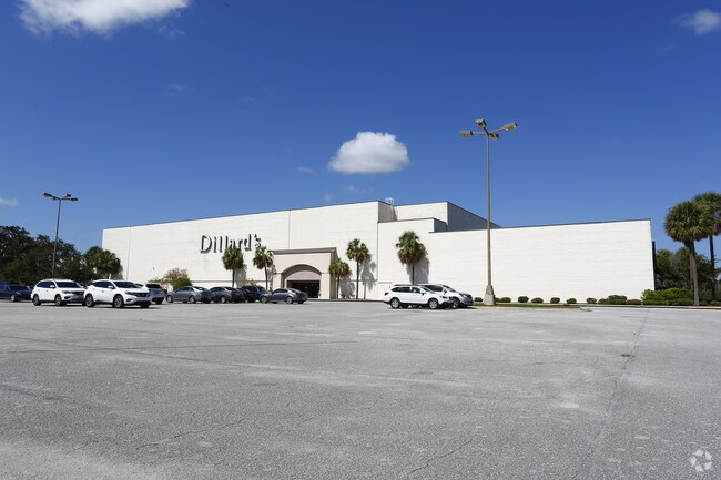
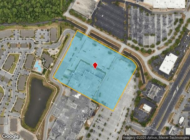
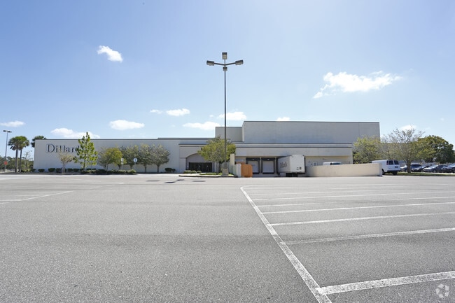
Property Record
9409 Us Highway 19, Port Richey, FL 34668

NEARBY LISTINGS FOR SALE OR LEASE
Property Detail
9409 Us Highway 19
Tampa-St. Petersburg-Clearwater, FL
Shopping Center Or Other Site
21-25-16-0000-00200-0040
COM N1/4 COR SEC TH ALG E LN OF NW1/4 S00DEG2939W 1678.87 FT TO WLY R/W LN US HWY 19 TH ALG SAID WLY R/W LN S28DEG38 51W 1148.01 FT TJ N26DEG08 16W 275.91 FT THS28DEG3851 W 30.15 FT TH S72DEG3351W 68.18 FT TH N13DEG1758.6W 180.10 FT TH 32.68 FT ALG A
Commercialacreage
Pasco
AE
Florida
12101C0187G
4
2024
10.38 AC
2025
Pasco County
031013
Tampa/St Petersburg
DEMOGRAPHICS near 9409 Us Highway 19
1 Mile
3 Mile
5 Mile
2024 Total Population
9,583
65,970
131,869
2029 Population
11,602
79,004
158,329
Pop Growth 2024-2029
+ 21.07%
+ 19.76%
+ 20.07%
Average Age
41
44
46
2024 Total Households
3,983
28,444
58,800
HH Growth 2024-2029
+ 21.06%
+ 19.78%
+ 20.12%
Median Household Inc
$43,071
$42,315
$45,769
Avg Household Size
2.30
2.30
2.20
2024 Avg HH Vehicles
1.00
1.00
2.00
Median Home Value
$142,723
$138,521
$167,040
Median Year Built
1977
1978
1979
Nearby Places
Map Layers
Map Styles
 Street
 Aerial
- Restaurants
- Banks
- Shops
- Fitness
- Groceries
PUBLIC TRANSPORTATION
AIRPORT
St Pete-Clearwater International
DRIVE
WALK
Distance
St Pete-Clearwater International
57 min
33.5 mi
Tampa International
DRIVE
WALK
Distance
Tampa International
56 min
36.7 mi
Freight Ports
Port of Tampa Bay
DRIVE
WALK
Distance
Port of Tampa Bay
68 min
42.2 mi
Nearby Properties
Address
Land Use
TOTAL SIZE
Lot Size
Zoning
Address
Land Use
TOTAL SIZE
Lot Size
Zoning
395,386 SF
35.63 AC
C2
Address
Land Use
TOTAL SIZE
Lot Size
Zoning
799,241 SF
88.92 AC
PUD
Address
Land Use
TOTAL SIZE
Lot Size
Zoning
248,561 SF
14.17 AC
C
Address
Land Use
TOTAL SIZE
Lot Size
Zoning
351,012 SF
23.51 AC
MF2
Address
Land Use
TOTAL SIZE
Lot Size
Zoning
220,843 SF
35.13 AC
C2
Address
Land Use
TOTAL SIZE
Lot Size
Zoning
141,740 SF
22.84 AC
PO1
Address
Land Use
TOTAL SIZE
Lot Size
Zoning
124,316 SF
22.91 AC
MF1
Address
Land Use
TOTAL SIZE
Lot Size
Zoning
122,037 SF
13.83 AC
MF1
Address
Land Use
TOTAL SIZE
Lot Size
Zoning
121,284 SF
10.25 AC
MF1
Address
Land Use
TOTAL SIZE
Lot Size
Zoning
91,660 SF
16.29 AC
C
Address
Land Use
TOTAL SIZE
Lot Size
Zoning
220,045 SF
22.67 AC
C2
Address
Land Use
TOTAL SIZE
Lot Size
Zoning
124,470 SF
5.09 AC
C2
Address
Land Use
TOTAL SIZE
Lot Size
Zoning
309,759 SF
65.19 AC
AC
Address
Land Use
TOTAL SIZE
Lot Size
Zoning
183,139 SF
19.66 AC
C2
Address
Land Use
TOTAL SIZE
Lot Size
Zoning
217,350 SF
11.20 AC
PUD
Address
Land Use
TOTAL SIZE
Lot Size
Zoning
76,160 SF
6.74 AC
MPUD
Address
Land Use
TOTAL SIZE
Lot Size
Zoning
220,024 SF
25.72 AC
C1
Address
Land Use
TOTAL SIZE
Lot Size
Zoning
86,570 SF
8.06 AC
MF1
Address
Land Use
TOTAL SIZE
Lot Size
Zoning
111,060 SF
9.31 AC
C3
Address
Land Use
TOTAL SIZE
Lot Size
Zoning
137,157 SF
18.59 AC
C2
Address
Land Use
TOTAL SIZE
Lot Size
Zoning
42,059 SF
9.16 AC
C3
Address
Land Use
TOTAL SIZE
Lot Size
Zoning
84,225 SF
5.21 AC
C2
Address
Land Use
TOTAL SIZE
Lot Size
Zoning
85,003 SF
25 AC
R4
Address
Land Use
TOTAL SIZE
Lot Size
Zoning
91,670 SF
3.51 AC
C2
Address
Land Use
TOTAL SIZE
Lot Size
Zoning
81,839 SF
3.33 AC
C2
Address
Land Use
TOTAL SIZE
Lot Size
Zoning
117,549 SF
8.07 AC
C2
Address
Land Use
TOTAL SIZE
Lot Size
Zoning
90,113 SF
8.22 AC
C2
Address
Land Use
TOTAL SIZE
Lot Size
Zoning
83,363 SF
5.97 AC
C2
Address
Land Use
TOTAL SIZE
Lot Size
Zoning
78,580 SF
21.43 AC
PUD
Address
Land Use
TOTAL SIZE
Lot Size
Zoning
35,013 SF
1.59 AC
R3
The World's #1 Commercial Real Estate Marketplace
Connect with us
© 2025 CoStar Group
The information above has been obtained from sources believed reliable. While we do not doubt its accuracy we have not verified it and make no guarantee, warranty or representation about it. It is your responsibility to independently confirm its accuracy and completeness. Any projections, opinions, assumptions, or estimates used are for example only and do not represent the current or future performance of the property. The value of this transaction to you depends on tax and other factors which should be evaluated by your tax, financial, and legal advisors. You and your advisors should conduct a careful, independent investigation of the property to determine to your satisfaction the suitability of the property for your needs.