Property Record
941 951 W Nimisila Rd W, Clinton, OH 44216

NEARBY LISTINGS FOR SALE OR LEASE
-
-
View all Clinton listings for sale on LoopNet.com
Property Detail
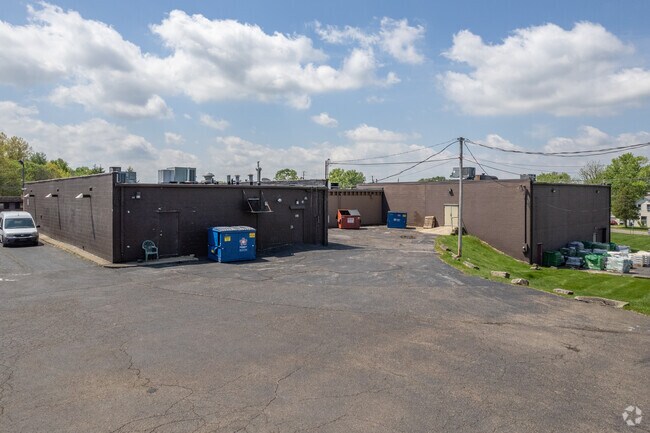
941 951 W Nimisila Rd W
Akron, OH
A Map Of The Town Of Manchester
23-00650
MANCHESTER LOT 57 ALL & PT VAC ST
Parkingstructure
Summit
X
Ohio
39153C0254E
57
2023
0.15 AC
2025
Akron
531702
Cleveland
DEMOGRAPHICS near 941 951 W Nimisila Rd W
1 Mile
3 Mile
5 Mile
2024 Total Population
2,246
13,817
53,940
2029 Population
2,191
13,555
53,359
Pop Growth 2024-2029
(2.45%)
(1.90%)
(1.08%)
Average Age
44
44
44
2024 Total Households
883
5,552
22,030
HH Growth 2024-2029
(2.49%)
(1.87%)
(1.10%)
Median Household Inc
$101,897
$86,070
$82,065
Avg Household Size
2.50
2.40
2.40
2024 Avg HH Vehicles
2.00
2.00
2.00
Median Home Value
$192,374
$192,608
$201,647
Median Year Built
1960
1967
1973
Nearby Places
Map Layers
Map Styles
 Street
 Aerial
- Restaurants
- Banks
- Shops
- Fitness
- Groceries
PUBLIC TRANSPORTATION
AIRPORT
Akron-Canton Regional
DRIVE
WALK
Distance
Akron-Canton Regional
21 min
10.4 mi
Freight Ports
Port of Toledo
DRIVE
WALK
Distance
Port of Toledo
173 min
143.2 mi
Nearby Properties
Address
Land Use
TOTAL SIZE
Lot Size
Zoning
Address
Land Use
TOTAL SIZE
Lot Size
Zoning
1,049.17 AC
Address
Land Use
TOTAL SIZE
Lot Size
Zoning
Address
Land Use
TOTAL SIZE
Lot Size
Zoning
Address
Land Use
TOTAL SIZE
Lot Size
Zoning
136,491 SF
35.31 AC
Address
Land Use
TOTAL SIZE
Lot Size
Zoning
110,301 SF
22.70 AC
Address
Land Use
TOTAL SIZE
Lot Size
Zoning
57,994 SF
105.09 AC
Address
Land Use
TOTAL SIZE
Lot Size
Zoning
Address
Land Use
TOTAL SIZE
Lot Size
Zoning
4,800 SF
493 AC
Address
Land Use
TOTAL SIZE
Lot Size
Zoning
99,887 SF
14.82 AC
Address
Land Use
TOTAL SIZE
Lot Size
Zoning
Address
Land Use
TOTAL SIZE
Lot Size
Zoning
47,384 SF
30.16 AC
Address
Land Use
TOTAL SIZE
Lot Size
Zoning
62,000 SF
6.91 AC
Address
Land Use
TOTAL SIZE
Lot Size
Zoning
Address
Land Use
TOTAL SIZE
Lot Size
Zoning
38,078 SF
6.15 AC
Address
Land Use
TOTAL SIZE
Lot Size
Zoning
39,266 SF
21.17 AC
Address
Land Use
TOTAL SIZE
Lot Size
Zoning
Address
Land Use
TOTAL SIZE
Lot Size
Zoning
22,478 SF
8.50 AC
Address
Land Use
TOTAL SIZE
Lot Size
Zoning
25,264 SF
8.60 AC
Address
Land Use
TOTAL SIZE
Lot Size
Zoning
5,028 SF
16.22 AC
Address
Land Use
TOTAL SIZE
Lot Size
Zoning
11,695 SF
11.64 AC
Address
Land Use
TOTAL SIZE
Lot Size
Zoning
Address
Land Use
TOTAL SIZE
Lot Size
Zoning
110 AC
Address
Land Use
TOTAL SIZE
Lot Size
Zoning
9,228 SF
22.42 AC
Address
Land Use
TOTAL SIZE
Lot Size
Zoning
20,016 SF
3.99 AC
Address
Land Use
TOTAL SIZE
Lot Size
Zoning
1,976 SF
136.83 AC
Address
Land Use
TOTAL SIZE
Lot Size
Zoning
19,126 SF
7.11 AC
Address
Land Use
TOTAL SIZE
Lot Size
Zoning
26,168 SF
9.34 AC
Address
Land Use
TOTAL SIZE
Lot Size
Zoning
Address
Land Use
TOTAL SIZE
Lot Size
Zoning
146.57 AC
Address
Land Use
TOTAL SIZE
Lot Size
Zoning
1,720 SF
111.34 AC
The World's #1 Commercial Real Estate Marketplace
Connect with us
© 2025 CoStar Group
The information above has been obtained from sources believed reliable. While we do not doubt its accuracy we have not verified it and make no guarantee, warranty or representation about it. It is your responsibility to independently confirm its accuracy and completeness. Any projections, opinions, assumptions, or estimates used are for example only and do not represent the current or future performance of the property. The value of this transaction to you depends on tax and other factors which should be evaluated by your tax, financial, and legal advisors. You and your advisors should conduct a careful, independent investigation of the property to determine to your satisfaction the suitability of the property for your needs.