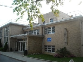
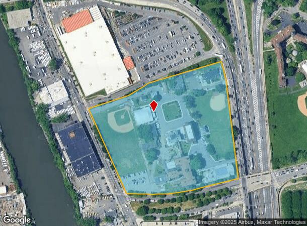
Property Record
941 Hutchinson River Pkwy, Bronx, NY 10465
NEARBY LISTINGS FOR SALE OR LEASE
Property Detail
941 Hutchinson River Pkwy
05542-0001
Bronx
Religious
New York
X
1
3604970104F
1.10 AC
0
Bronx
2025
Westchester/So Connecticut
015800
New York-Jersey City-White Plains, NY-NJ
19,050 SF
DEMOGRAPHICS near 941 Hutchinson River Pkwy
1 Mile
3 Mile
5 Mile
2024 Total Population
43,171
425,550
1,537,141
2029 Population
38,083
386,428
1,423,246
Pop Growth 2024-2029
(11.79%)
(9.19%)
(7.41%)
Average Age
39
39
39
2024 Total Households
14,991
149,851
536,703
HH Growth 2024-2029
(12.33%)
(9.93%)
(8.08%)
Median Household Inc
$48,298
$49,456
$44,691
Avg Household Size
2.80
2.70
2.70
2024 Avg HH Vehicles
1.00
1.00
1.00
Median Home Value
$654,910
$634,355
$595,363
Median Year Built
1956
1954
1954
Nearby Places
- Restaurants
- Banks
- Shops
- Fitness
- Groceries
PUBLIC TRANSPORTATION
TRANSIT/SUBWAY
Zerega Avenue (6 - New York MTA Subway (The Subway))
DRIVE
WALK
Distance
Zerega Avenue (6 - New York MTA Subway (The Subway))
4 min
19 min
1.0 mi
Castle Hill Avenue (6 - New York MTA Subway (The Subway))
DRIVE
WALK
Distance
Castle Hill Avenue (6 - New York MTA Subway (The Subway))
3 min
20 min
1.0 mi
COMMUTER RAIL
Tremont Station (Harlem Line - Metro-North Commuter Railroad Company (Metro-North))
DRIVE
WALK
Distance
Tremont Station (Harlem Line - Metro-North Commuter Railroad Company (Metro-North))
8 min
4.0 mi
Botanical Garden Station (Harlem Line - Metro-North Commuter Railroad Company (Metro-North))
DRIVE
WALK
Distance
Botanical Garden Station (Harlem Line - Metro-North Commuter Railroad Company (Metro-North))
11 min
4.9 mi
AIRPORT
LaGuardia
DRIVE
WALK
Distance
LaGuardia
15 min
7.5 mi
John F Kennedy International
DRIVE
WALK
Distance
John F Kennedy International
21 min
15.1 mi
Westchester County
DRIVE
WALK
Distance
Westchester County
34 min
22.7 mi
Freight Ports
NY - Red Hook Container Terminal
DRIVE
WALK
Distance
NY - Red Hook Container Terminal
30 min
18.1 mi
Nearby Properties
Address
Land Use
TOTAL SIZE
Lot Size
Zoning
Address
Land Use
TOTAL SIZE
Lot Size
Zoning
550,000 SF
8.75 AC
M1-1
Address
Land Use
TOTAL SIZE
Lot Size
Zoning
1,427,393 SF
39.94 AC
R4
Address
Land Use
TOTAL SIZE
Lot Size
Zoning
5,000 SF
363.58 AC
PARK
Address
Land Use
TOTAL SIZE
Lot Size
Zoning
1,012,000 SF
7.79 AC
R6
Address
Land Use
TOTAL SIZE
Lot Size
Zoning
485,484 SF
39.63 AC
R5
Address
Land Use
TOTAL SIZE
Lot Size
Zoning
667,405 SF
5.51 AC
R6
Address
Land Use
TOTAL SIZE
Lot Size
Zoning
390,750 SF
265 AC
PARK
Address
Land Use
TOTAL SIZE
Lot Size
Zoning
703,265 SF
83.45 AC
R4
Address
Land Use
TOTAL SIZE
Lot Size
Zoning
537,208 SF
4.73 AC
C4-3
Address
Land Use
TOTAL SIZE
Lot Size
Zoning
851,821 SF
7.95 AC
R4
Address
Land Use
TOTAL SIZE
Lot Size
Zoning
426,172 SF
14.30 AC
M3-1
Address
Land Use
TOTAL SIZE
Lot Size
Zoning
14,681 SF
97 AC
PARK
Address
Land Use
TOTAL SIZE
Lot Size
Zoning
127,000 SF
16.53 AC
M3-1
Address
Land Use
TOTAL SIZE
Lot Size
Zoning
489,326 SF
19.18 AC
C8-1
Address
Land Use
TOTAL SIZE
Lot Size
Zoning
361,354 SF
C4-2
Address
Land Use
TOTAL SIZE
Lot Size
Zoning
1,172,005 SF
128.83 AC
M1-1
Address
Land Use
TOTAL SIZE
Lot Size
Zoning
510 SF
68.73 AC
PARK
Address
Land Use
TOTAL SIZE
Lot Size
Zoning
601,260 SF
3.27 AC
R4
Address
Land Use
TOTAL SIZE
Lot Size
Zoning
450,879 SF
9.10 AC
M1-1
Address
Land Use
TOTAL SIZE
Lot Size
Zoning
450,000 SF
5.59 AC
R6
Address
Land Use
TOTAL SIZE
Lot Size
Zoning
726,051 SF
33.66 AC
R5
Address
Land Use
TOTAL SIZE
Lot Size
Zoning
274,840 SF
2.80 AC
M1-1
Address
Land Use
TOTAL SIZE
Lot Size
Zoning
674,889 SF
51.55 AC
M3-1
Address
Land Use
TOTAL SIZE
Lot Size
Zoning
16,300 SF
148.32 AC
PARK
Address
Land Use
TOTAL SIZE
Lot Size
Zoning
464,700 SF
5.07 AC
R4
Address
Land Use
TOTAL SIZE
Lot Size
Zoning
1,214,370 SF
13.09 AC
R6
Address
Land Use
TOTAL SIZE
Lot Size
Zoning
262,716 SF
2.80 AC
M1-1
Address
Land Use
TOTAL SIZE
Lot Size
Zoning
1,172,800 SF
19.66 AC
R4
Address
Land Use
TOTAL SIZE
Lot Size
Zoning
10,181 SF
30.72 AC
M1-1
Address
Land Use
TOTAL SIZE
Lot Size
Zoning
164,110 SF
8.07 AC
M1-2
The World's #1 Commercial Real Estate Marketplace
Connect with us
© 2025 CoStar Group
The information above has been obtained from sources believed reliable. While we do not doubt its accuracy we have not verified it and make no guarantee, warranty or representation about it. It is your responsibility to independently confirm its accuracy and completeness. Any projections, opinions, assumptions, or estimates used are for example only and do not represent the current or future performance of the property. The value of this transaction to you depends on tax and other factors which should be evaluated by your tax, financial, and legal advisors. You and your advisors should conduct a careful, independent investigation of the property to determine to your satisfaction the suitability of the property for your needs.